
Advanced Search for Maps
Showing 51-60 of 132
Official, Figure in hazard assessment
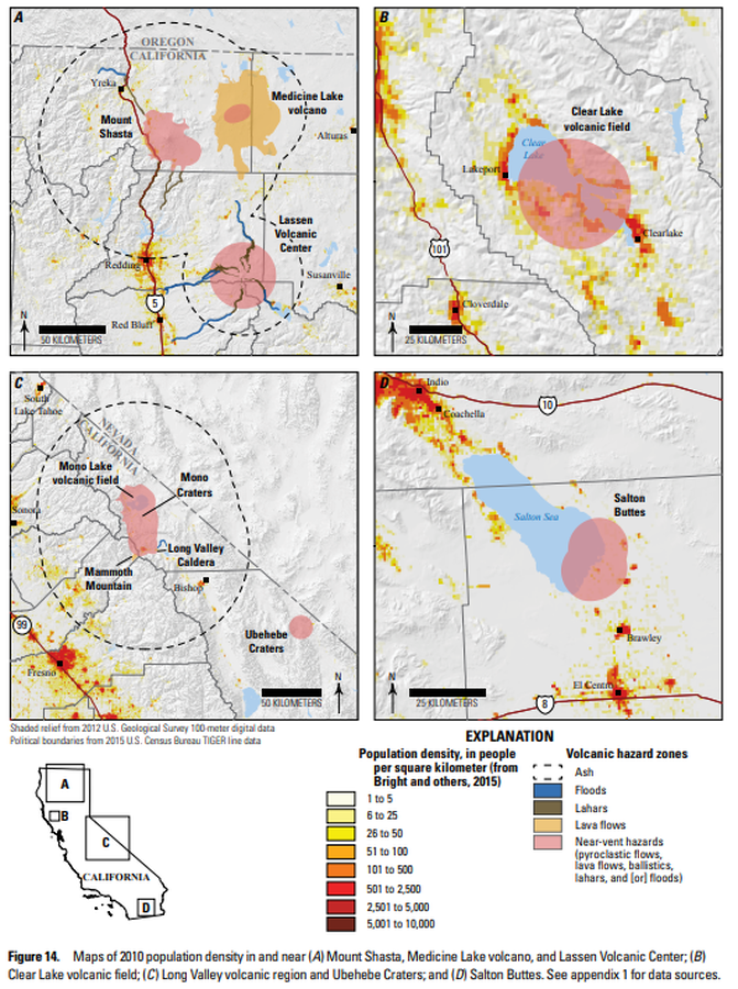
Maps of 2010 population density in and near (A) Mount Shasta, Medicine Lake volcano, and Lassen Volcanic Center; (B ) Clear Lake volcanic field; (C ) Long Valley volcanic region and Ubehebe Craters; and (D ) Salton Buttes
Figure 14 in: Mangan, M., Ball, J., Wood, N., Jones, J.L., Peters, J., Abdollahian, N., Dinitz, L., Blankenheim, S., Fenton, J., & Pridmore, C. (2019). California’s exposure to volcanic hazards. U.S. Geological Survey Scientific Investigations Report 2018–5159, v. 1.1, 49 p. https://doi.org/10.3133/sir20185159
Official, Insert/poster-size map with accompanying report
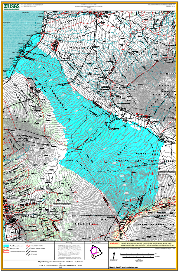
Maps Showing Lava Inundation Zones for Mauna Loa, Hawai'i - Map 10. Puako lava inundation zone
Sheet 10 in: Trusdell, F.A., Graves, P., & Tincher, C.R. (2002). Map Showing Lava Inundation Zones for Mauna Loa, Hawai‘i. U.S. Geological Survey, Miscellaneous Field Studies Map MF-2401. 10 Map Sheets (each 22 x 34 inches); Pamphlet (14 p.) scale 1:70000. https://doi.org/10.3133/mf2401

Official, Insert/poster-size map with accompanying report
Maps Showing Lava Inundation Zones for Mauna Loa, Hawai'i - Map 2. Kaumana, Waiakea, and Volcano-Mountain View inundation zones
Sheet 2 in: Trusdell, F.A., Graves, P., & Tincher, C.R. (2002). Map Showing Lava Inundation Zones for Mauna Loa, Hawai‘i. U.S. Geological Survey, Miscellaneous Field Studies Map MF-2401. 10 Map Sheets (each 22 x 34 inches); Pamphlet (14 p.) scale 1:70000. https://doi.org/10.3133/mf2401

Official, Insert/poster-size map with accompanying report
Maps Showing Lava Inundation Zones for Mauna Loa, Hawai'i - Map 3. Kapapala inundation zone
Sheet 3 in: Trusdell, F.A., Graves, P., & Tincher, C.R. (2002). Map Showing Lava Inundation Zones for Mauna Loa, Hawai‘i. U.S. Geological Survey, Miscellaneous Field Studies Map MF-2401. 10 Map Sheets (each 22 x 34 inches); Pamphlet (14 p.) scale 1:70000. https://doi.org/10.3133/mf2401
Official, Insert/poster-size map with accompanying report
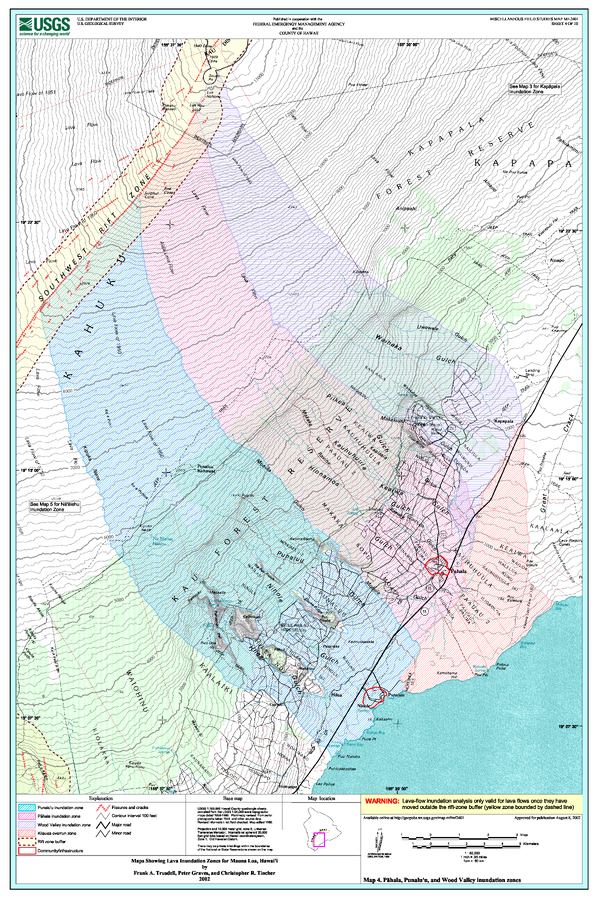
Maps Showing Lava Inundation Zones for Mauna Loa, Hawai'i - Map 4. Pahala, Punalu'u, and Wood Valley inundation zones
Sheet 4 in: Trusdell, F.A., Graves, P., & Tincher, C.R. (2002). Map Showing Lava Inundation Zones for Mauna Loa, Hawai‘i. U.S. Geological Survey, Miscellaneous Field Studies Map MF-2401. 10 Map Sheets (each 22 x 34 inches); Pamphlet (14 p.) scale 1:70000. https://doi.org/10.3133/mf2401
Official, Insert/poster-size map with accompanying report
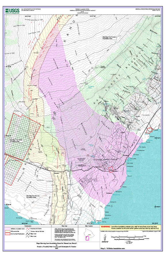
Maps Showing Lava Inundation Zones for Mauna Loa, Hawai'i - Map 5. Na'alehu inundation zone
Sheet 5 in: Trusdell, F.A., Graves, P., & Tincher, C.R. (2002). Map Showing Lava Inundation Zones for Mauna Loa, Hawai‘i. U.S. Geological Survey, Miscellaneous Field Studies Map MF-2401. 10 Map Sheets (each 22 x 34 inches); Pamphlet (14 p.) scale 1:70000. https://doi.org/10.3133/mf2401

Official, Insert/poster-size map with accompanying report
Maps Showing Lava Inundation Zones for Mauna Loa, Hawai'i - Map 6. Ka Lae inundation zone
Sheet 6 in: Trusdell, F.A., Graves, P., & Tincher, C.R. (2002). Map Showing Lava Inundation Zones for Mauna Loa, Hawai‘i. U.S. Geological Survey, Miscellaneous Field Studies Map MF-2401. 10 Map Sheets (each 22 x 34 inches); Pamphlet (14 p.) scale 1:70000. https://doi.org/10.3133/mf2401

Official, Insert/poster-size map with accompanying report
Maps Showing Lava Inundation Zones for Mauna Loa, Hawai'i - Map 7. HOVE, Kapu'a, and Miloli'i inundation zones
Sheet 7 in: Trusdell, F.A., Graves, P., & Tincher, C.R. (2002). Map Showing Lava Inundation Zones for Mauna Loa, Hawai‘i. U.S. Geological Survey, Miscellaneous Field Studies Map MF-2401. 10 Map Sheets (each 22 x 34 inches); Pamphlet (14 p.) scale 1:70000. https://doi.org/10.3133/mf2401

Official, Insert/poster-size map with accompanying report
Maps Showing Lava Inundation Zones for Mauna Loa, Hawai'i - Map 8. Ho'okena, Ka'ohe, and Ka'apuna inundation zones
Sheet 8 in: Trusdell, F.A., Graves, P., & Tincher, C.R. (2002). Map Showing Lava Inundation Zones for Mauna Loa, Hawai‘i. U.S. Geological Survey, Miscellaneous Field Studies Map MF-2401. 10 Map Sheets (each 22 x 34 inches); Pamphlet (14 p.) scale 1:70000. https://doi.org/10.3133/mf2401
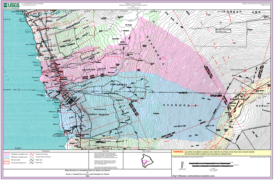
Official, Insert/poster-size map with accompanying report
Maps Showing Lava Inundation Zones for Mauna Loa, Hawai'i - Map 9. Honaunau and Kealakekua inundation zones
Sheet 9 in: Trusdell, F.A., Graves, P., & Tincher, C.R. (2002). Map Showing Lava Inundation Zones for Mauna Loa, Hawai‘i. U.S. Geological Survey, Miscellaneous Field Studies Map MF-2401. 10 Map Sheets (each 22 x 34 inches); Pamphlet (14 p.) scale 1:70000. https://doi.org/10.3133/mf2401