
Advanced Search for Maps
Showing 31-40 of 132
Official (foreign agency), Insert/poster-size map with accompanying report
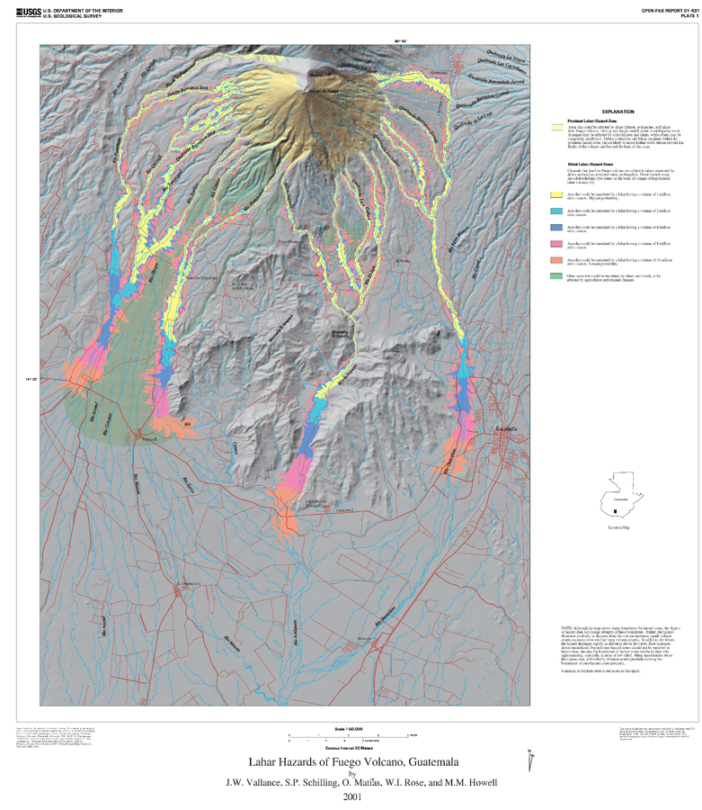
Lahar Hazards of Fuego Volcano, Guatemala
Plate 1 (Color) in: Vallance, J.W., Schilling, S.P., Matías, O., Rose, W.I. & Howell, M.M. (2001). Volcano Hazards at Fuego and Acatenango, Guatemala. U.S. Geological Survey, Open-File Report 01-431. https://doi.org/10.3133/ofr01431
Official (foreign agency), Insert/poster-size map with accompanying report
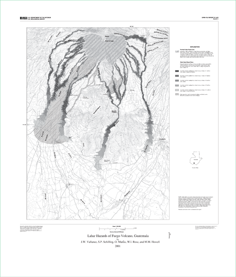
Lahar Hazards of Fuego Volcano, Guatemala
Plate 1 (B&W) in: Vallance, J.W., Schilling, S.P., Matías, O., Rose, W.I. & Howell, M.M. (2001). Volcano Hazards at Fuego and Acatenango, Guatemala. U.S. Geological Survey, Open-File Report 01-431. https://doi.org/10.3133/ofr01431
Official, Figure in a journal article
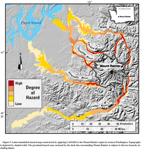
Lahar-inundation hazard map constructed by applying LAHARZ to the Mount Rainier region in western Washington
Figure 9 in: Iverson, R. M., Schilling, S. P., & Vallance, J. W. (1998). Objective delineation of lahar-inundation hazard zones. Geological Society of America Bulletin, 110(8), 972-984. https://doi.org/10.1130/0016-7606(1998)110<0972:ODOLIH>2.3.CO;2
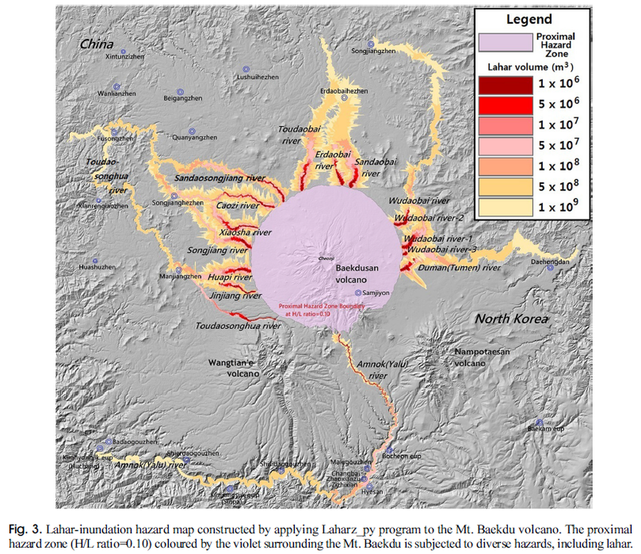
Figure in a journal article
Lahar-inundation hazard map constructed by applying Laharz_py program to the Mt. Baekdu volcano
Figure 3 in: Yun, S. H. & Chang, C. (2017). Prediction of Lahar Flow Inundation Areas Using LAHARZ_py Program: Application for the Mt. Baekdu Volcano. Economic and Environmental Geology, 50(4), 277-286. https://doi.org/10.9719/EEG.2017.50.4.277
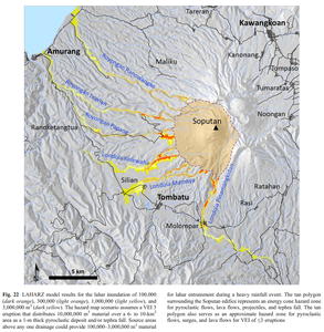
Figure in a journal article
LAHARZ model results for the lahar inundation of 100,000 (dark orange), 300,000 (light orange), 1,000,000 (light yellow), and 3,000,000 m³ (dark yellow)
Figure 22 in: Kushendratno, Pallister, J.S., Kristianto, Bina, F.R., McCausland, W., Carn, S., Haerani, N., Griswold, J., & Keeler, R. (2012). Recent explosive eruptions and volcano hazards at Soputan volcano—a basalt stratovolcano in north Sulawesi, Indonesia. Bulletin of volcanology, 74(7), 1581-1609. https://doi.org/10.1007/s00445-012-0620-2
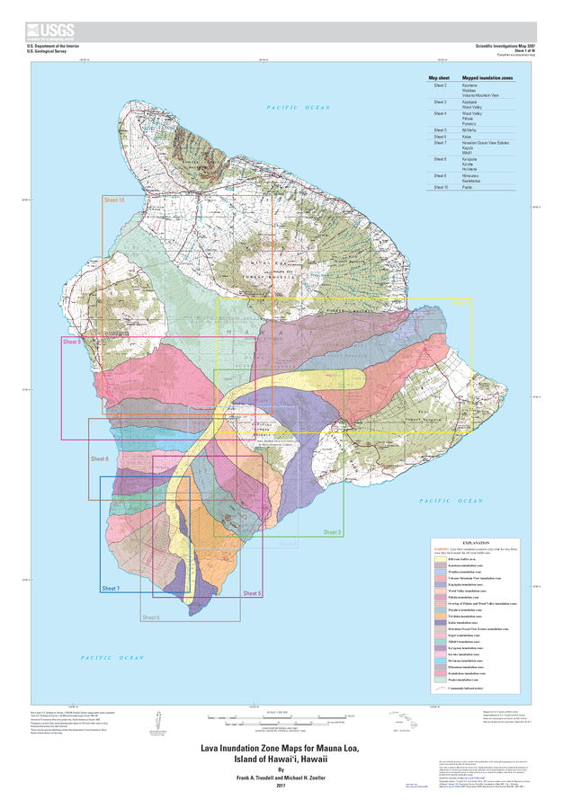
Official, Insert/poster-size map with accompanying report
Lava Inundation Zone Maps for Mauna Loa, Island of Hawaiʻi, Hawaii
Sheet 1 in: Trusdell, F.A. & Zoeller, M.H. (2017). Lava inundation zone maps for Mauna Loa, Island of Hawaiʻi, Hawaii. U.S. Geological Survey, Scientific Investigations Map 3387, 12 p., 10 sheets. https://doi.org/10.3133/sim3387

Official, Figure in hazard assessment
Map of natural gas pipelines and substations in northern California
Figure 20 in: Mangan, M., Ball, J., Wood, N., Jones, J.L., Peters, J., Abdollahian, N., Dinitz, L., Blankenheim, S., Fenton, J., & Pridmore, C. (2019). California’s exposure to volcanic hazards. U.S. Geological Survey Scientific Investigations Report 2018–5159, v. 1.1, 49 p. https://doi.org/10.3133/sir20185159
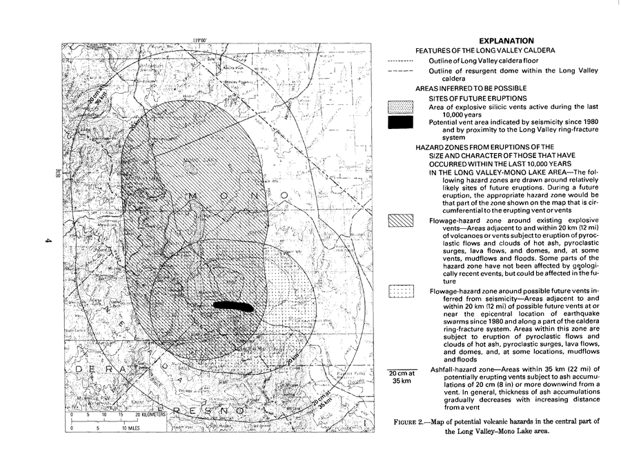
Official, Figure in hazard assessment
Map of potential volcanic hazards in the central part of the Long Valley-Mono Lake area
Figure 2 in: Miller, C.D., Mullineaux, D.R., Crandell, D.R. & Bailey, R.A. (1982). Potential hazards from future volcanic eruptions in the Long Valley-Mono Lake area, east-central California and southwest Nevada; a preliminary assessment. U.S. Geological Survey, Circular 877, 10 p. https://doi.org/10.3133/cir877
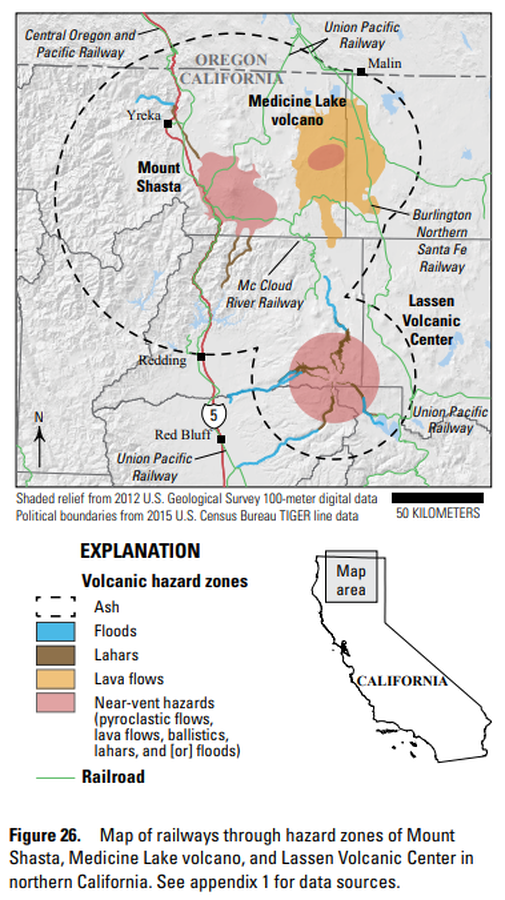
Official, Figure in hazard assessment
Map of railways through hazard zones of Mount Shasta, Medicine Lake volcano, and Lassen Volcanic Center in northern California
Figure 26 in: Mangan, M., Ball, J., Wood, N., Jones, J.L., Peters, J., Abdollahian, N., Dinitz, L., Blankenheim, S., Fenton, J., & Pridmore, C. (2019). California’s exposure to volcanic hazards. U.S. Geological Survey Scientific Investigations Report 2018–5159, v. 1.1, 49 p. https://doi.org/10.3133/sir20185159
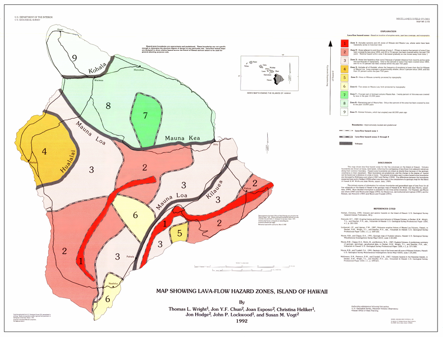
Official, Map sheet or poster
Map Showing Lava-Flow Hazard Zones, Island of Hawaii
Wright, T.L., Chun, J.Y.F., Exposo, J., Heliker, C., Hodge, J., Lockwood, J.P., & Vogt, S.M. (1992). Map showing lava-flow hazard zones, Island of Hawaii. U.S. Geological Survey, Miscellaneous Field Studies Map 2193, scale 1:250,000. https://doi.org/10.3133/mf2193