
Advanced Search for Maps
Showing 61-70 of 132
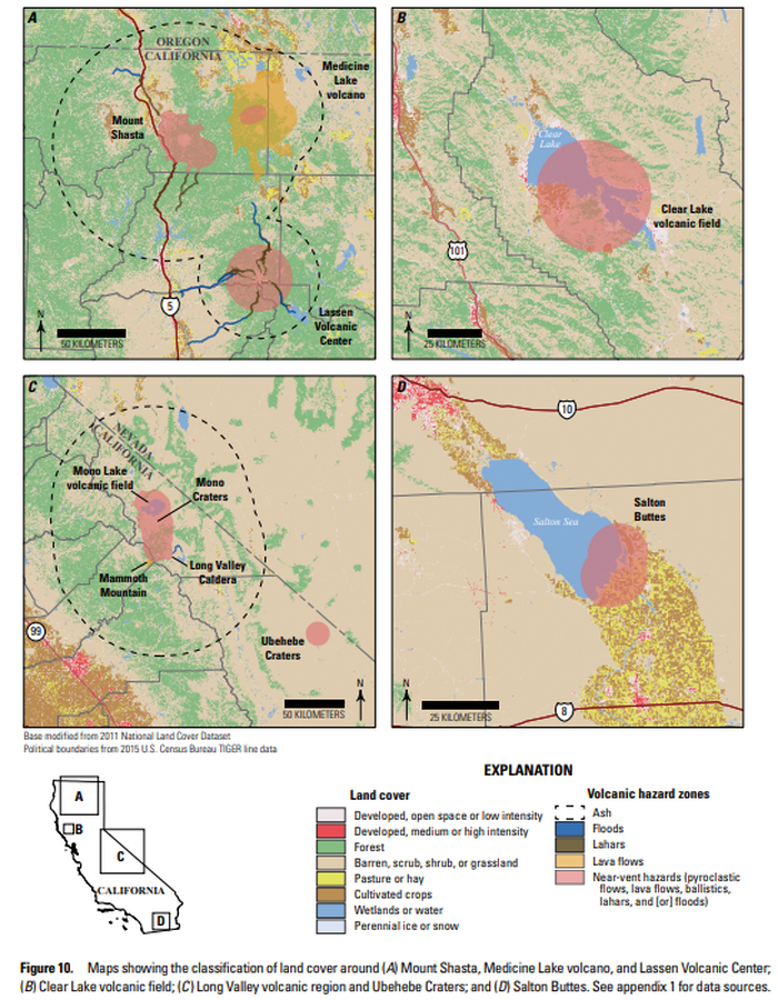
Official, Figure in hazard assessment
Maps showing the classification of land cover around (A) Mount Shasta, Medicine Lake volcano, and Lassen Volcanic Center; (B) Clear Lake volcanic field; (C ) Long Valley volcanic region and Ubehebe Craters; and (D) Salton Buttes
Figure 10 in: Mangan, M., Ball, J., Wood, N., Jones, J.L., Peters, J., Abdollahian, N., Dinitz, L., Blankenheim, S., Fenton, J., & Pridmore, C. (2019). California’s exposure to volcanic hazards. U.S. Geological Survey Scientific Investigations Report 2018–5159, v. 1.1, 49 p. https://doi.org/10.3133/sir20185159
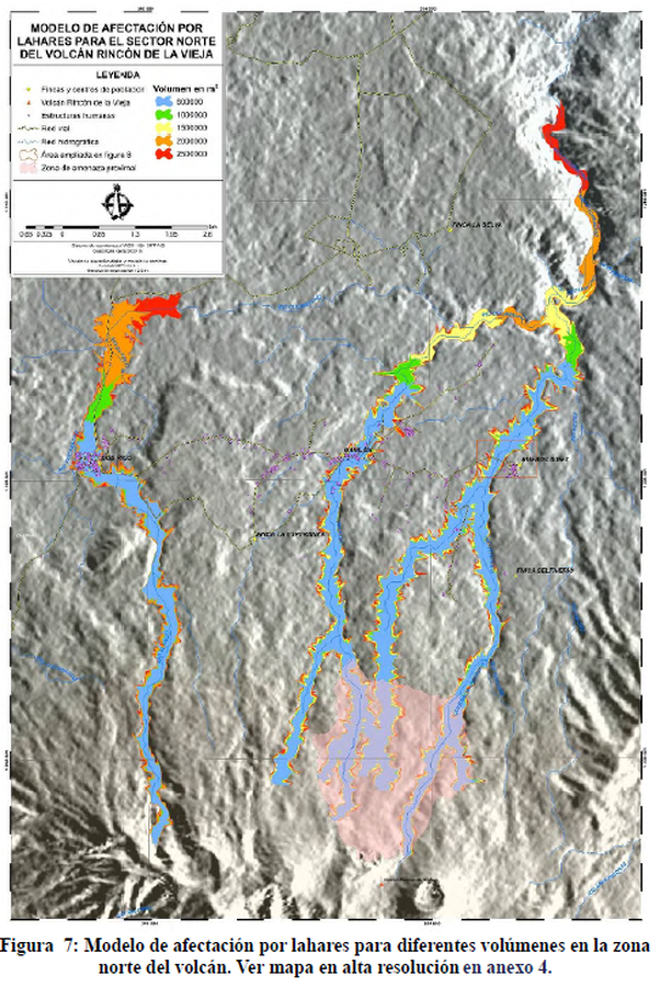
Figure in a thesis or dissertation
Modelo de Afectación por Lahares para el Sector Norte del Volcán Rincón de la Vieja
(Lahars Affectation Model for the North Sector of the Rincon de la Vieja Volcano)
Figure 7 in: Alpízar, Y. (2018). Mapa Preliminar de Peligros Volcánicos para el Volcán Rincón de la Vieja (Costa Rica): Descripción de un Escenario de Afectación por Lahares. Ciudad Universitaria Rodrigo Facio, Costa Rica. 160 p.
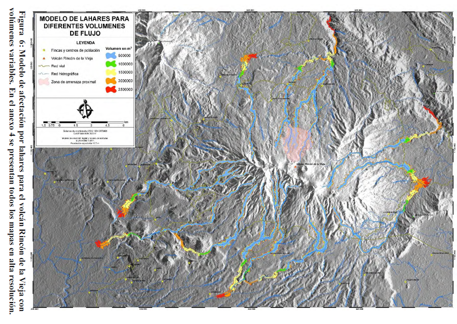
Figure in a thesis or dissertation
Modelo de Lahares para Diferentes Volumenes de Flujo
(Model of Lahars for Different Flow Volumes)
Figure 6 in: Alpízar, Y. (2018). Mapa Preliminar de Peligros Volcánicos para el Volcán Rincón de la Vieja (Costa Rica): Descripción de un Escenario de Afectación por Lahares. Ciudad Universitaria Rodrigo Facio, Costa Rica. 160 p.
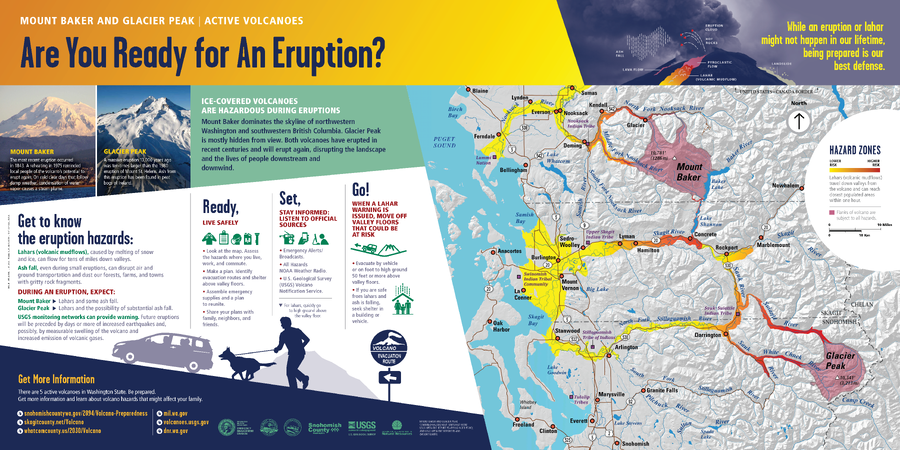
Official, Sign or billboard
Mount Baker and Glacier Peak | Active Volcanoes. Are You Ready for An Eruption?
Washington Department of Natural Resources. (2014). Mount Baker and Glacier Peak, Active Volcanoes, Are You Ready for An Eruption? Mount Baker And Glacier Peak Combined Hazard Map. (Simplified from: Waitt et al. 1995 and Gardner et al. 1995)
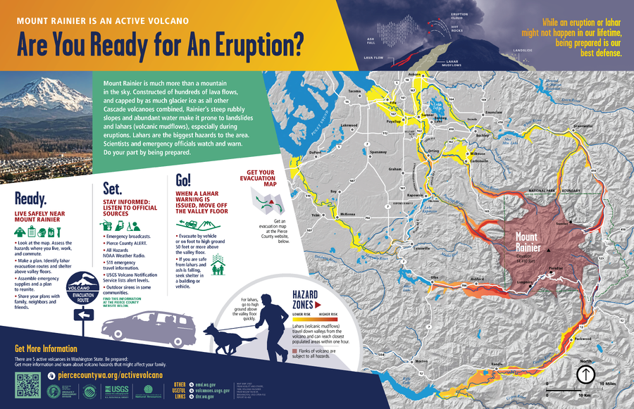
Official, Sign or billboard
Mount Rainier is An Active Volcano, Are You Ready for An Eruption?
Washington Department of Natural Resources. (2014). Mount Rainier is An Active Volcano, Are You Ready for An Eruption? (Simplified from: Hoblitt et al. 1998)
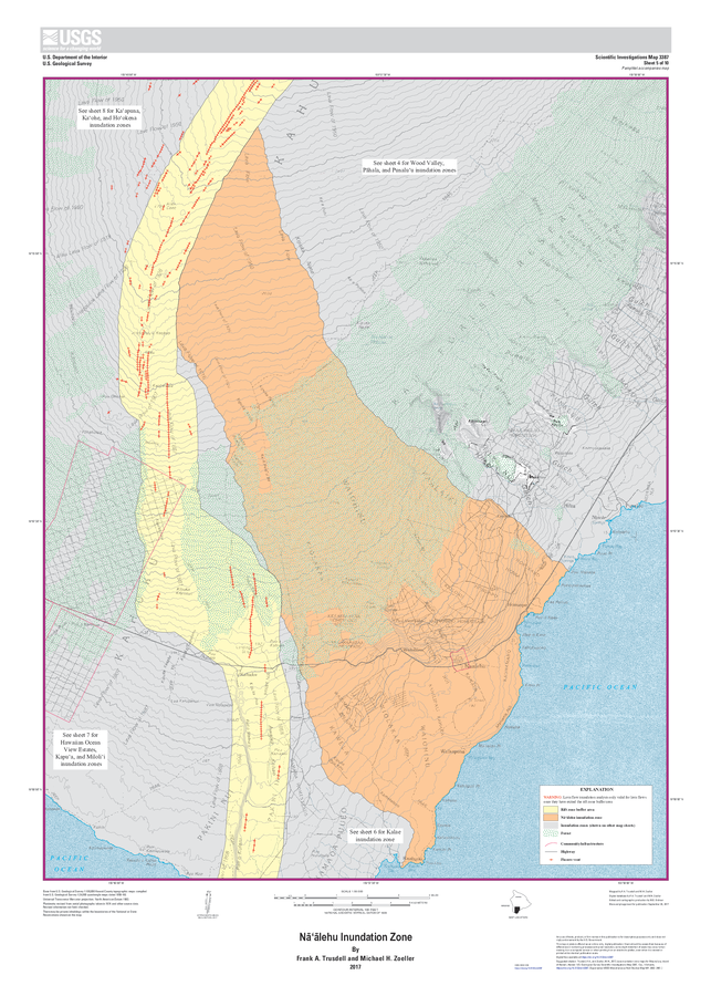
Official, Insert/poster-size map with accompanying report
Nāʻālehu Inundation Zone
Sheet 5 in: Trusdell, F.A. & Zoeller, M.H. (2017). Lava inundation zone maps for Mauna Loa, Island of Hawaiʻi, Hawaii. U.S. Geological Survey, Scientific Investigations Map 3387, 12 p., 10 sheets. https://doi.org/10.3133/sim3387
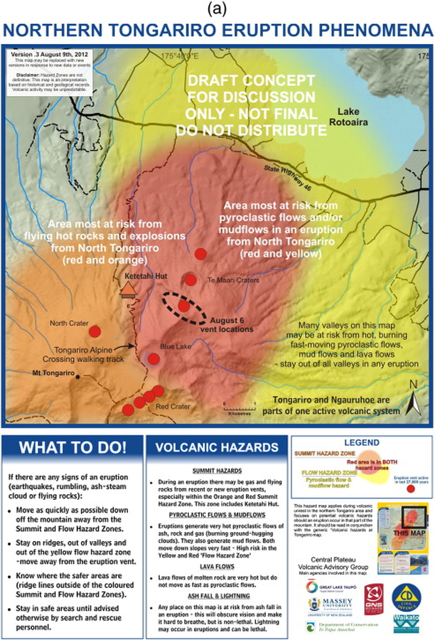
Official, Map sheet or poster
Northern Tongariro Eruption Phenomena
GNS Science (compiler). (2012). Te Maari Eruption Phenomena. Version 0.3, 9 August 2012. (Reprinted in: Leonard, G. S., Stewart, C., Wilson, T. M., Procter, J. N., Scott, B. J., Keys, H. J., Jolly, G.E., Wardman, J.B., Cronin. S.J. & McBride, S. K. (2014). Integrating multidisciplinary science, modelling and impact data into evolving, syn-event volcanic hazard mapping and communication: a case study from the 2012 Tongariro eruption crisis, New Zealand. Journal of Volcanology and Geothermal Research, 286, p. 208-232. https://doi.org/10.1016/j.jvolgeores.2014.08.018)
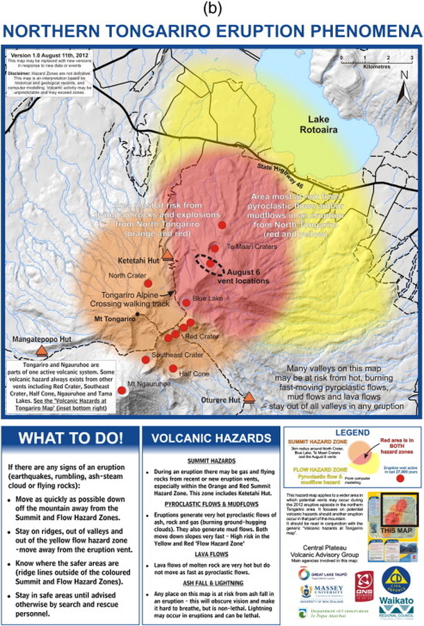
Official, Map sheet or poster
Northern Tongariro Eruption Phenomena
GNS Science (compiler). (2012). Te Maari Eruption Phenomena. Version 1.0, 11 August 2012. (Reprinted in: Leonard, G. S., Stewart, C., Wilson, T. M., Procter, J. N., Scott, B. J., Keys, H. J., Jolly, G.E., Wardman, J.B., Cronin. S.J. & McBride, S. K. (2014). Integrating multidisciplinary science, modelling and impact data into evolving, syn-event volcanic hazard mapping and communication: a case study from the 2012 Tongariro eruption crisis, New Zealand. Journal of Volcanology and Geothermal Research, 286, p. 208-232. https://doi.org/10.1016/j.jvolgeores.2014.08.018)
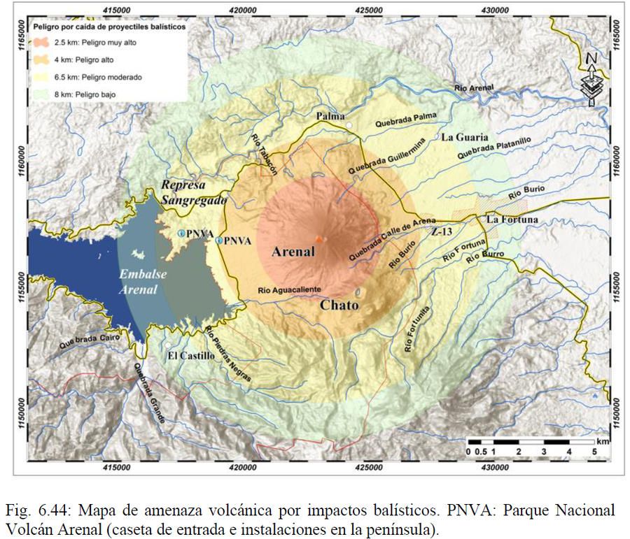
Official, Figure in hazard assessment
Peligro por caída de proyectiles balísticos
(Danger from falling ballistic projectiles)
Figure 6.44 in: Alvarado, G.E., Brenes-André, F., Núñez, D., Borbón, J., Ramírez, M.A., Alpízar, Y., Núñez, S., Sibaja, J.P., Esquivel, L. (2023). Actualización del Análisis del Peligro Volcánico del Arenal, Costa Rica. Instituto Costarricense de Electricidad (ICE). Mayo 2023.
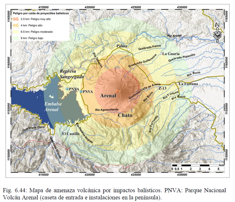