
Advanced Search for Maps
Showing 11-20 of 553
Official, Flyer, brochure, short fact-sheet, or handout
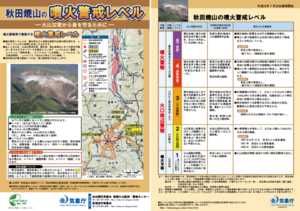
Akita-Yakeyama Volcanic Alert Levels
Japan Meteorological Agency. (2016). Akita-Yakeyama Volcanic Alert Levels. Volcano Monitoring and Warning Center, Volcano Division, Earthquake and Volcano Department.
Official, Map in a booklet, long fact-sheet, or handbook
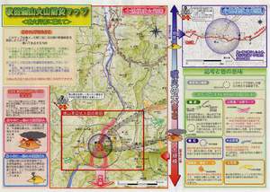
Akita-Yakeyama Volcanic Disaster Prevention Map
Akita Prefecture. (2002). Akita-Yakeyama Volcanic Disaster Prevention Map.
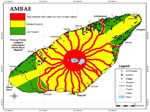
Figure in a journal article
Ambae
Cronin, S.J., Gaylord, D.R., Charley, D., Alloway, B.V., Wallez, S., & Esau, J.W. (2004). Participatory methods of incorporating scientific with traditional knowledge for volcanic hazard management on Ambae Island, Vanuatu. Bulletin of volcanology, 66(7), p. 652-668. https://doi.org/10.1007/s00445-004-0347-9. (Reprinted in: Cronin, S. J., & Németh, K., Stewart, R.B. (2006). Volcanic hazards planning on rifting island and fissure volcanoes. Joint Conference of the Geological Society of New Zealand and the New Zealand Geophysical Society.)
Official, Map sheet or poster
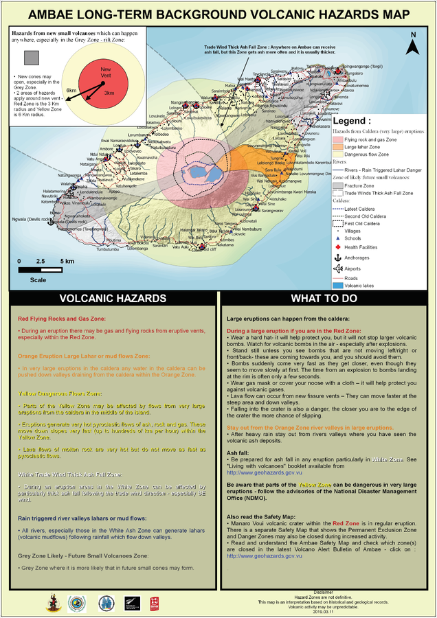
Ambae Long-Term Background Volcanic Hazards Map
Vanuatu Meteorology & Geo-Hazards Department. (2019). Ambae Long-Term Background Volcanic Hazards Map. Government of Vanuatu, Vanuatu Meteorology & Geo-Hazards Department, Vanuatu National Disaster Risk Management Office, New Zealand Foreign Affairs & Trade Aid Programme, GNS Science.
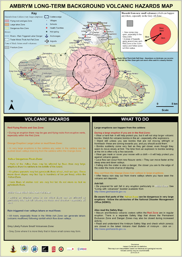
Official, Map sheet or poster
Ambrym Long-Term Background Volcanic Hazards Map
Vanuatu Meteorology & Geo-Hazards Department. (2016). Ambrym Long-Term Background Volcanic Hazards Map. Government of Vanuatu, Vanuatu Meteorology & Geo-Hazards Department, Vanuatu National Disaster Risk Management Office, New Zealand Foreign Affairs & Trade Aid Programme, GNS Science, The Vanuatu Red Cross Society, Croix Rouge Francaise, USAID.
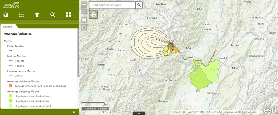
Official, Interactive web-based map
Amenaza Machín
(Machín Hazards)
Servicio Geológico Colombiano (SGC). Amenaza Machín.

Official, Figure in hazard assessment
Amenaza por corrientes de densidad piroclástica (flujos y oleadas piroclásticas)
(Hazard from pyroclastic density currents (pyroclastic flows and surges))
Figure 11 in: Méndez, R., Narváez, P., Muñoz, C. (2014). Mapa de Amenaza Volcánica del Complejo Volcánico Cumbal -- Segunda Versión. Memoria Explicativa. San Juan de Pasto: Servicio Geológico Colombiano.
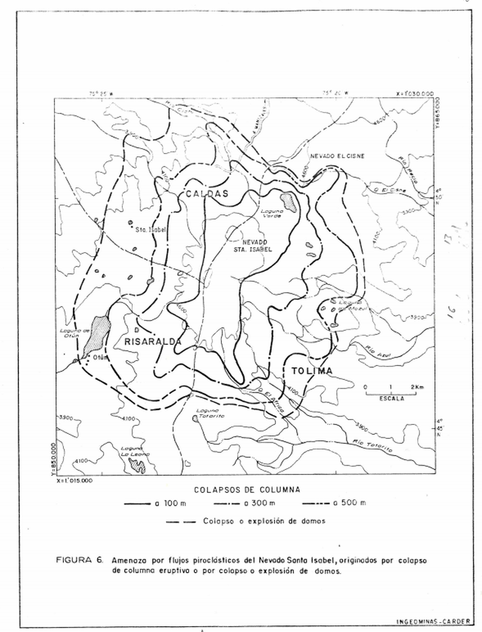
Official, Figure in hazard assessment
Amenaza por flujos piroclásticos del Nevado Santa Isabel, originados por colapso de columna eruptivo o por colapso o explosión de domos
(Pyroclastic flow hazard of Nevado Santa Isabel, caused by eruption of the eruptive column or by collapse or explosion of domes)
Figure 6 in: Instituto de Investigaciones en Geociencias, Mineria y Quimica (INGEOMINAS). (1993). Mapa Preliminar de Amenaza Volcanica Potencial Complejo de Domos Santa Isabel, Cordillera Central de Colombia. Ibague.

Official, Figure in hazard assessment
Amenaza por Flujos Piroclasticos en el Volcan Nevado del Tolima
(Hazards from Pyroclastic Flows at Nevado del Tolima Volcano)
Figure 3 in: Cepeda, H. & Murcia, A. (1988). Mapa Preliminar de Amenaza Volcanica Potencial del Nevado del Tolima, Colombia, S.A. INGEOMINAS, Instituto Nacional de Investigaciones Geologico-Mineras. Medellin.
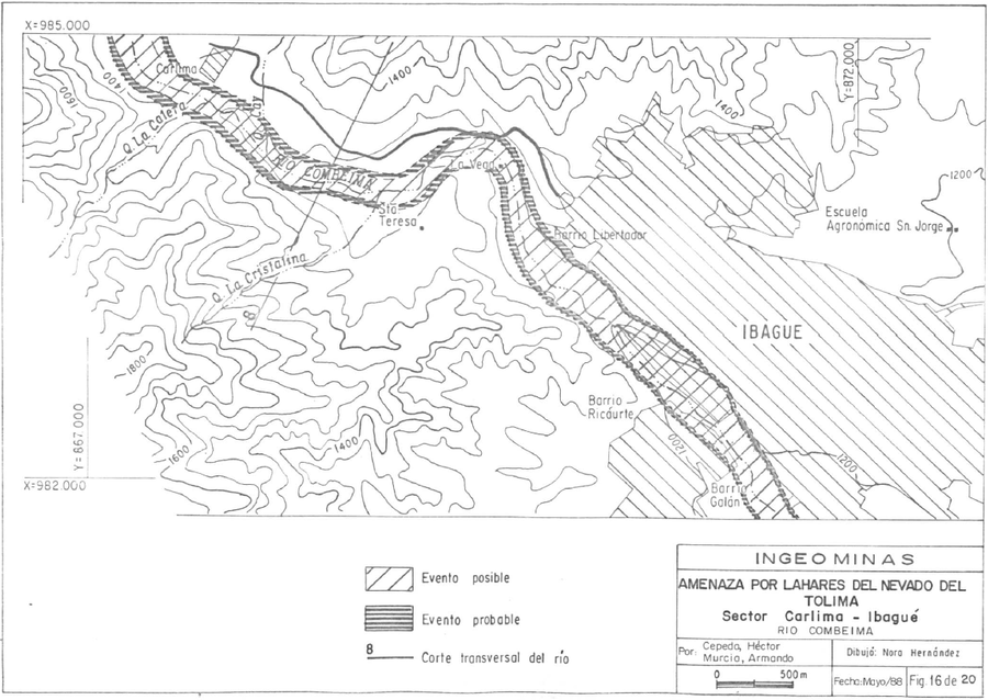
Official, Figure in hazard assessment
Amenaza por Lahares del Volcan Nevado del Tolima, Sector Carlima-Ibagué, Rio Combeima
(Hazards from Lahars of Nevado del Tolima Volcano, Carlima-Ibagué Sector, Combeima River)
Figure 16 in: Cepeda, H. & Murcia, A. (1988). Mapa Preliminar de Amenaza Volcanica Potencial del Nevado del Tolima, Colombia, S.A. Instituto Nacional de Investigaciones Geologico-Mineras (INGEOMINAS). Medellin.