
Advanced Search for Maps
Showing 61-70 of 553
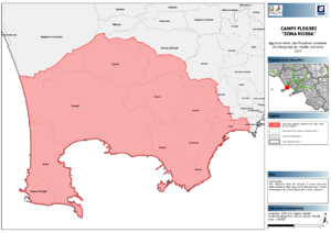
Official, Map sheet or poster
Campi Flegrei "Zona Rossa"
(Campi Flegrei "Red Zone")
Dipartimento della Protezione Civile. (2014). Campi Flegrei "Zona Rossa" - Aggiornamento Pianificazione Nazionale di Emergenza per Rischio Vulcanico.
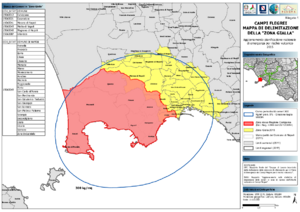
Official, Map sheet or poster
Campi Flegrei Mappa di Delimitazione della "Zona Gialla"
(Campi Flegrei Delimitation Map of the "Yellow Zone")
Dipartimento della Protezione Civile. (2015). Campi Flegrei Mappa di Delimitazione della "Zona Gialla" - Aggiornamento Pianificazione Nazionale di Emergenza per Rischio Vulcanico.
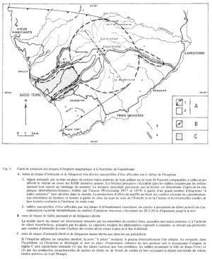
Figure in a journal article
Carte de zonation des risques d'éruption magmatique à la Soufrière de Guadeloupe
(Zonation map of magmatic eruption risks at Soufrière in Guadeloupe)
Figure 5 in: Westercamp, D. (1981). Cartographie du risque volcanique a la soufriere de guadeloupe: Retrospective et tendance actuelle. Bulletin of the International Association of Engineering Geology-Bulletin de l'Association Internationale de Géologie de l'Ingénieur, 23(1), p. 25-32. https://doi.org/10.1007/BF02594723
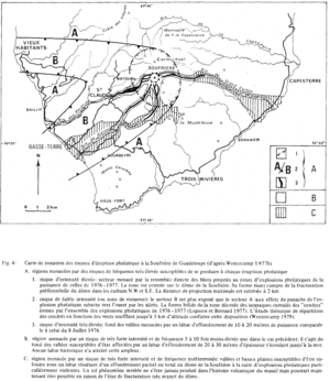
Figure in a journal article
Carte de zonation des risques d'éruption phréatique à la Soufrière de Guadeloupe (d'après Westercamp 1977b)
(Zonation map of phreatic eruption risks at Soufrière in Guadeloupe (from Westercamp 1977b))
Figure 4 in: Westercamp, D. (1981). Cartographie du risque volcanique a la soufriere de guadeloupe: Retrospective et tendance actuelle. Bulletin of the International Association of Engineering Geology-Bulletin de l'Association Internationale de Géologie de l'Ingénieur, 23(1), p. 25-32. https://doi.org/10.1007/BF02594723
Official, Insert/poster-size map with accompanying report
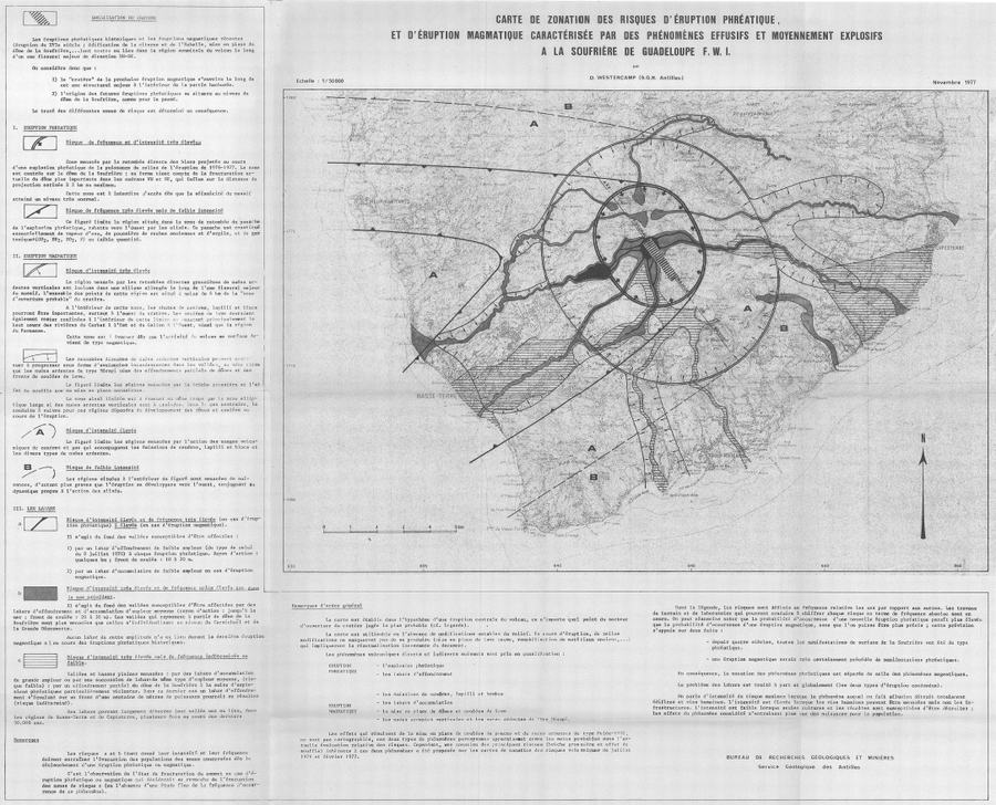
Carte de Zonation des Risques d'Éruption Phréatique, et d'Éruption Magmatique Caractérisée par des Phénomènes Effusifs et Moyennement Explosifs à la Soufrière de Guadeloupe F.W.I.
(Map of Risk of Phreatic Eruption, and Magmatic Eruption Characterized by Effusive and Moderately Explosive Phenomena at Soufrière de Guadeloupe F.W.I.)
Insert in: Westercamp, D. (1977) Levés géologiques, évaluation et zonation des risques volcaniques à la Soufrière de Guadeloupe F. W. I. (Rapport de mission) Mai-Juin 1977. Délégation Générale a la Recherche Scientifique et Technique. 77 Ant 29
Official, Map sheet or poster
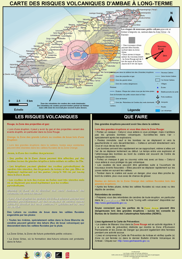
Carte des Risques Volcaniques d'Ambae à Long-terme
(Ambae Long-Term Background Volcanic Hazards Map)
Vanuatu Meteorology & Geo-Hazards Department. (2019). Carte des Risques Volcaniques d'Ambae à Long-terme. Government of Vanuatu, Vanuatu Meteorology & Geo-Hazards Department, Vanuatu National Disaster Risk Management Office, New Zealand Foreign Affairs & Trade Aid Programme, GNS Science.
Official, Map sheet or poster
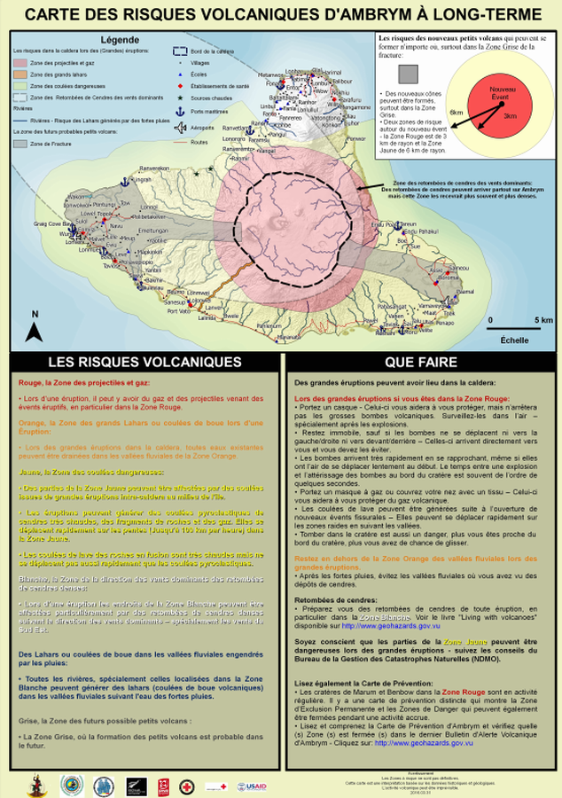
Carte des Risques Volcaniques d'Ambrym à Long-terme
(Ambrym Long-Term Background Volcanic Hazards Map)
Vanuatu Meteorology & Geo-Hazards Department. (2016). Carte des Risques Volcaniques d'Ambrym à Long-terme. Government of Vanuatu, Vanuatu Meteorology & Geo-Hazards Department, Vanuatu National Disaster Risk Management Office, New Zealand Foreign Affairs & Trade Aid Programme, GNS Science, The Vanuatu Red Cross Society, Croix Rouge Francaise, USAID.
Official, Map sheet or poster
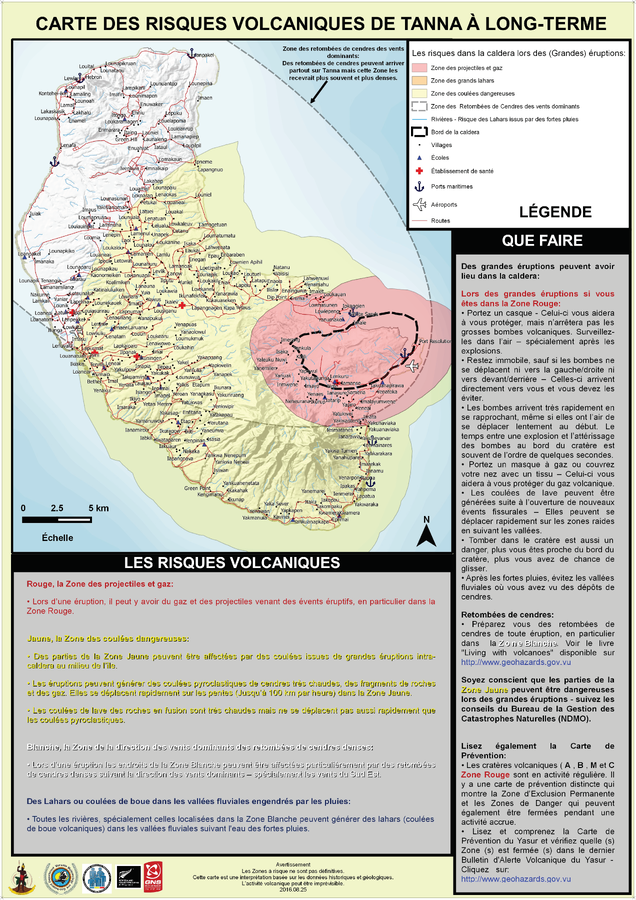
Carte des Risques Volcaniques de Tanna à Long-Terme
(Tanna Long-Term Background Volcanic Hazards Map)
Vanuatu Meteorology & Geo-Hazards Department. (2016). Carte des Risques Volcaniques de Tanna à Long-Terme. Government of Vanuatu, Vanuatu Meteorology & Geo-Hazards Department, Vanuatu National Disaster Risk Management Office, New Zealand Foreign Affairs & Trade Aid Programme, GNS Science.
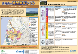
Official, Flyer, brochure, short fact-sheet, or handout
Chokaisan Volcanic Alert Levels
Japan Meteorological Agency. (2018). Chokaisan Volcanic Alert Levels. Volcano Monitoring and Warning Center, Volcano Division, Earthquake and Volcano Department.
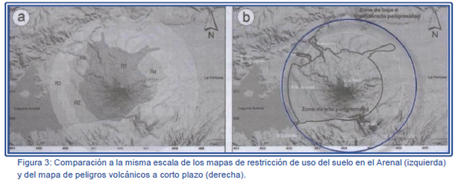
Figure in a journal article
Comparación a la misma escala de los mapas de restricción de uso del suelo en el Arenal (izquierda) y del mapa de peligros volcánicos a corto plazo (derecha).
(Comparison at the same scale of the Arenal land use restriction maps (left) and the short-term volcanic hazard map (right).)
Figure 3 in: Soto, G.J. & Sjöbohm, L. (2007). Los Peligros volcánicos del Arenal. En torno a la Prevencion. Revista No. 4, Junio 2007. Comisión Nacional de Prevención de Riesgos y Atención de Emergencias (CNE).