
Advanced Search for Maps
Showing 31-40 of 553
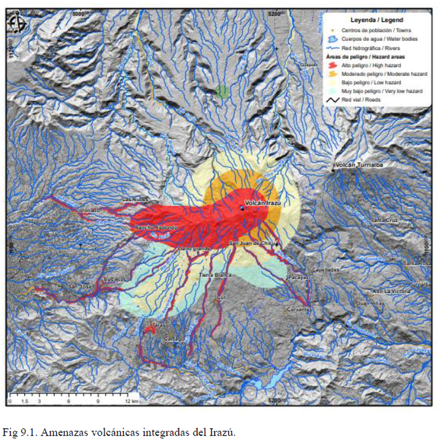
Official, Figure in hazard assessment
Amenazas volcánicas integradas del Irazú
(Integrated volcanic hazards of Irazú)
Figure 9.1 in: Alvarado, G.E., Campos-Durán, D., Brenes-André, J., Alpízar, Y., Núñez, S., Esquivel, L., Sibaja, J.P. & Fallas, B. (2021). Peligro Volcánico del Irazú, Costa Rica. Comisión Nacional de Prevención de Riesgos y Atención de Emergencias (CNE). Deciembre 2021.
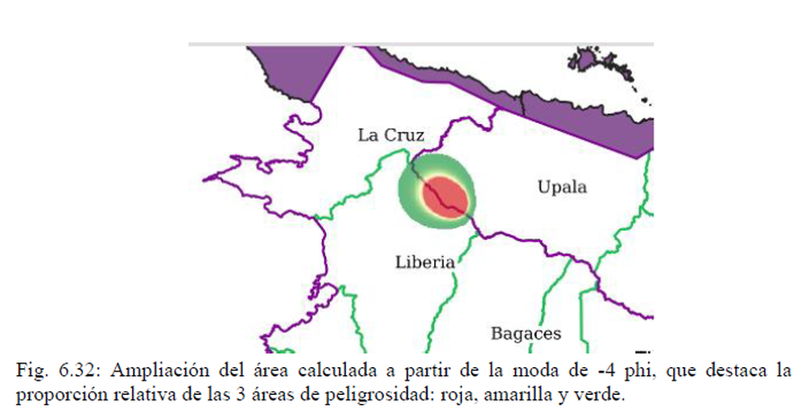
Official, Figure in hazard assessment
Ampliación del área calculada a partir de la moda de -4 phi, que destaca la proporción relativa de las 3 áreas de peligrosidad: roja, amarilla y verde
(Magnification of the area calculated from the -4 phi mode, highlighting the relative proportion of the 3 hazard areas: red, yellow and green)
Figure 6.32 in: Alvarado, G.E., Brenes-André, J., Venegas, L., Alpízar, Y., Núñez, S., Sánchez, M., Abarca, K., Abarca, J., Báez, W.A., Sibaja, J.P., Esquivel, L., & Arcia, T. (2022). Análisis del Peligro Volcánico del Rincón de la Vieja, Costa Rica. Instituto Costarricense de Electricidad (ICE). Setiembre 2022.
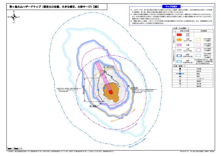
Official, Map sheet or poster
Aogashima volcanic hazard map (assumed crater position, volcanic blocks, pyroclastic surge)
Aogashima Volcano Disaster Prevention Council. (2017). Aogashima volcanic hazard map. Disaster Prevention Division, Bureau of General Affairs, Tokyo Metropolitan Government.
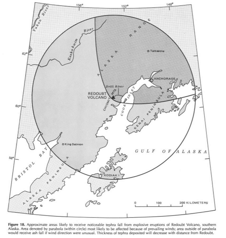
Official, Figure in hazard assessment
Approximate areas likely to receive noticeable tephra fall from explosive eruptions of Redoubt Volcano, southern Alaska
Figure 18 in: Till, A.B., Yount, M.E., & Riehle, J.R. (1993). Redoubt Volcano, southern Alaska; a hazard assessment based on eruptive activity through 1968. U.S. Geological Survey, Bulletin 1996, 19 p., 1 plate. https://doi.org/10.3133/b1996
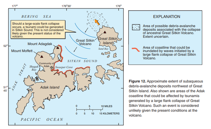
Official, Figure in hazard assessment
Approximate extent of subaqueous debris-avalanche deposits northwest of Great Sitkin Island. Also shown are areas of Adak coastline that could be affected by tsunamis generated by a large flank collapse of Great Sitkin Volcano.
Figure 12 in: Waythomas, C.F., Miller, T.P. & Nye, C.J. (2003). Preliminary volcano-hazard assessment for Great Sitkin Volcano, Alaska. U.S. Geological Survey, Open-File Report 03-112, 25 p., 1 plate. https://doi.org/10.3133/ofr03112

Official, Flyer, brochure, short fact-sheet, or handout
Are You at Risk from the Next Eruption of Mount Hood? Hazards Zonation Map
Gardner, C. A., Scott, W. E., Major, J. J., & Pierson, T. C. (2000). Mount Hood-history and hazards of Oregon's most recently active volcano. US Geological Survey, Fact Sheet 060-00 (PDF Version). https://doi.org/10.3133/fs06000
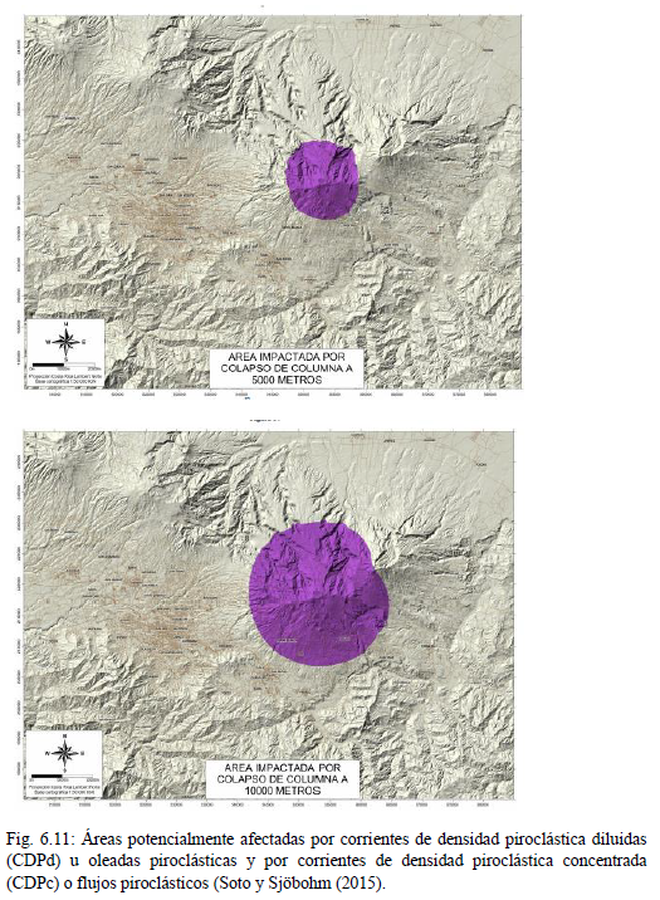
Official, Figure in hazard assessment
Area Impactada por Colapso de Columna
(Area Impacted by Column Collapse)
Figure 6.11 in: Alvarado, G.E., Campos-Durán, D., Brenes-André, J., Alpízar, Y., Núñez, S., Esquivel, L., Sibaja, J.P. & Fallas, B. (2021). Peligro Volcánico del Irazú, Costa Rica. Comisión Nacional de Prevención de Riesgos y Atención de Emergencias (CNE). Deciembre 2021. (Modified from: Soto & Sjöbohm 2015).
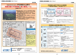
Official, Figure in hazard assessment
Area where the crater may appear and area where eruptions may affect
Page 18 in: Shizuoka Prefecture and Volcano Disaster Prevention Measure Deliberation Committee at Izu-Tobu Volcanoes. (2011). Volcano disaster prevention measure deliberation committee report at Izu-Tobu Volcanoes. Emergency Management Information Division, Shizuoka Prefecture.
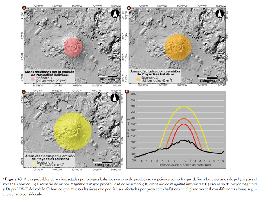
Official, Figure in hazard assessment
Áreas afectadas por la emisión de Proyectiles Balísticos
(Areas affected by the emission of Ballistic Projectiles)
Figure 48 in: Ferrés López, D., Sieron, K., González Zuccolotto, K., Constantinescu, R., Agustín Flores, J., Siebe Grabach, C., Capra Pedol, L., Connor, L., & Connor, C.B. (2019). Memoria técnica del mapa de peligros del volcán Ceboruco (Nayarit). Monografías del Instituto de Geofísica, 24.
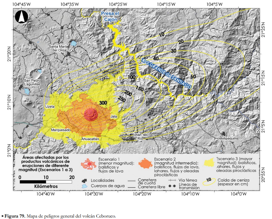
Official, Figure in hazard assessment
Áreas afectadas por los productos volcánicos de erupciones de diferente magntiud (Escenarios 1 a 3)
(Areas affected by the volcanic products of eruptions of different magnitudes (Scenarios 1 to 3))
Figure 79 in: Ferrés López, D., Sieron, K., González Zuccolotto, K., Constantinescu, R., Agustín Flores, J., Siebe Grabach, C., Capra Pedol, L., Connor, L., & Connor, C.B. (2019). Memoria técnica del mapa de peligros del volcán Ceboruco (Nayarit). Monografías del Instituto de Geofísica, 24.