
Advanced Search for Maps
Showing 41-50 of 553
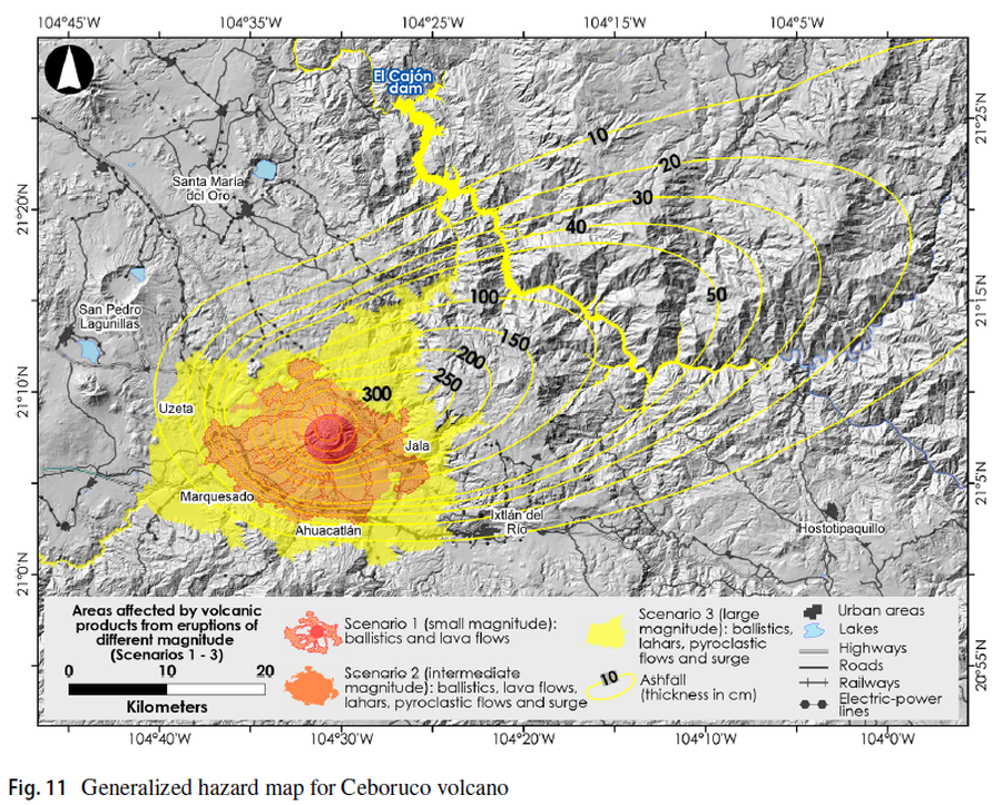
Figure in a journal article
Areas affected by volcanic products from eruptions of different magnitude (Scenarios 1-3)
Figure 11 in: Sieron, K., Ferrés, D., Siebe, C., Constantinescu, R., Capra, L., Connor, C., Connor, L., Groppelli, G. & Zuccolotto, K.G. (2019). Ceboruco hazard map: part II—modeling volcanic phenomena and construction of the general hazard map. Natural Hazards, 96(2), p. 893-933. https://doi.org/10.1007/s11069-019-03577-5
Official, Figure in hazard assessment
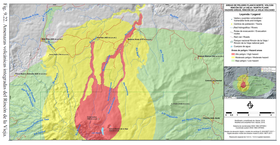
Areas de Peligro Flanco Norte, Volcán Rincón de la Vieja
(North Flank Hazard Areas, Rincón de la Vieja Volcano)
Figure 9.22 in: Alvarado, G.E., Brenes-André, J., Venegas, L., Alpízar, Y., Núñez, S., Sánchez, M., Abarca, K., Abarca, J., Báez, W.A., Sibaja, J.P., Esquivel, L., & Arcia, T. (2022). Análisis del Peligro Volcánico del Rincón de la Vieja, Costa Rica. Instituto Costarricense de Electricidad (ICE). Setiembre 2022.
Official, Insert/poster-size map with accompanying report
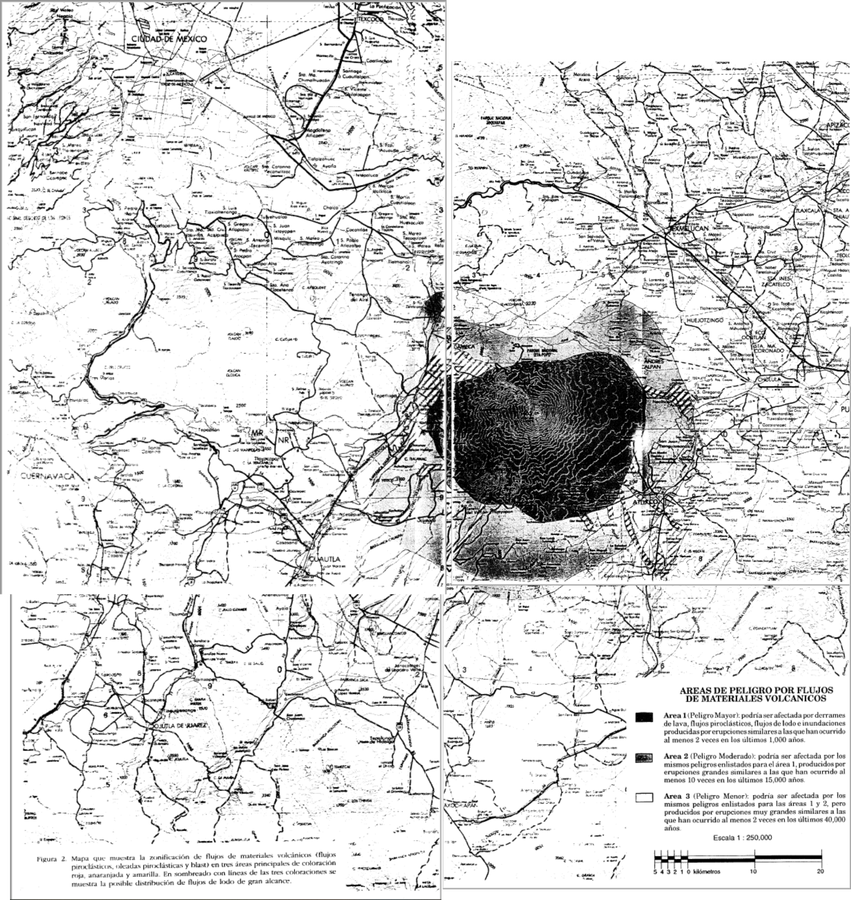
Areas de Peligro por Flujos de Materiales Volcanicos
(Hazard Areas for Flows of Volcanic Materials)
Figure 2 in: Macías J.L., Carrasco, G. Siebe, C. (1995). Zonificación de peligros volcánicos del Popocatepetl. Capitulo III Riesgos y Mapeo.
Official, Figure in hazard assessment
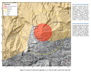
Áreas de restricción sugeridas a 2 y 5 km de radio a partir del cráter SW
(Suggested restriction areas 2 and 5 km radius from SW crater)
Figure 97 in: Soto, G.J. (2012). Preparación de mapas de peligros volcánicos y restricción de uso de la tierra en el volcán Turrialba. FUNDEVI, Universidad de Costa Rica, Escuela Centroamericana de Geología. 186 p.
Official, Figure in hazard assessment
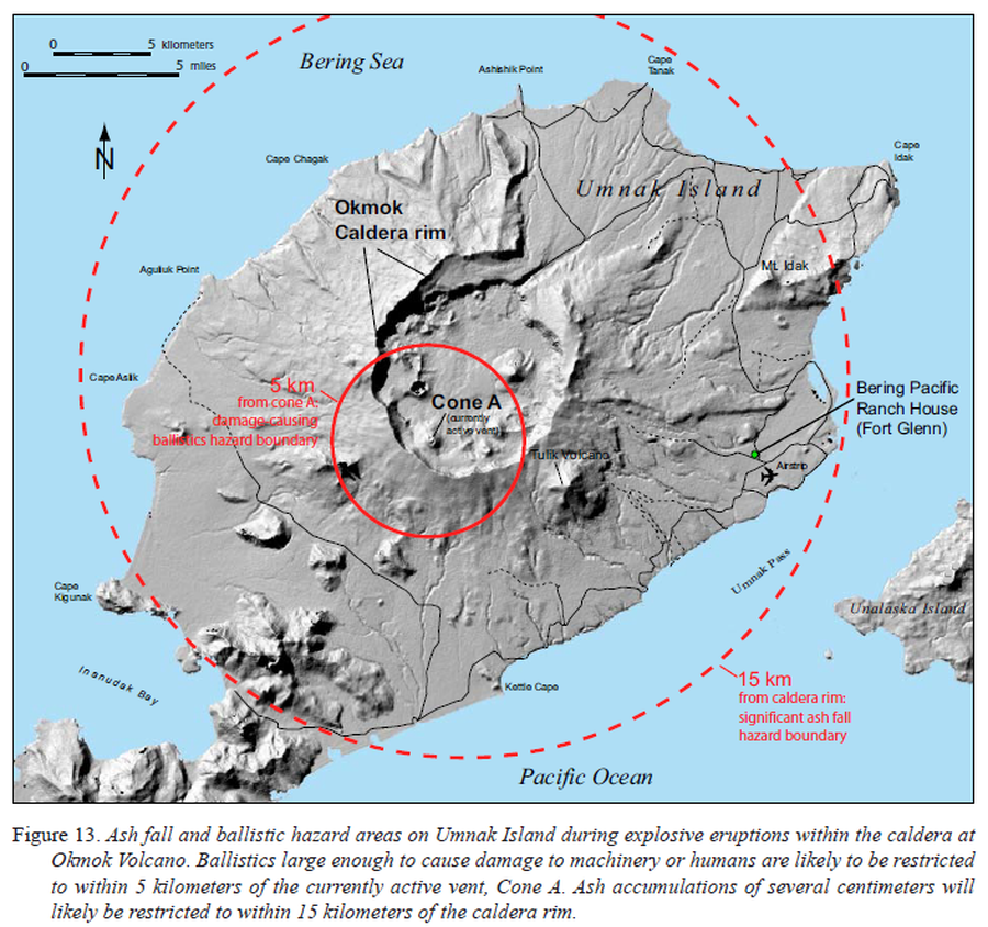
Ash fall and ballistic hazard areas on Umnak Island during explosive eruptions within the caldera at Okmok Volcano
Figure 13 in: Beget, J.E., Larsen, J.F., Neal, C.A., Nye, C.J., & Schaefer, J.R. (2005). Preliminary volcano-hazard assessment for Okmok Volcano, Umnak Island, Alaska. Department of Natural Resources, Division of Geological & Geophysical Surveys (DGGS), Report of Investigation RI 2004-3, 32 p., 1 sheet, scale 1:150,000. http://doi.org/10.14509/7042
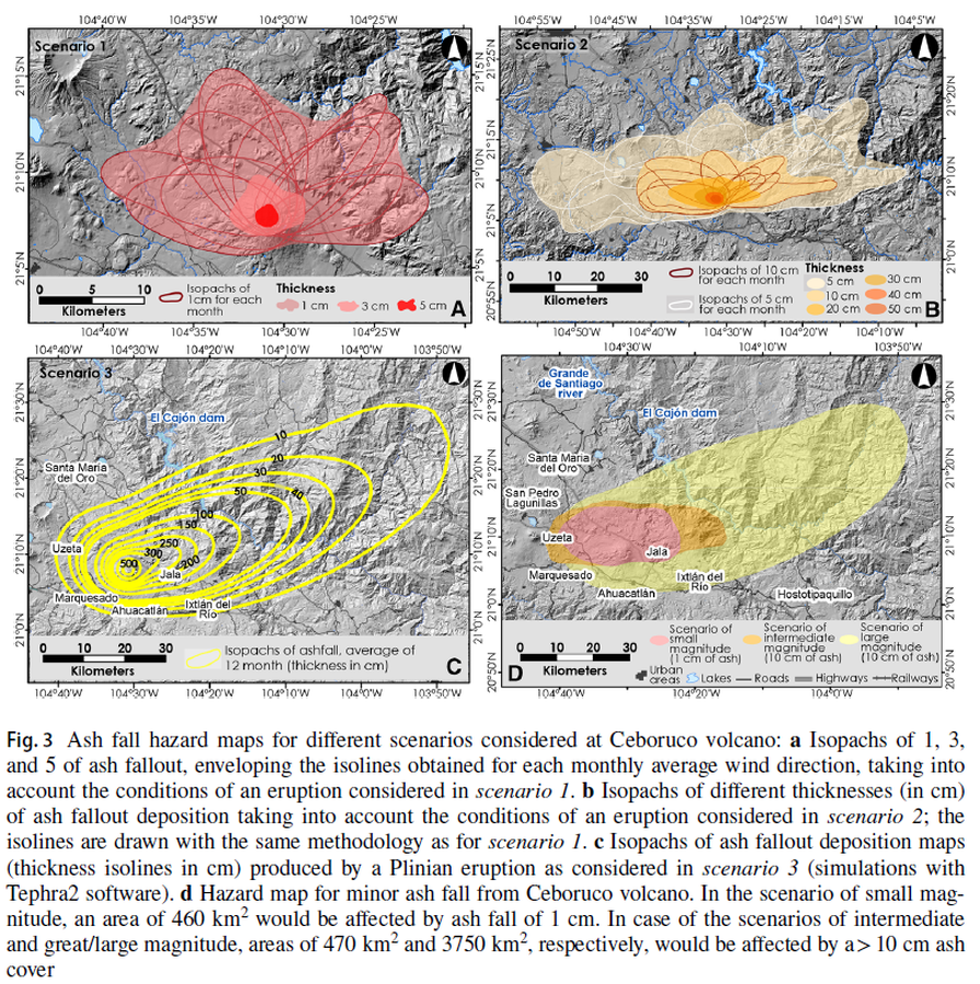
Figure in a journal article
Ash fall hazard maps for different scenarios considered at Ceboruco volcano
Figure 3 in: Sieron, K., Ferrés, D., Siebe, C., Constantinescu, R., Capra, L., Connor, C., Connor, L., Groppelli, G. & Zuccolotto, K.G. (2019). Ceboruco hazard map: part II—modeling volcanic phenomena and construction of the general hazard map. Natural Hazards, 96(2), p. 893-933. https://doi.org/10.1007/s11069-019-03577-5
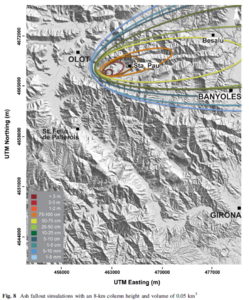
Figure in a journal article
Ash fallout simulations with an 8-km column height and volume of 0.05 km³
Figure 8 in: Bartolini, S., Bolós, X., Martí, J., Pedra, E. R., & Planagumà, L. (2015). Hazard assessment at the quaternary La Garrotxa volcanic field (NE Iberia). Natural Hazards, 78(2), 1349-1367. https://doi.org/10.1007/s11069-015-1774-y
Official, Map sheet or poster
Ashigarakami District Volcanic Disaster Prevention Map
Figure 6.3.14 in: Mt. Fuji Hazard Map Review Committee. (2004). Mt. Fuji Hazard Map Review Committee Report. June 2004. https://www.bousai.go.jp/kazan/fuji_map/pdf/report_200406.pdf
Official, Flyer, brochure, short fact-sheet, or handout
Ashoro Town Meakan-dake Disaster Prevention Map
Ashoro Town. (2000). Ashoro Town Meakan-dake Disaster Prevention Map.
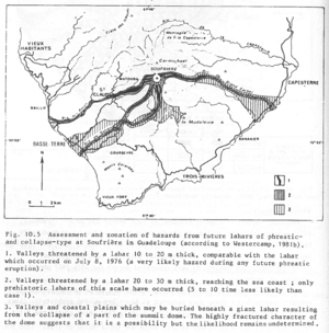
Figure in a journal article
Assessment and zonation of hazards from future lahars of phreatic and collapse-type at Soufrière in Guadeloupe (according to Westercamp, 1981b)
Figure 10.5 in: Westercamp, D. (1983). Appraisal and zonation of volcanic hazards in the French Lesser Antilles: preliminary results. In: Tazieff, H. & Sabroux, J.-C. (Eds.) Forecasting Volcanic Events, Elsevier, Amsterdam, p. 111-130.