
Advanced Search for Maps
Showing 51-60 of 553
Official, Map in a booklet, long fact-sheet, or handbook
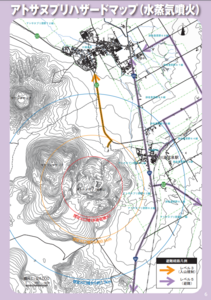
Atosanupuri Hazard Map (steam eruption)
Page 6 in: Teshikaga Town Office. (2018). Teshikaga Town Disaster Prevention Guidebook.
Official, Flyer, brochure, short fact-sheet, or handout
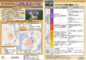
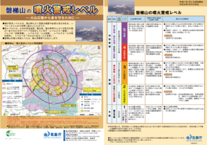
Atosanupuri Volcanic Alert Levels
Japan Meteorological Agency. (2018). Atosanupuri Volcanic Alert Levels. Volcano Monitoring and Warning Center, Volcano Division, Earthquake and Volcano Department.
Official, Flyer, brochure, short fact-sheet, or handout
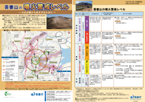
Azumayama Volcanic Alert Levels
Japan Meteorological Agency. (2019). Azumayama Volcanic Alert Levels. Volcano Monitoring and Warning Center, Volcano Division, Earthquake and Volcano Department.
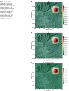
Figure in a journal article
BA hazard maps displaying the yearly mean probability of areas being impacted by BA
Figure 8 in: Sandri, L., Thouret, J. C., Constantinescu, R., Biass, S., & Tonini, R. (2014). Long-term multi-hazard assessment for El Misti volcano (Peru). Bulletin of volcanology, 76(2), 771. https://doi.org/10.1007/s00445-013-0771-9
Official, Flyer, brochure, short fact-sheet, or handout
Bandaisan Volcanic Alert Levels
Japan Meteorological Agency. (2019). Bandaisan Volcanic Alert Levels. Volcano Monitoring and Warning Center, Volcano Division, Earthquake and Volcano Department.
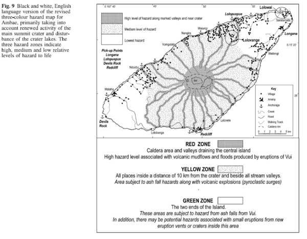
Figure in a journal article
Black and white, English language version of the revised three-colour hazard map for Ambae, primarily taking into account renewed activity of the main summit crater and disturbance of the crater lakes
Figure 9 in: Cronin, S.J., Gaylord, D.R., Charley, D., Alloway, B.V., Wallez, S., & Esau, J.W. (2004). Participatory methods of incorporating scientific with traditional knowledge for volcanic hazard management on Ambae Island, Vanuatu. Bulletin of volcanology, 66(7), p. 652-668. https://doi.org/10.1007/s00445-004-0347-9
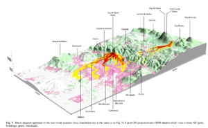
Figure in a journal article
Block diagram appraisal of the two event scenario
Figure 9 in: Latutrie, B., Andredakis, I., De Groeve, T., Harris, A. J. L., Langlois, E., de Vries, B. V. W., Saubin, E., Bilotta, G., Cappello, A., Crisci, G.M., D'ambrosio, D., Del Negro, C., Favalli, M., Fujita, E., Iovine, G., Kelfoun, K., Rongo, R., Spataro, W., Tarquini, S., Coppola, D., Ganci, G., Marchese, F., Pergola, N., & Tramutoli, V. (2016). Testing a geographical information system for damage and evacuation assessment during an effusive volcanic crisis. In: Harris, A.J.L., De Groeve, T., & Carn, S.A. (Eds.) Detecting, Modelling and Responding to Effusive Eruptions. Geological Society, London, Special Publications, 426(1), p. 649-672. https://doi.org/10.1144/SP426.19
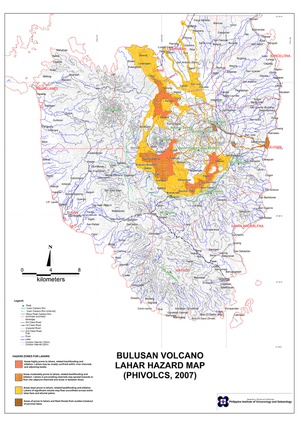
Official, Map sheet or poster
Bulusan Volcano Lahar Hazard Map
Philippine Institute of Volcanology and Seismology (PHIVOLCS). (2007). Bulusan Volcano Lahar Hazard Map.
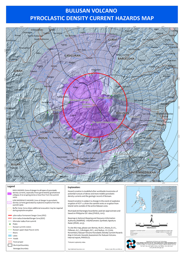
Official, Insert/poster-size map with accompanying report
Bulusan Volcano Pyroclastic Flow Hazard Map
Bornas, M.A.V., Rivera, D.J.V., Pidlaoan, A.C., Cahulogan, M.T., & Nadua, J.H. (2016). Bulusan Volcano Pyroclastic Density Current Hazard Map. in: Volcanic Hazard Assessment for Bulusan Volcano. Philippine Institute of Volcanology and Seismology (PHIVOLCS).

Official, Map sheet or poster
Bulusan Volcano Pyroclastic Flow Hazard Map
Philippine Institute of Volcanology and Seismology (PHIVOLCS). (2000). Bulusan Volcano Pyroclastic Flow Hazard Map.