
Advanced Search for Maps
Showing 31-40 of 349
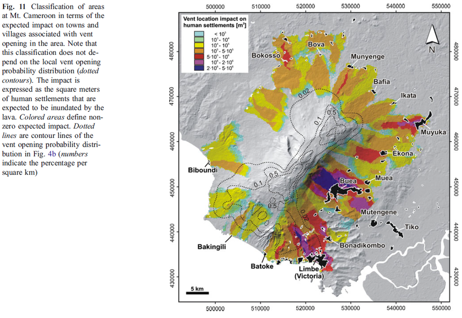
Figure in a journal article
Classification of areas at Mt. Cameroon in terms of the expected impact on towns and villages associated with vent opening in the area
Figure 11 in: Favalli, M., Tarquini, S., Papale, P., Fornaciai, A., & Boschi, E. (2012). Lava flow hazard and risk at Mt. Cameroon volcano. Bulletin of Volcanology, 74(2), 423-439. https://doi.org/10.1007/s00445-011-0540-6
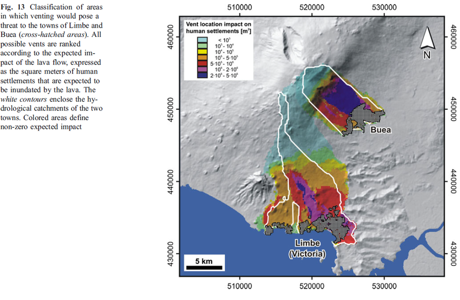
Figure in a journal article
Classification of areas in which venting would pose a threat to the towns of Limbe and Buea
Figure 13 in: Favalli, M., Tarquini, S., Papale, P., Fornaciai, A., & Boschi, E. (2012). Lava flow hazard and risk at Mt. Cameroon volcano. Bulletin of Volcanology, 74(2), 423-439. https://doi.org/10.1007/s00445-011-0540-6
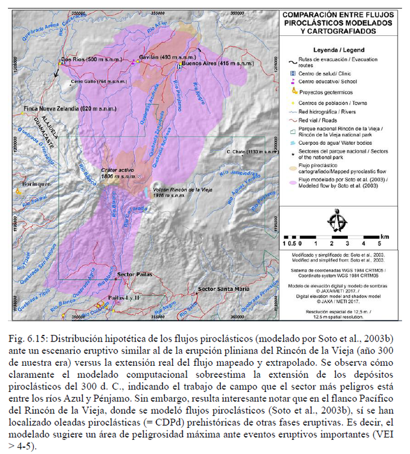
Official, Figure in hazard assessment
Comparación Entre Flujos Piroclásticos Modelados y Cartografiados
(Comparison Between Modeled and Mapped Pyroclastic Flows)
Figure 6.15 in: Alvarado, G.E., Brenes-André, J., Venegas, L., Alpízar, Y., Núñez, S., Sánchez, M., Abarca, K., Abarca, J., Báez, W.A., Sibaja, J.P., Esquivel, L., & Arcia, T. (2022). Análisis del Peligro Volcánico del Rincón de la Vieja, Costa Rica. Instituto Costarricense de Electricidad (ICE). Setiembre 2022. (Modified from: Soto et al. 2003).
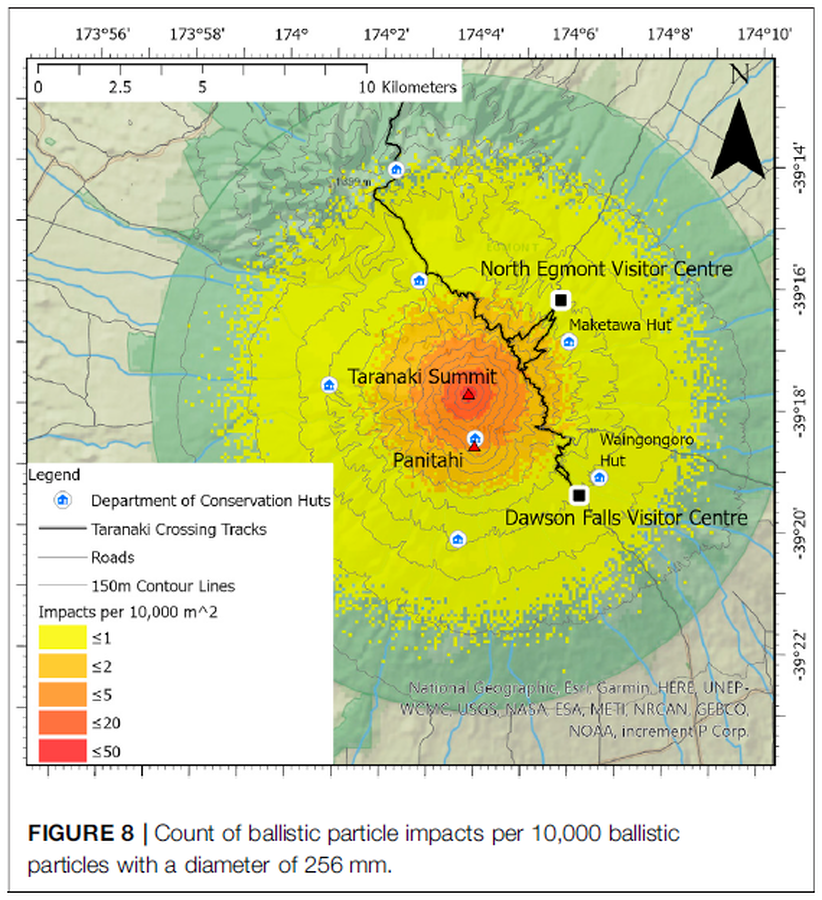
Figure in a journal article
Count of ballistic particle impacts per 10,000 ballistic particles with a diameter of 256 mm
Figure 8 in: Mead, S., Procter, J., Bebbington, M., & Rodriguez-Gomez, C. (2022). Probabilistic Volcanic Hazard Assessment for National Park Infrastructure Proximal to Taranaki Volcano (New Zealand). Frontiers in Earth Science, 435. https://doi.org/10.3389/feart.2022.832531
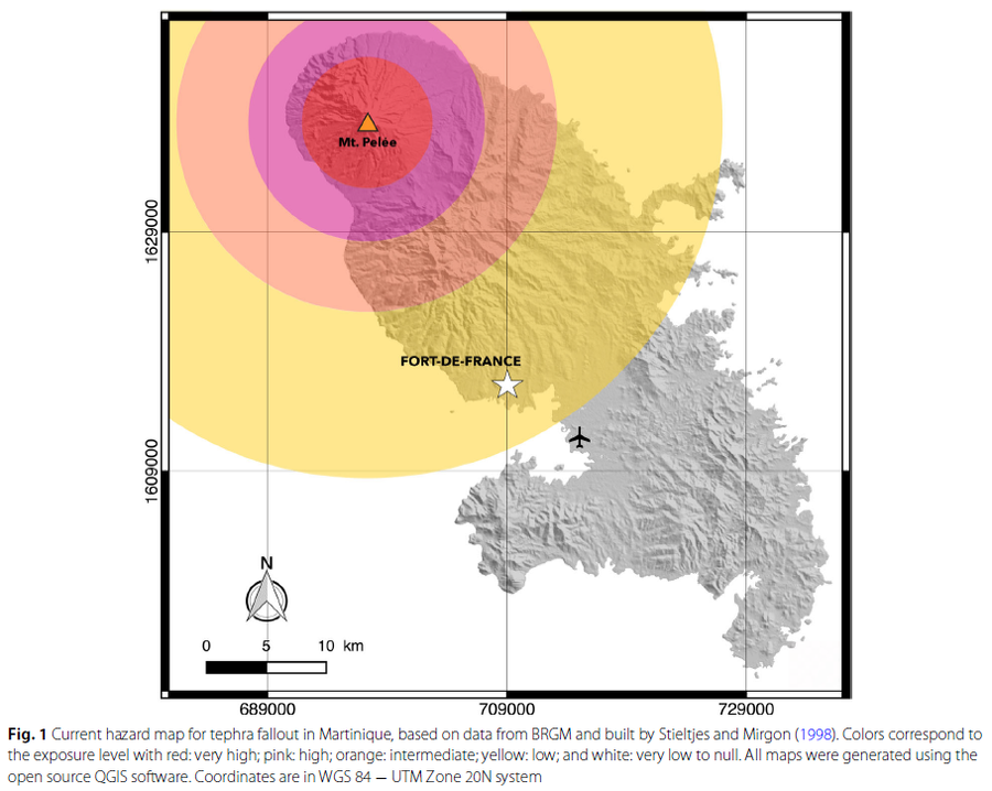
Figure in a journal article
Current hazard map for tephra fallout in Martinique
Figure 1 in: Michaud-Dubuy, A., Carazzo, G., & Kaminski, E. (2021). Volcanic hazard assessment for tephra fallout in Martinique. Journal of Applied Volcanology, 10(1), 1-20. https://doi.org/10.1186/s13617-021-00106-7. (Modified from: Stieltjes & Mirgon 1998)
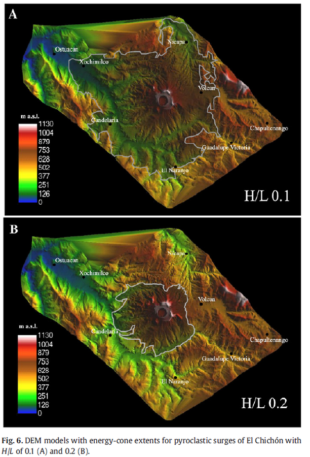
Figure in a journal article
DEM models with energy-cone extents for pyroclastic surges of El Chichón with H/L of 0.1 (A) and 0.2 (B).
Figure 6 in: Macías, J. L., Capra, L., Arce, J. L., Espíndola, J. M., García-Palomo, A., & Sheridan, M. F. (2008). Hazard map of El Chichón volcano, Chiapas, México: Constraints posed by eruptive history and computer simulations. Journal of Volcanology and Geothermal Research, 175(4), 444-458. https://doi.org/10.1016/j.jvolgeores.2008.02.023
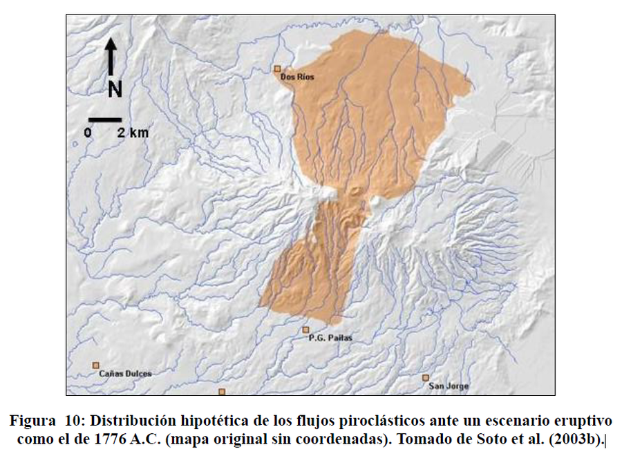
Official, Figure in hazard assessment
Distribución hipotética de los flujos piroclásticos ante un escenario eruptivo como el de 1776 A.C.
(Hypothetical distribution of pyroclastic flows in an eruptive scenario such as that of 1776 BC)
Figure 10 (in reprint) in: Soto, G.J., Alvarado, G., Goold, S., Climent, A. (2003). Evaluación del peligro y riesgo volcánico que representa el volcán Rincón de la Vieja para el Proyecto Geotérmico Las Pailas, Cordillera de Guanacaste, Costa Rica. Inf. Interno ICE, 78 p. (Reprinted in: Alpízar, Y. (2018). Mapa Preliminar de Peligros Volcánicos para el Volcán Rincón de la Vieja (Costa Rica): Descripción de un Escenario de Afectación por Lahares. Ciudad Universitaria Rodrigo Facio, Costa Rica. 160 p.)
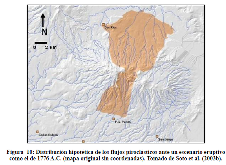
Figure in a thesis or dissertation
Distribución hipotética de los flujos piroclásticos ante un escenario eruptivo como el de 1776 A.C.
(Hypothetical distribution of pyroclastic flows in a eruptive scenario like that of 1776 B.C.)
Figure 10 in: Alpízar, Y. (2018). Mapa Preliminar de Peligros Volcánicos para el Volcán Rincón de la Vieja (Costa Rica): Descripción de un Escenario de Afectación por Lahares. Ciudad Universitaria Rodrigo Facio, Costa Rica. 160 p. (Modified from: Soto et al. 2003)
Official, Figure on website
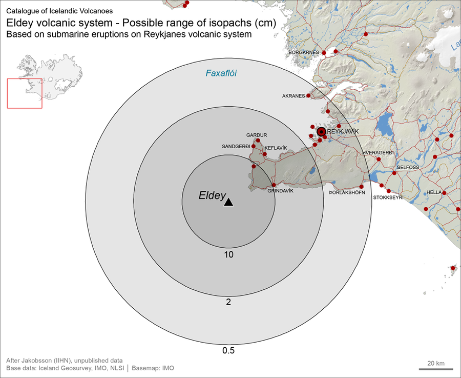
Eldey volcanic system - Possible range of isopachs (cm). Based on submarine eruptions on Reykjanes volcanic system
Larsen, G. (2019). Eldey. In: Oladottir, B., Larsen, G. & Guðmundsson, M. T. Catalogue of Icelandic Volcanoes. Iceland Meteorological Office (IMO), Univeristy of Iceland, and Civil Protection Department of the National Commissioner of the Iceland Police (CPD-NCIP). https://icelandicvolcanos.is//index.html (Simplified from: S.P. Jakobsson Unpublished data)
Eldey, Iceland
Official, Interactive web-based map
Eldey, possible range of isopachs based on submarine eruptions on Reykjanes volcanic system (cm) - After Jakobsson S.P. (Unpublished material)
Larsen, G. (2019). Eldey. In: Oladottir, B., Larsen, G. & Guðmundsson, M. T. Catalogue of Icelandic Volcanoes. Iceland Meteorological Office (IMO), Univeristy of Iceland, and Civil Protection Department of the National Commissioner of the Iceland Police (CPD-NCIP). (Simplified from: S.P. Jakobsson Unpublished data)