
Advanced Search for Maps
Showing 61-70 of 349
Official, Insert/poster-size map with accompanying report
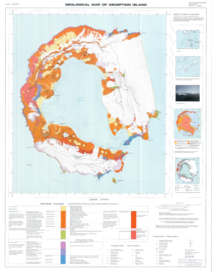
Geologic Map of Deception Island
Sheet 6-A in: Smellie, J.L., López-Martínez, J., Headland, R.K., Hernández-Cifuentes, F., Maestro, A., Millar, I.L., Rey, J., Serrano, E., Somoza, L., & Thomson, J.W. (2002). Geology and geomorphology of Deception Island. Cambridge, British Antarctic Survey, 77 p. (BAS Geomap Series, Sheets 6A and 6B).
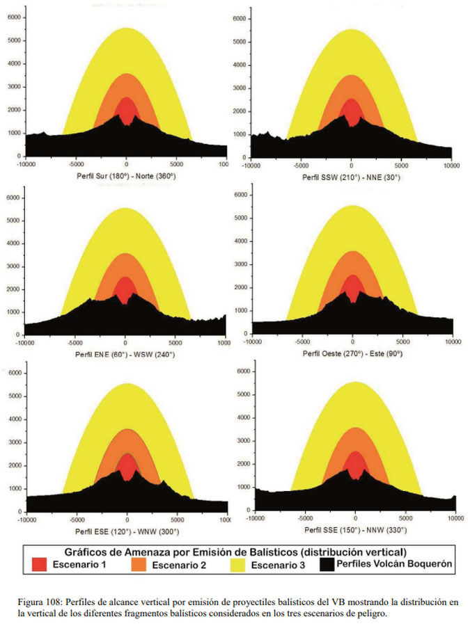
Figure in a thesis or dissertation
Gráficos de Amenaza por Emisión de Balísticos (distribución vertical)
(Ballistic Emission Threat Charts (vertical distribution))
Figure 108 in: Ferrés López, M.D. (2014). Estratigrafía, Geología y Evaluación de Peligros Volcánicos del Complejo Volcánico de San Salvador (El Salvador). Doctoral Thesis, Universidad Autónoma de México, México.
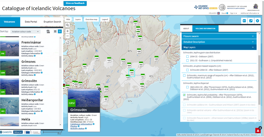
Official, Interactive web-based map
Grímsvötn, tephra fall probability - After Thorarinsson (1974), Gudmundsson et al. (2004), Oddsson et al. (2012), Gudmundsson et al. (2013)
Guðmundsson, M.T. & Larsen, G. (2019). Grímsvötn. In: Oladottir, B., Larsen, G. & Guðmundsson, M. T. Catalogue of Icelandic Volcanoes. Iceland Meteorological Office (IMO), Univeristy of Iceland, and Civil Protection Department of the National Commissioner of the Iceland Police (CPD-NCIP). (Simplified from: Thorarinsson 1974, Gudmundsson et al. 2004, Oddsson et al. 2012, Gudmundsson et al. 2013)
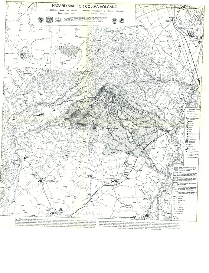
Official, Figure in hazard assessment
Hazard Map for Colima Volcano
Figure 6 in: Martin Del Pozzo, A. L., Sheridan, M., Barrera, D., Lugo Hubp, J., & Vázquez Selem, L. (1995). Potential hazards from Colima volcano, Mexico. Geofisica Internacional, 34(4), 363–376. Recuperado a partir de http://132.248.182.214/index.php/RGI/article/view/1422 (Modified version of: Martin Del Pozzo et al. 1995)
Official, Map sheet or poster
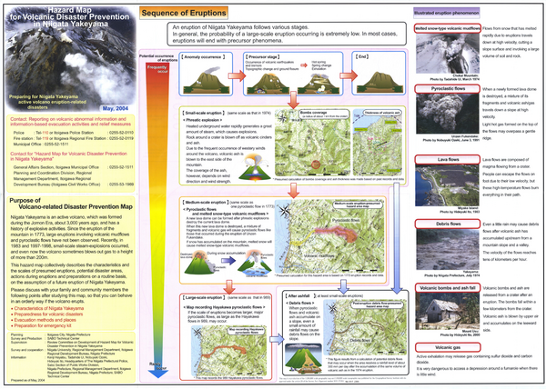
Hazard Map for Volcanic Disaster Prevention in Niigata Yakekama
Niigata Prefecture & Itoigawa City. (2004). Hazard Map for Volcanic Disaster Prevention in Niigata Yakayama.
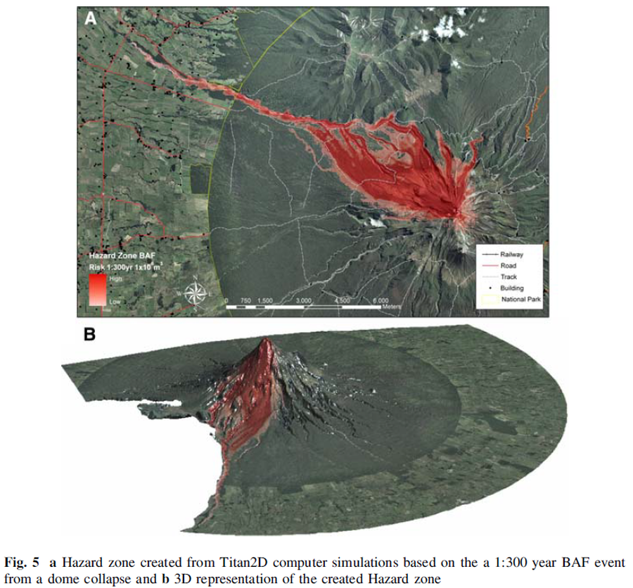
Figure in a journal article
Hazard zone created from Titan2D computer simulations based on the 1:300 year BAF event from a dome collapse and 3D representation of the created Hazard zone
Figure 5 in: Procter, J. N., Cronin, S. J., Platz, T., Patra, A., Dalbey, K., Sheridan, M., & Neall, V. (2010). Mapping block-and-ash flow hazards based on Titan 2D simulations: a case study from Mt. Taranaki, NZ. Natural Hazards, 53, 483-501.
Official, Figure in hazard assessment
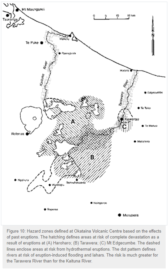
Hazard zones defined at Okataina Volcanic Centre based on the effects of past eruptions
Figure 10 in: Nairn, I.A. (1993). Volcanic hazards at Okataina Centre. 3rd ed. Ministry of Civil Defence, Palmerston North, NZ. Volcanic hazards information series 2. 29 p. Reproduced on website: https://www.gns.cri.nz/Home/Learning/Science-Topics/Volcanoes/New-Zealand-Volcanoes/Volcano-Geology-and-Hazards/Okataina-Volcanic-Centre-Geology

Official, Map in a booklet, long fact-sheet, or handbook
Hazard zones for debris flows, lahars, lava flows, and pyroclastic flows from Mount Rainier
Page 3 in: Driedger, C.L. & Scott, W.E. (2008). Mount Rainier: living safely with a volcano in your backyard. U.S. Geological Survey, Fact Sheet 2008-3062, 4 p. https://doi.org/10.3133/fs20083062
Official, Figure in a journal article
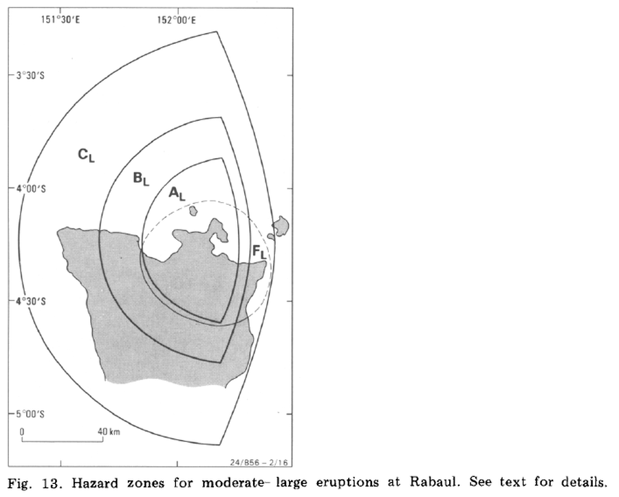
Hazard zones for moderate-large eruptions at Rabaul
Figure 13 in: McKee, C. O., Johnson, R. W., Lowenstein, P. L., Riley, S. J., Blong, R. J., De Saint Ours, P., & Talai, B. (1985). Rabaul caldera, Papua New Guinea: volcanic hazards, surveillance, and eruption contingency planning. Journal of Volcanology and Geothermal Research, 23(3-4), p. 195-237. https://doi.org/10.1016/0377-0273(85)90035-6
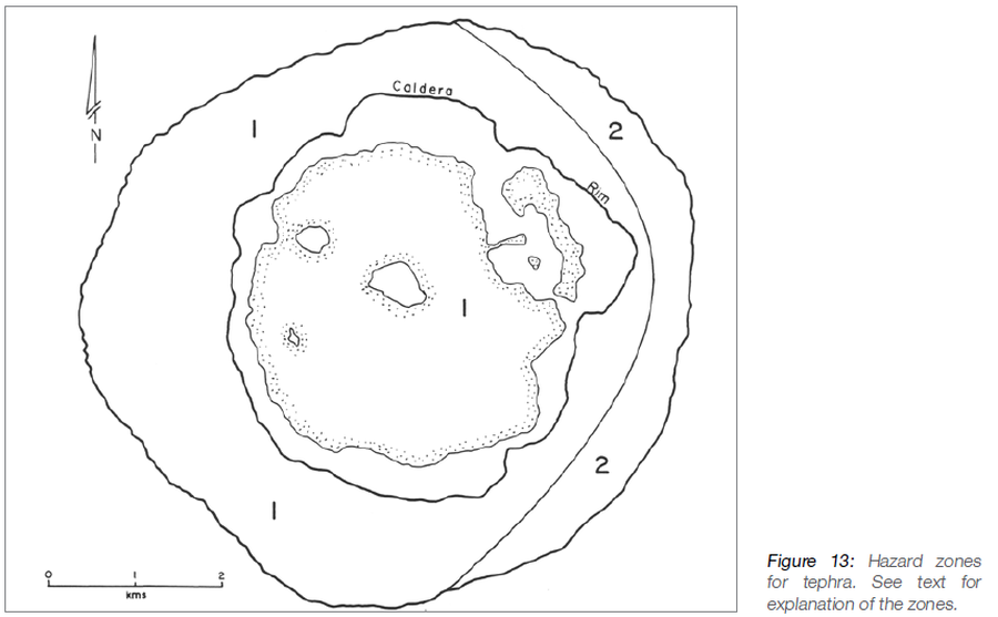
Official, Figure in hazard assessment
Hazard zones for tephra
Figure 13 in: Taylor, P.W. (2016). Niuafo’ou, Tonga: Volcanic Hazards and the Risk From Future Activity. In: Taylor, P.W. (Ed.) Volcanic Hazards and Emergency Management in the Southwest Pacific, SPC Technical Bulletin, SPC00017, p. 132-150