
Advanced Search for Maps
Showing 41-50 of 213
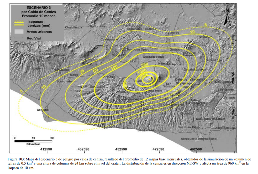
Figure in a thesis or dissertation
Escenario 3 por Caida de Ceniza Promedio 12 Meses
(Scenario 3 for Average Ash Fall 12 Months)
Figure 103 in: Ferrés López, M.D. (2014). Estratigrafía, Geología y Evaluación de Peligros Volcánicos del Complejo Volcánico de San Salvador (El Salvador). Doctoral Thesis, Universidad Autónoma de México, México.
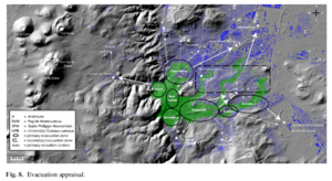
Figure in a journal article
Evacuation appraisal
Figure 8 in: Latutrie, B., Andredakis, I., De Groeve, T., Harris, A. J. L., Langlois, E., de Vries, B. V. W., Saubin, E., Bilotta, G., Cappello, A., Crisci, G.M., D'ambrosio, D., Del Negro, C., Favalli, M., Fujita, E., Iovine, G., Kelfoun, K., Rongo, R., Spataro, W., Tarquini, S., Coppola, D., Ganci, G., Marchese, F., Pergola, N., & Tramutoli, V. (2016). Testing a geographical information system for damage and evacuation assessment during an effusive volcanic crisis. In: Harris, A.J.L., De Groeve, T., & Carn, S.A. (Eds.) Detecting, Modelling and Responding to Effusive Eruptions. Geological Society, London, Special Publications, 426(1), p. 649-672. https://doi.org/10.1144/SP426.19
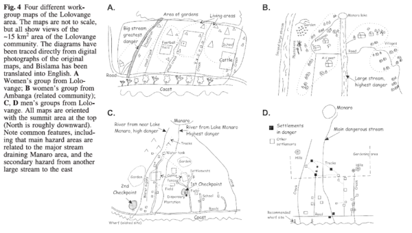
Figure in a journal article
Four different workgroup maps of the Lolovange area
Figure 4 in: Cronin, S.J., Gaylord, D.R., Charley, D., Alloway, B.V., Wallez, S., & Esau, J.W. (2004). Participatory methods of incorporating scientific with traditional knowledge for volcanic hazard management on Ambae Island, Vanuatu. Bulletin of volcanology, 66(7), p. 652-668. https://doi.org/10.1007/s00445-004-0347-9
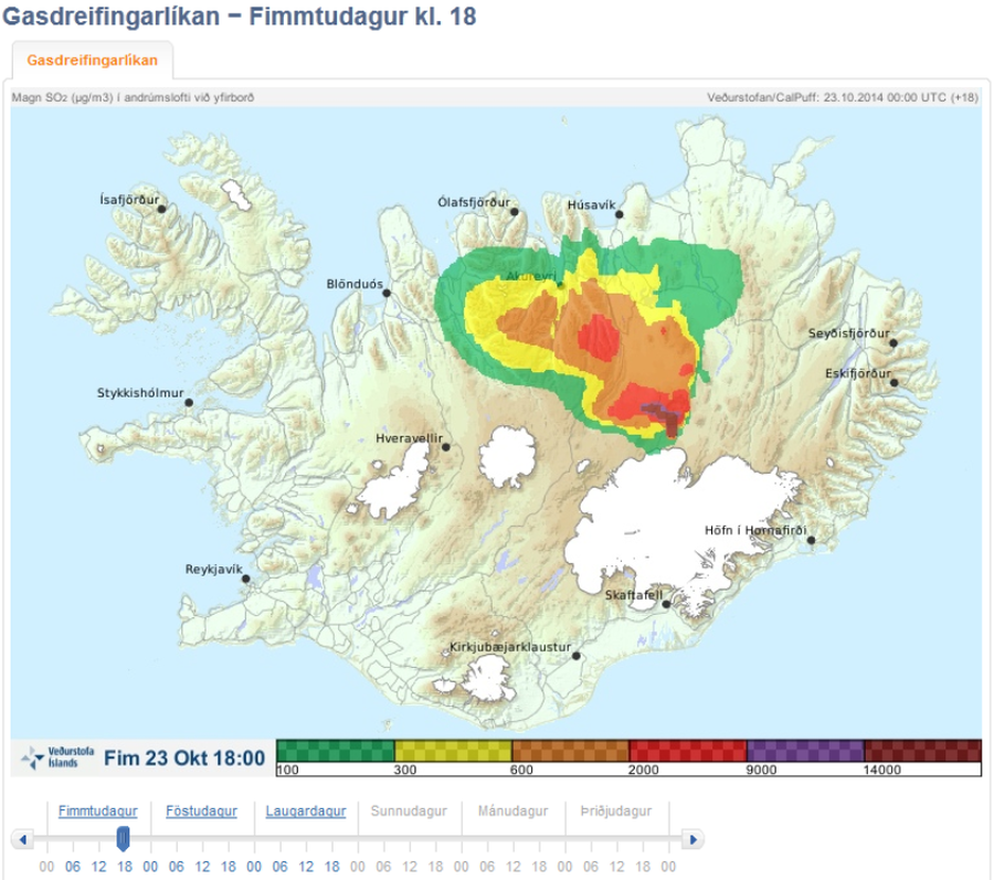
Official, Map in an information statement
Gasdreifingarspá. Magn SO2 í andrúmslofti við yfirborð. Fim 23 Okt 18:00
(Gas distribution forecast. Amount of SO2 in atmosphere at surface. Thu 23 Oct 18:00)
Iceland Meteorological Office (IMO). (2014). Gasdreifingarspá. Magn SO2 í andrúmslofti við yfirborð. Fim 23 Okt 18:00
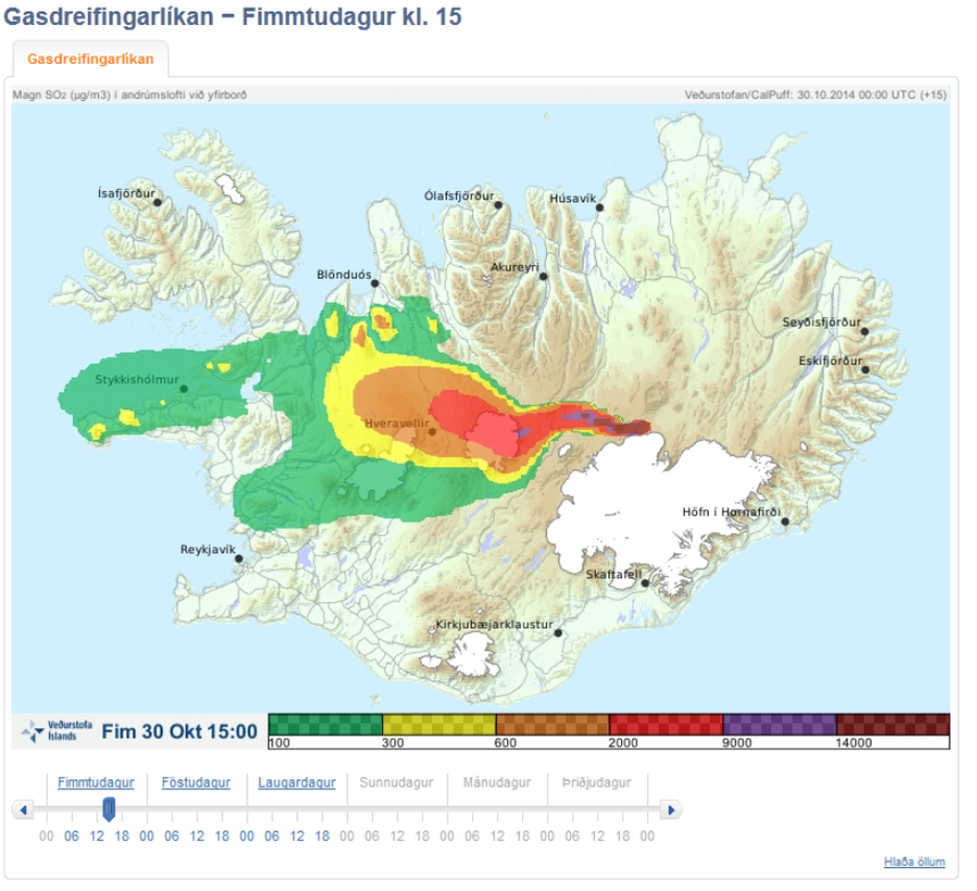
Official, Map in an information statement
Gasdreifingarspá. Magn SO2 í andrúmslofti við yfirborð. Fim 30 Okt 15:00
(Gasdreifingarspá. Amount of SO2 in atmosphere at surface. Thu Oct 30 15:00)
Iceland Meteorological Office (IMO). (2014). Gasdreifingarspá. Magn SO2 í andrúmslofti við yfirborð. Fim 30 Okt 15:00
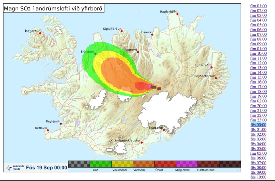
Official, Map in an information statement
Gasdreifingarspá. Magn SO2 í andrúmslofti við yfirborð. Fös 19 Sept 00:00
(Gas distribution forecast. Amount of SO2 in atmosphere at surface. Fri 19 Sept 00:00)
Iceland Meteorological Office (IMO). (2014). Gasdreifingarspá. Magn SO2 í andrúmslofti við yfirborð. Fös 19 Sept 00:00
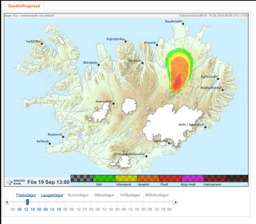
Official, Map in an information statement
Gasdreifingarspá. Magn SO2 í andrúmslofti við yfirborð. Fös 19 Sept 13:00
(Gas distribution forecast. Amount of SO2 in atmosphere at surface. Fri 19 Sept 13:00)
Iceland Meteorological Office (IMO). (2014). Gasdreifingarspá. Magn SO2 í andrúmslofti við yfirborð. Fös 19 Sept 13:00
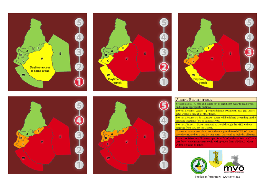
Official, Figure on website
Hazard Level System
Montserrat Volcano Observatory (MVO). (Year Unknown). Hazard Level System. Soufrière Hills Volcano, Monsterrat, Hazards Level System.
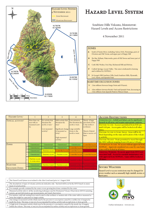
Official, Figure on website
Hazard Level System Soufriere Hills Volcano, Monsterrat: Hazard Levels and Access Restrictions 4 November 2011
Montserrat Volcano Observatory (MVO). (2011) Hazard Level System. Soufriere Hills Volcano, Monsterrat: Hazard Levels and Access Restrictions 4 November 2011. http://www.mvo.ms/pub/Hazard_Level_System/HLS-20111104.pdf

Official, Figure on website
Hazard Level: 1
Montserrat Volcano Observatory (MVO). (Year Unknown). Hazard Level. Retrieved 29 March, 2022, from http://www.mvo.ms/