
Advanced Search for Maps
Showing 51-60 of 213
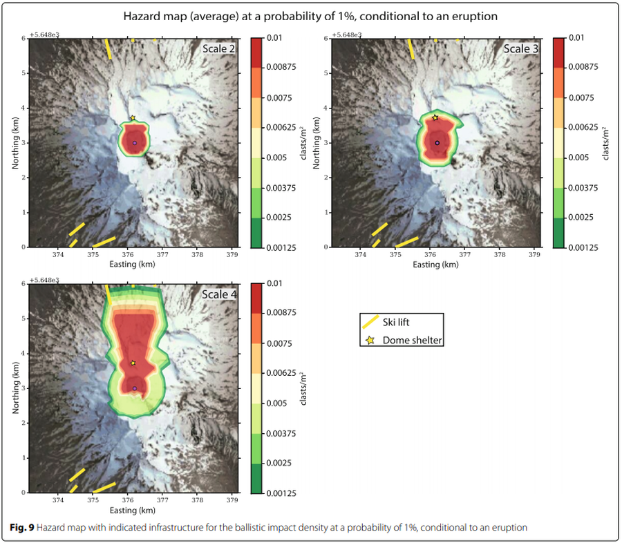
Figure in a journal article
Hazard map (average) at a probability of 1% conditional to an eruption
Figure 9 in: Strehlow, K., Sandri, L., Gottsmann, J. H., Kilgour, G., Rust, A. C., & Tonini, R. (2017). Phreatic eruptions at crater lakes: occurrence statistics and probabilistic hazard forecast. Journal of Applied Volcanology, 6(1), 4. https://doi.org/10.1186/s13617-016-0053-2
Official, Unknown format
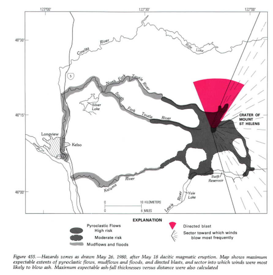
Hazard zones as drawn May 26, 1980, after May 18 dacitic magmatic eruption.
Figure 455 in: Miller, C.D., Mullineaux, D.R. & Crandell, D.R. (1981). Hazards assessments at Mount St. Helens. In: Lipman, P. W. & Mullineaux, D. R. (Eds.) The 1980 eruptions of Mount St. Helens, Washington. U.S. Geological Survey, Professional Paper 1250, p. 789-802. https://doi.org/10.3133/pp1250
Official, Figure on website
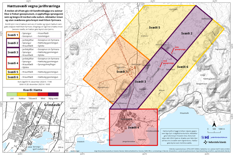
Hættusvæði vegna jarðhræringa
(Danger zone due to earthquakes)
Icelandic Meteorological Office (IMO). (2023). Hættusvæði vegna jarðhræringa, 19. desember 2023.
Official, Figure on website
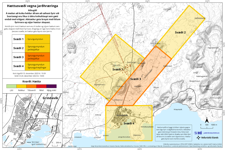
Hættusvæði vegna jarðhræringa
(Danger zone due to earthquakes)
Icelandic Meteorological Office (IMO). (2023). Hættusvæði vegna jarðhræringa, 13. desember 2023.
Official, Figure on website
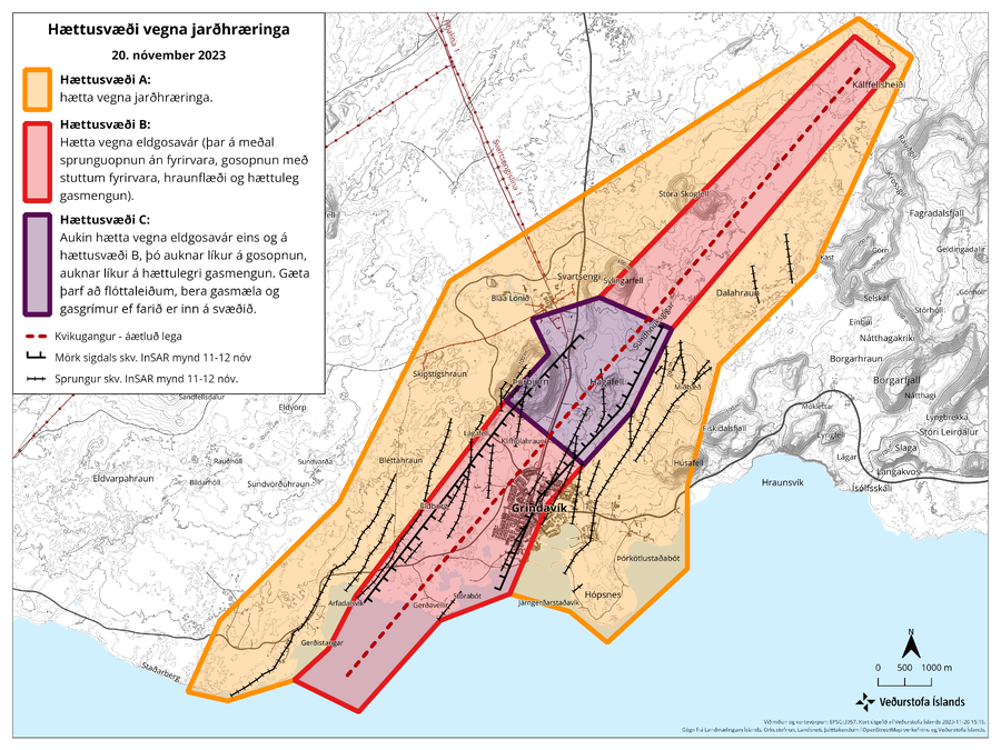
Hættusvæði vegna jarðhræringa, 20. nóvember 2023
(Earthquake hazard zone, November 20, 2023)
Icelandic Meteorological Office (IMO). (2023). Hættusvæði vegna jarðhræringa, 20. nóvember 2023.
Official, Figure on website
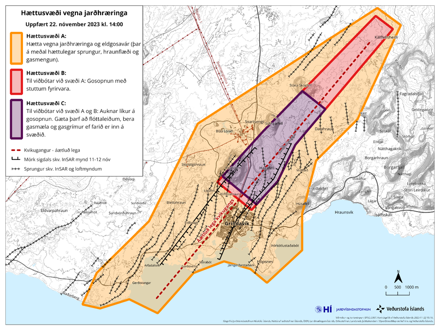
Hættusvæði vegna jarðhræringa, Uppfært 22. nóvember 2023 kl. 14:00
(Danger zone due to earthquakes, Updated November 22, 2023 at 14:00)
Icelandic Meteorological Office (IMO). (2023). Hættusvæði vegna jarðhræringa, 20. nóvember 2023.
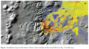
Figure in a journal article
Inundation map for the Grave Noire event overlain on the local GIS
Figure 6 in: Latutrie, B., Andredakis, I., De Groeve, T., Harris, A. J. L., Langlois, E., de Vries, B. V. W., Saubin, E., Bilotta, G., Cappello, A., Crisci, G.M., D'ambrosio, D., Del Negro, C., Favalli, M., Fujita, E., Iovine, G., Kelfoun, K., Rongo, R., Spataro, W., Tarquini, S., Coppola, D., Ganci, G., Marchese, F., Pergola, N., & Tramutoli, V. (2016). Testing a geographical information system for damage and evacuation assessment during an effusive volcanic crisis. In: Harris, A.J.L., De Groeve, T., & Carn, S.A. (Eds.) Detecting, Modelling and Responding to Effusive Eruptions. Geological Society, London, Special Publications, 426(1), p. 649-672. https://doi.org/10.1144/SP426.19
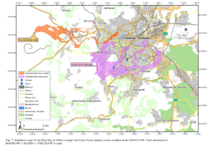
Figure in a journal article
Inundation map for the Petit Puy de Dome (orange) and Grave Noire (purple) events overlain on the GDACS GIS
Figure 7 in: Latutrie, B., Andredakis, I., De Groeve, T., Harris, A. J. L., Langlois, E., de Vries, B. V. W., Saubin, E., Bilotta, G., Cappello, A., Crisci, G.M., D'ambrosio, D., Del Negro, C., Favalli, M., Fujita, E., Iovine, G., Kelfoun, K., Rongo, R., Spataro, W., Tarquini, S., Coppola, D., Ganci, G., Marchese, F., Pergola, N., & Tramutoli, V. (2016). Testing a geographical information system for damage and evacuation assessment during an effusive volcanic crisis. In: Harris, A.J.L., De Groeve, T., & Carn, S.A. (Eds.) Detecting, Modelling and Responding to Effusive Eruptions. Geological Society, London, Special Publications, 426(1), p. 649-672. https://doi.org/10.1144/SP426.19
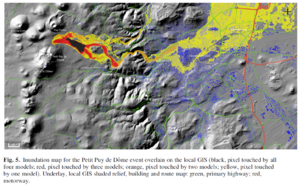
Figure in a journal article
Inundation map for the Petit Puy de Dome event overlain on the local GIS
Figure 5 in: Latutrie, B., Andredakis, I., De Groeve, T., Harris, A. J. L., Langlois, E., de Vries, B. V. W., Saubin, E., Bilotta, G., Cappello, A., Crisci, G.M., D'ambrosio, D., Del Negro, C., Favalli, M., Fujita, E., Iovine, G., Kelfoun, K., Rongo, R., Spataro, W., Tarquini, S., Coppola, D., Ganci, G., Marchese, F., Pergola, N., & Tramutoli, V. (2016). Testing a geographical information system for damage and evacuation assessment during an effusive volcanic crisis. In: Harris, A.J.L., De Groeve, T., & Carn, S.A. (Eds.) Detecting, Modelling and Responding to Effusive Eruptions. Geological Society, London, Special Publications, 426(1), p. 649-672. https://doi.org/10.1144/SP426.19
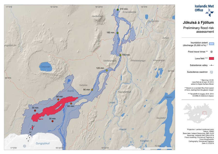
Official, Map in an information statement
Jökulsá á Fjöllum Preliminary Flood Risk Assessment
(Jökulsá á Fjöllum Preliminary Flood Risk Assessment)
Iceland Meteorological Office (IMO). (2014). Jökulsá á Fjöllum Preliminary Flood Risk Assessment.