
Advanced Search for Maps
Showing 1381-1390 of 2217
Unknown format
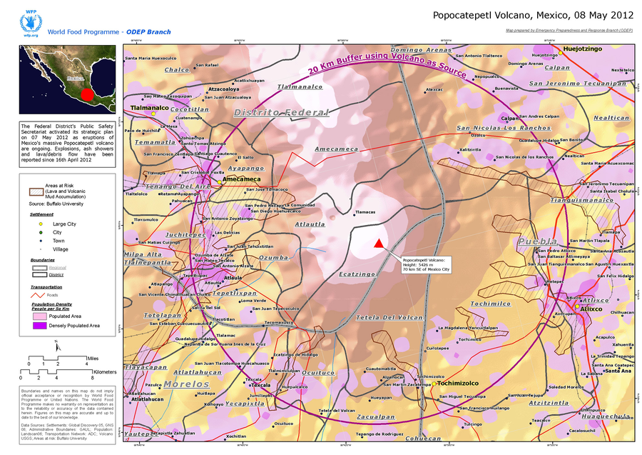
Popocatepetl Volcano, Mexico, 08 May 2012
World Food Programme. (2012). Popocatepetl Volcano, Mexico, 08 May 2012. World Food Programme, Emergency Preparedness and Response Branch (ODEP)
Official, Figure in hazard assessment
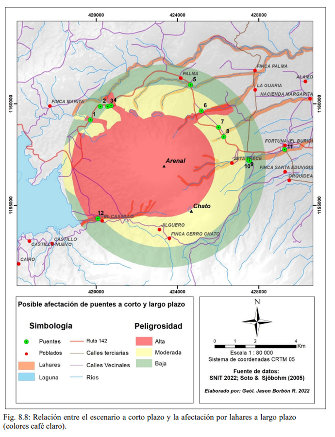
Posible afectación de puentes a corto y largo plazo
(Possible impact on bridges in the short and long term)
Figure 8.8 in: Alvarado, G.E., Brenes-André, F., Núñez, D., Borbón, J., Ramírez, M.A., Alpízar, Y., Núñez, S., Sibaja, J.P., Esquivel, L. (2023). Actualización del Análisis del Peligro Volcánico del Arenal, Costa Rica. Instituto Costarricense de Electricidad (ICE). Mayo 2023.
Official, Figure in hazard assessment
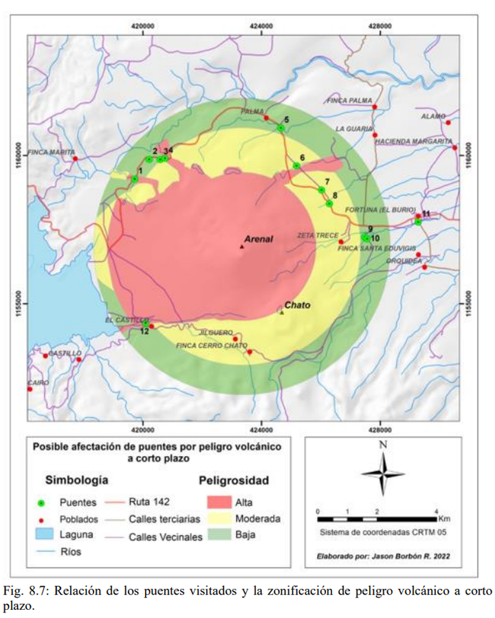
Posible afectación de puentes por peligro volcánico a corto plazo
(Possible impact on bridges due to short-term volcanic danger)
Figure 8.7 in: Alvarado, G.E., Brenes-André, F., Núñez, D., Borbón, J., Ramírez, M.A., Alpízar, Y., Núñez, S., Sibaja, J.P., Esquivel, L. (2023). Actualización del Análisis del Peligro Volcánico del Arenal, Costa Rica. Instituto Costarricense de Electricidad (ICE). Mayo 2023.
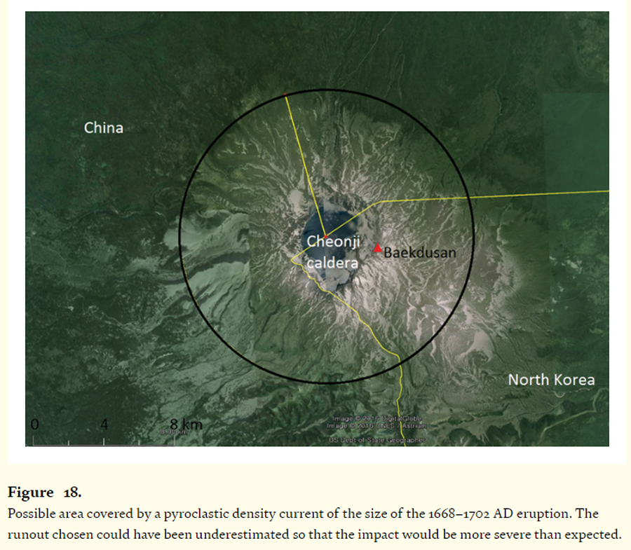
Figure in a journal article
Possible area covered by a pyroclastic density current of the size of the 1668–1702 AD eruption.
Figure 18 in: Paone, A., & Yun, S. H. (2016). Pyroclastic density current hazards at the Baekdusan volcano, Korea: analyses of several scenarios from a small-case to the worst-case colossal eruption. In: Németh, K. (Ed.) Updates in Volcanology-From Volcano Modelling to Volcano Geology. IntechOpen. https://doi.org/10.5772/62340
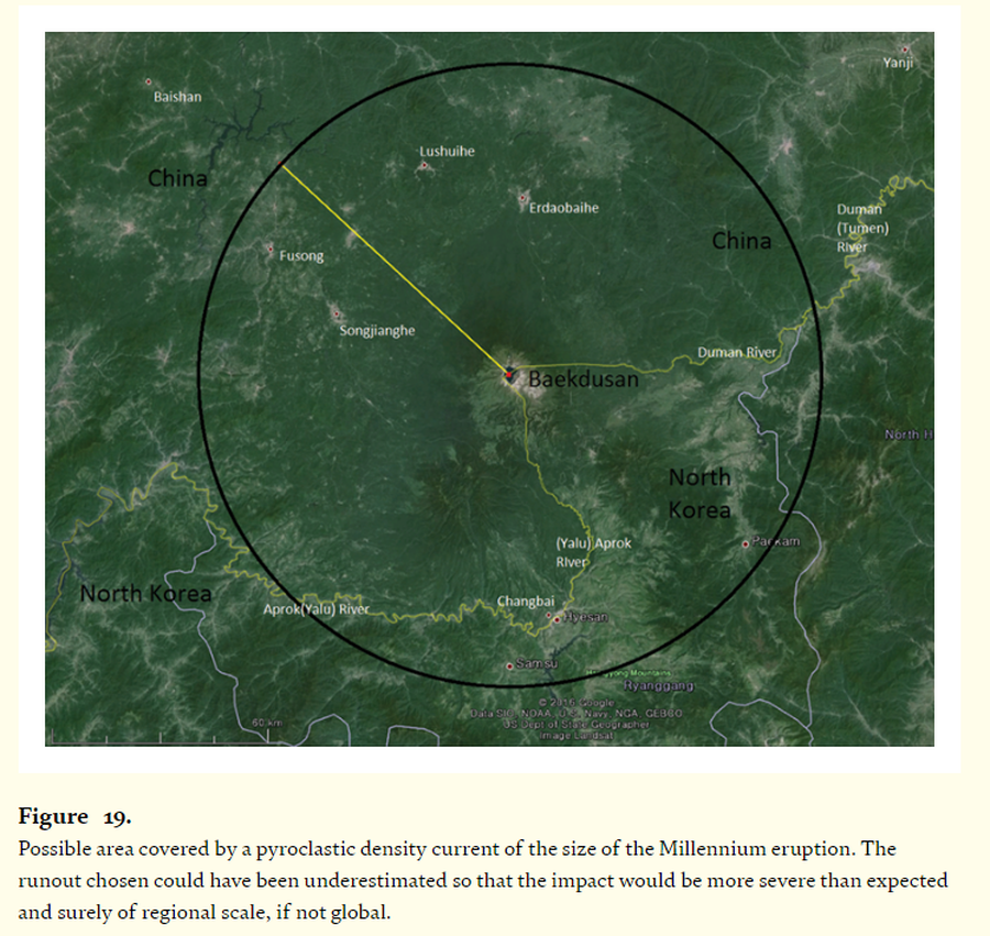
Figure in a journal article
Possible area covered by a pyroclastic density current of the size of the Millennium eruption
Figure 19 in: Paone, A., & Yun, S. H. (2016). Pyroclastic density current hazards at the Baekdusan volcano, Korea: analyses of several scenarios from a small-case to the worst-case colossal eruption. In: Németh, K. (Ed.) Updates in Volcanology-From Volcano Modelling to Volcano Geology. IntechOpen. https://doi.org/10.5772/62340
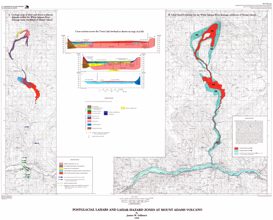
Official, Insert/poster-size map with accompanying report
Postglacial Lahars and Lahar-Hazard Zones at Mount Adams Volcano
Plate 2 in: Vallance, J.W. (1999). Postglacial lahars and potential hazards in the White Salmon River system on the southwest flank of Mount Adams, Washington. U.S. Geological Survey, Bulletin 2161, 49 p., 2 plates. https://doi.org/10.3133/b2161
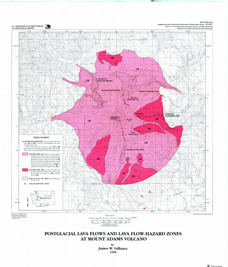
Official, Insert/poster-size map with accompanying report
Postglacial Lava Flows and Lava Flow-Hazard Zones at Mount Adams Volcano
Plate 1 in: Vallance, J.W. (1999). Postglacial lahars and potential hazards in the White Salmon River system on the southwest flank of Mount Adams, Washington. U.S. Geological Survey, Bulletin 2161, 49 p., 2 plates. https://doi.org/10.3133/b2161
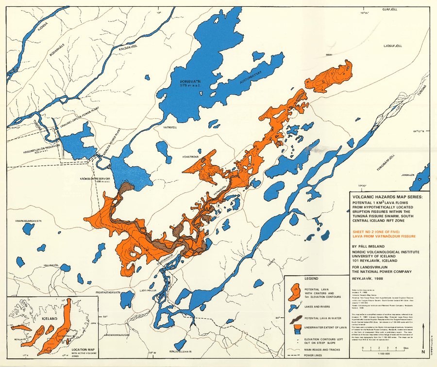
Official, Map sheet or poster
Potential 1 km³ Lava Flows From Hypothetically Located Eruption Fissures Within The Tungná Fissure Swarm, South Central Iceland Rift Zone
Sheet 2 in: Imsland, P. (1988). Volcanic Hazard Map Series. Potential 1 km³ lava flows from hypothetically located eruption fissures within the Tungná Fissure Swarm, South Central Iceland Rift Zone (five sheets). 1:100,000. Nordic Volcanological Institute and National Power Company, Reykjavik. (Simplified from: Imsland. P., 1987. Volcanic Hazards Map: Potential Lawa Flows from hypothetically located Eruption Fissures within the Tungná Fissure Swarm. South Central Iceland Rift Zone. (six sheets in a 1:50,000 scale with 5 m contour interval).
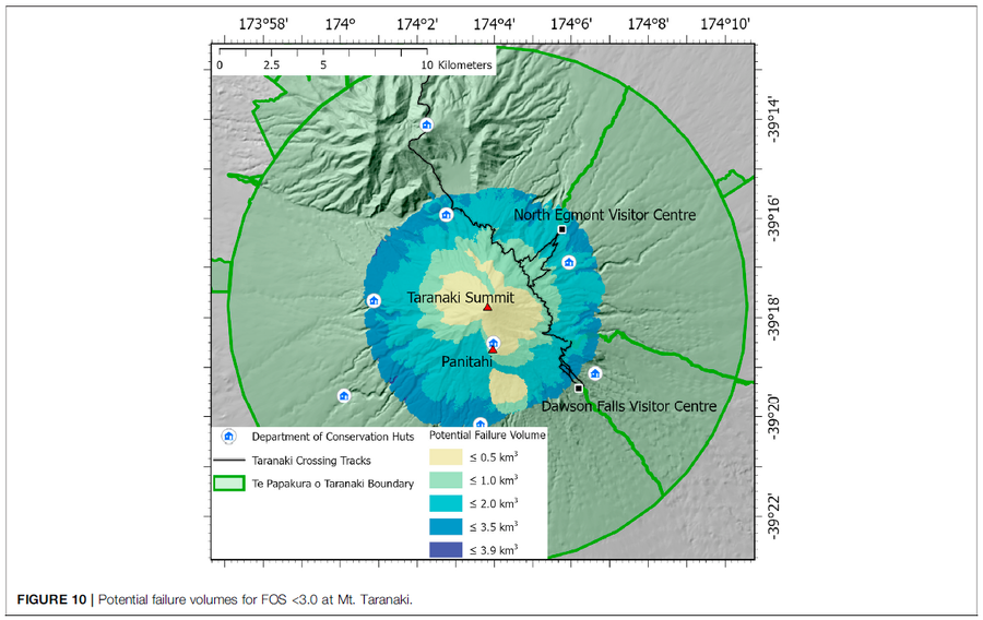
Figure in a journal article
Potential failure volumes for FOS <3.0 at Mt. Taranaki
Figure 10 in: Mead, S., Procter, J., Bebbington, M., & Rodriguez-Gomez, C. (2022). Probabilistic Volcanic Hazard Assessment for National Park Infrastructure Proximal to Taranaki Volcano (New Zealand). Frontiers in Earth Science, 435. https://doi.org/10.3389/feart.2022.832531
Official, Figure in hazard assessment
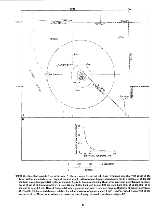
Potential hazards from airfall ash
Figure 3 in: Miller, C.D., Mullineaux, D.R., Crandell, D.R. & Bailey, R.A. (1982). Potential hazards from future volcanic eruptions in the Long Valley-Mono Lake area, east-central California and southwest Nevada; a preliminary assessment. U.S. Geological Survey, Circular 877, 10 p. https://doi.org/10.3133/cir877