
Advanced Search for Maps
Showing 1391-1400 of 2217
Official, Unknown format
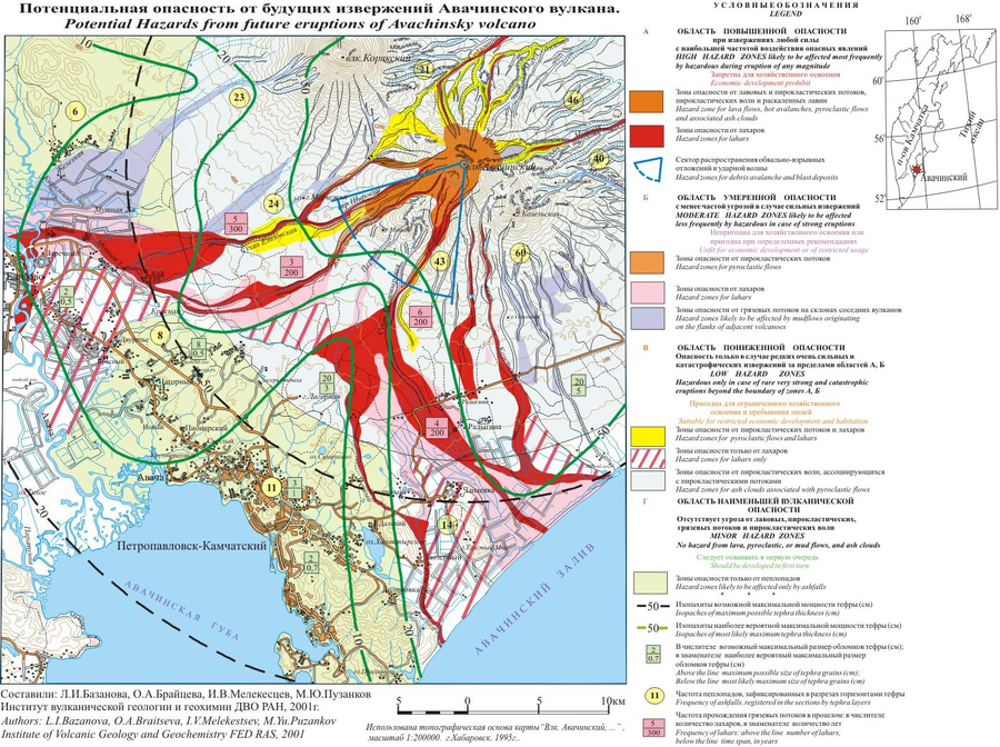
Potential Hazards from future eruptions of Avachinsky volcano
Bazanova, L.I., Braitseva, O.A., Melekestsev, I.V., & Puzankov, M.Yu. (2001). Potential Hazards from future eruptions of Avachinsky volcano. Institute of Volcanic Geology and Geochemistry FED RAS.

Official, Map sheet or poster
Potential Hazards From Future Eruptions of Mount Rainer, Washington.
Crandell, D.R. (1973). Map showing potential hazards from future eruptions of Mount Rainier, Washington. U.S. Geological Survey, I-Map 836. https://doi.org/10.3133/i836
Official, Insert/poster-size map with accompanying report
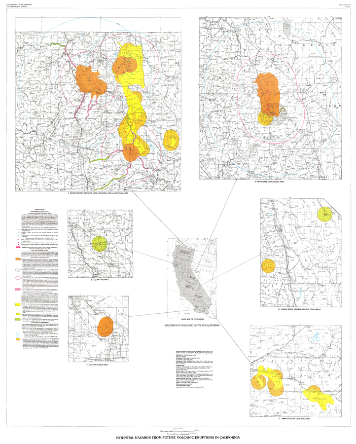
Potential Hazards from future volcanic eruptions in California
Plate 1 in: Miller, C.D. (1989). Potential hazards from future volcanic eruptions in California. U.S. Geological Survey, Bulletin 1847, 17 p., 2 tables, 1 plate, scale 1:500,000.
Official, Map sheet or poster
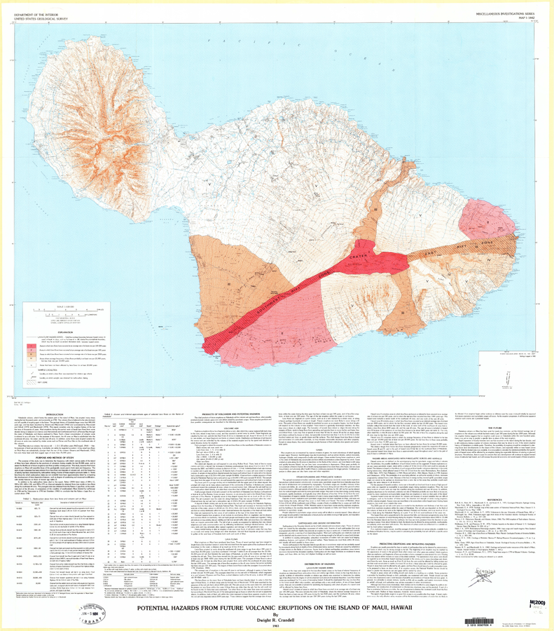
Potential Hazards from Future Volcanic Eruptions of the Island of Maui, Hawaii
Plate 1 in: Crandell, D.R. (1983). Potential hazards from future volcanic eruptions on the Island of Maui, Hawaii. U.S. Geological Survey, IMAP 1442. https://doi.org/10.3133/i1442
Official, Figure on website
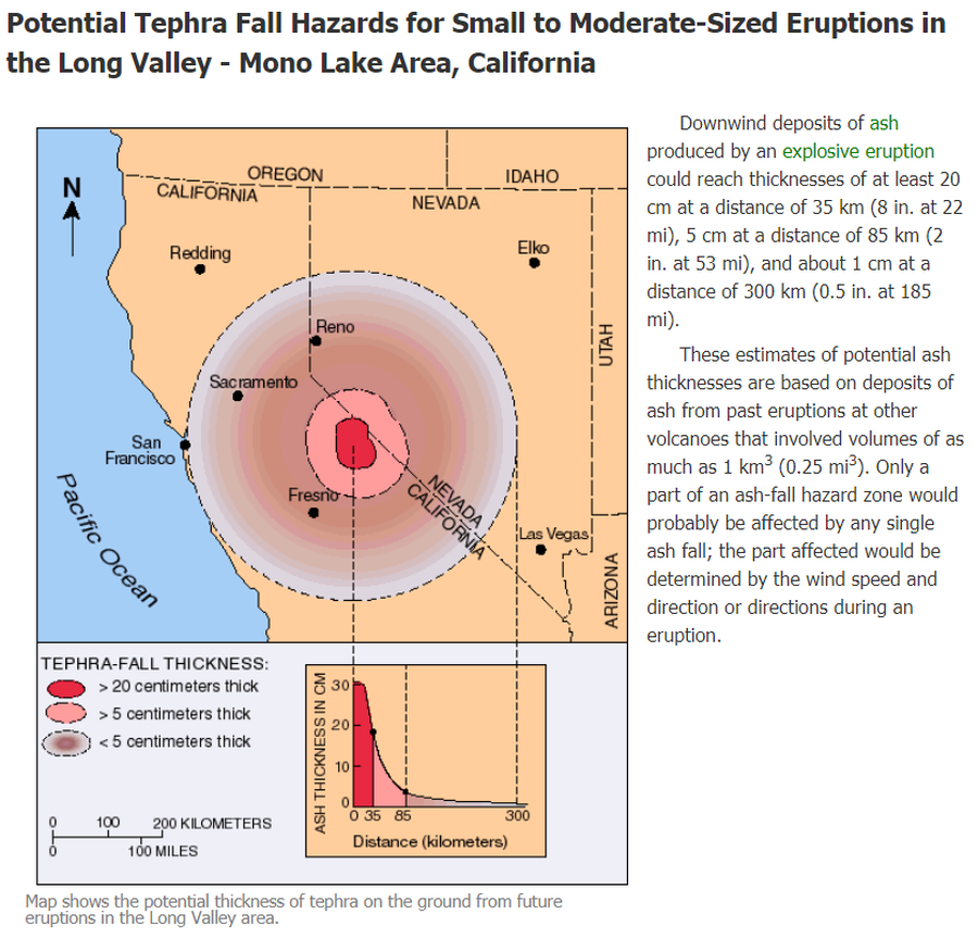
Potential Tephra Fall Hazards for Small to Moderate-Sized Eruptions in the Long Valley - Mono Lake Area, California
U.S. Geological Survey (USGS). (2012). Potential Tephra Fall Hazards for Small to Moderate-Sized Eruptions in the Long Valley - Mono Lake Area, California. U.S. Geological Survey. Long Valley Caldera, Volcano Hazards in the Long Valley - Mono Lake Area, California. https://www.usgs.gov/volcanoes/long-valley-caldera/volcano-hazards-long-valley-mono-lake-area-california
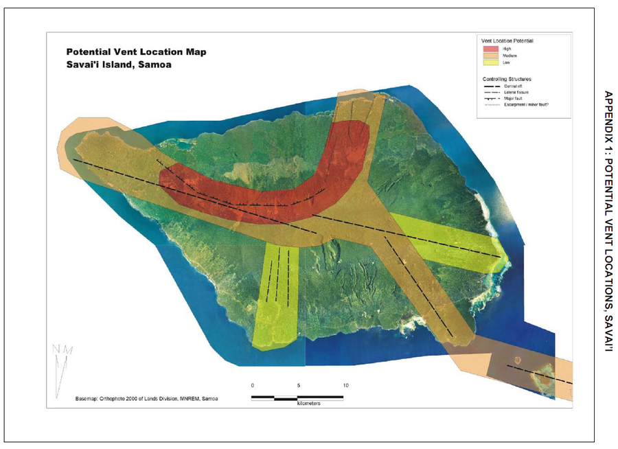
Official, Figure in hazard assessment
Potential Vent Locations Map, Savai'i Island, Samoa
Appendix 1 in: Cronin, S., Bonte-Grapentin, M. & Nemeth, K. (2006). Samoa technical report - Review of volcanic hazard maps for Savai'i and Upolu. Pacific Islands Applied Geoscience Commission (SOPAC) Project Report 59.
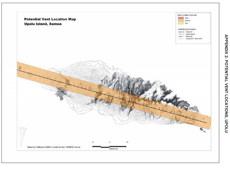
Official, Figure in hazard assessment
Potential Vent Locations Map, Upolu Island, Samoa
Appendix 2 in: Cronin, S., Bonte-Grapentin, M. & Nemeth, K. (2006). Samoa technical report - Review of volcanic hazard maps for Savai'i and Upolu. Pacific Islands Applied Geoscience Commission (SOPAC) Project Report 59.

Official, Insert/poster-size map with accompanying report
Potential Volcanic Hazards from Future Activity of Mount Baker, Washington
Plate 1 in: Gardner, C.A., Scott, K.M., Miller, C.D., Myers, B., Hildreth, W., & Pringle, P.T. (1995). Potential volcanic hazards from future activity of Mount Baker, Washington. U.S. Geological Survey, Open-File Report 95-498, 16 p., 1 plate, scale 1:100,000. https://doi.org/10.3133/ofr95498
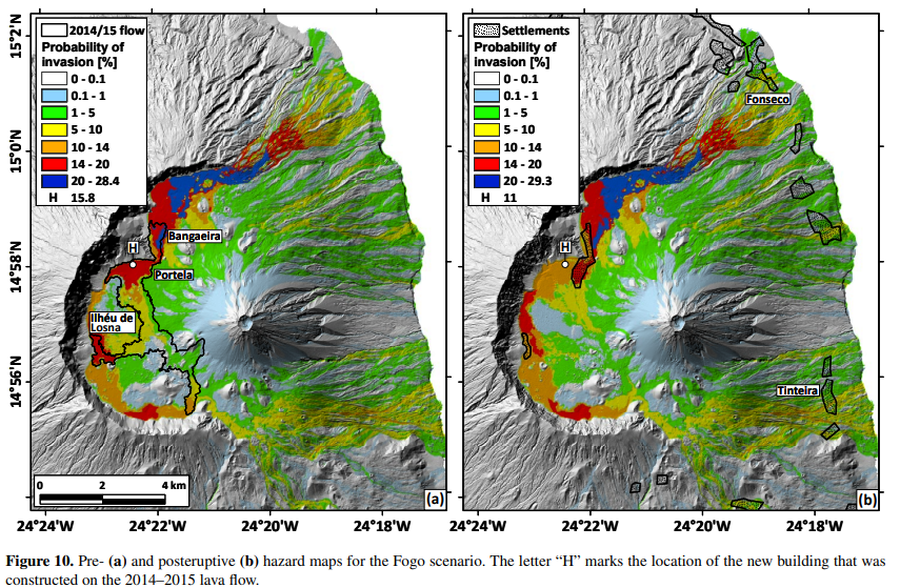
Figure in a journal article
Pre- and posteruptive hazard maps for the Fogo scenario
Figure 10 in: Richter, N., Favalli, M., de Zeeuw-van Dalfsen, E., Fornaciai, A., da Silva Fernandes, R. M., Pérez, N. M., Levy, J., Victoria, S.S., & Walter, T. R. (2016). Lava flow hazard at Fogo Volcano, Cabo Verde, before and after the 2014–2015 eruption. Natural Hazards and Earth System Sciences, 16(8), 1925-1951. https://doi.org/10.5194/nhess-16-1925-2016
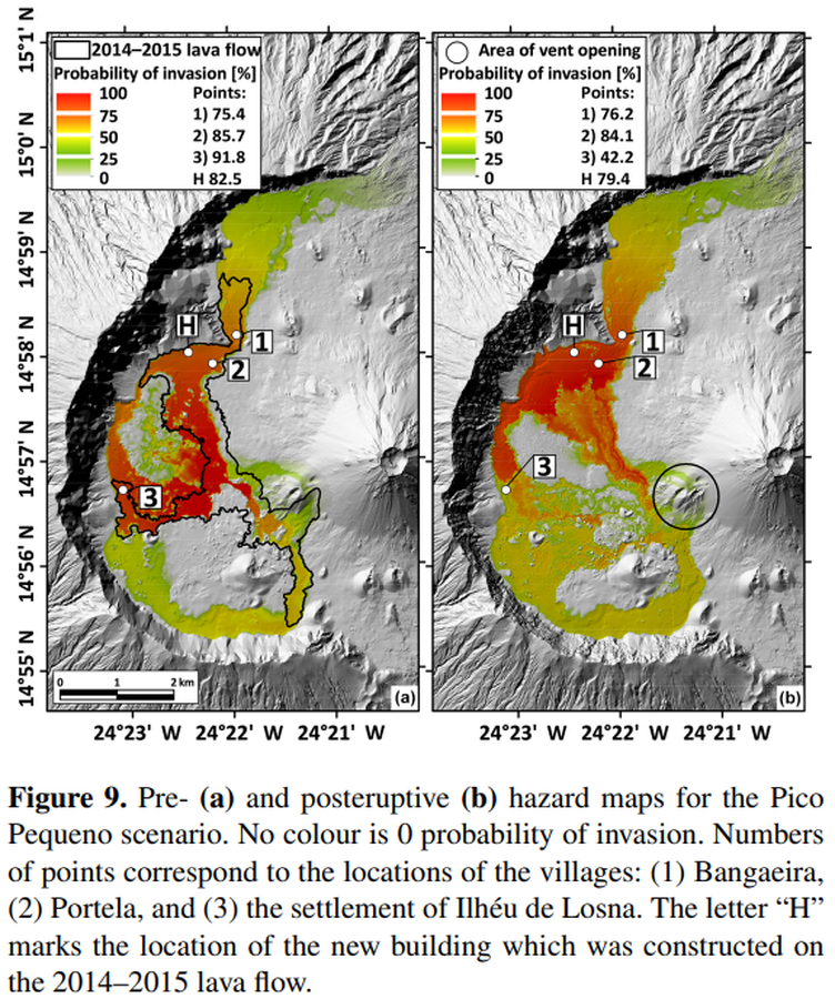
Figure in a journal article
Pre- and posteruptive hazard maps for the Pico Pequeno scenario
Figure 9 in: Richter, N., Favalli, M., de Zeeuw-van Dalfsen, E., Fornaciai, A., da Silva Fernandes, R. M., Pérez, N. M., Levy, J., Victoria, S.S., & Walter, T. R. (2016). Lava flow hazard at Fogo Volcano, Cabo Verde, before and after the 2014–2015 eruption. Natural Hazards and Earth System Sciences, 16(8), 1925-1951. https://doi.org/10.5194/nhess-16-1925-2016