
Advanced Search for Maps
Showing 1-10 of 139
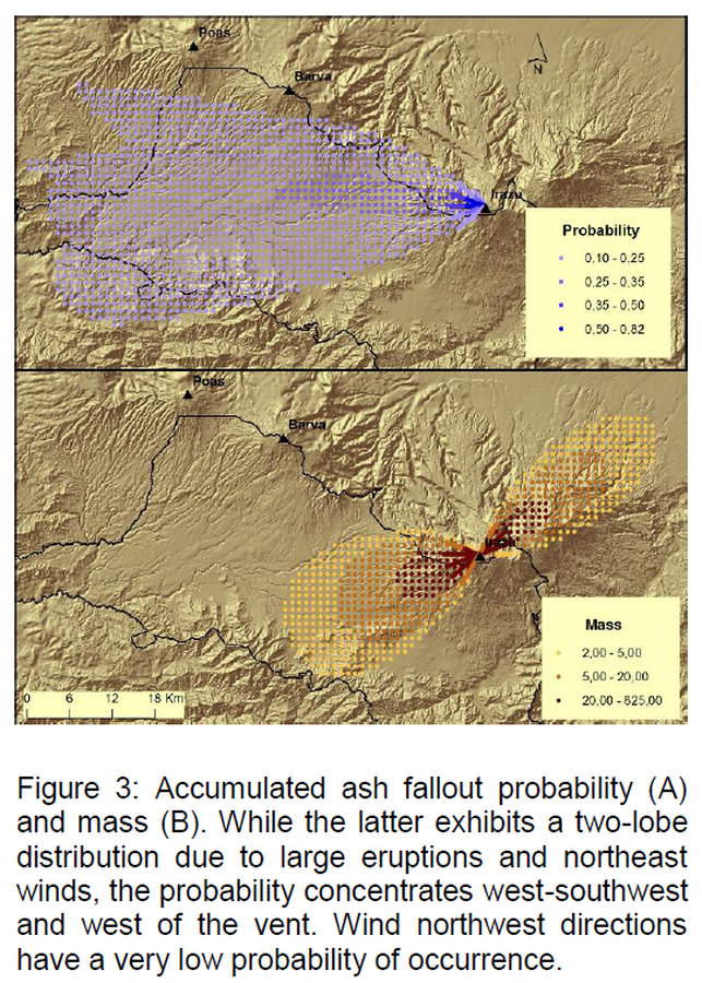
Figure in a journal article
Accumulated ash fallout probability and mass
Figure 3 in: Barrantes, G., Núñez, S., & Malavassi, E. (2018). Ash fallout hazard from Irazú volcano, Costa Rica. Revista Geográfica de Chile Terra Australis, 54(1), 13-25. https://doi.org/10.23854/07199562.2018541Barrantes13
Official (foreign agency), Insert/poster-size map with accompanying report
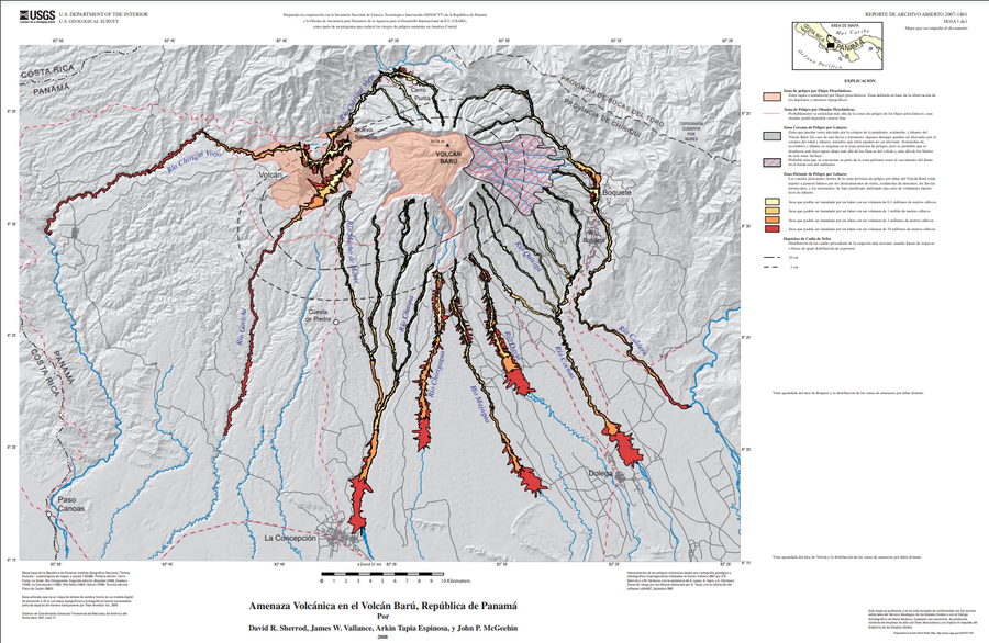
Amenaza Volcánica en el Volcán Barú, República de Panamá
(Volcano Hazards of Volcán Barú, Republic of Panamá)
Plate 1 (Spanish) in: Sherrod, D. R., Vallance, J. W., Espinosa, A. T., & McGeehin, J. P. (2007). Volcan Baru—eruptive history and volcano-hazards assessment. U.S. Geological Survey, Open-File Report, 2007-1401.
Official, Map in an information statement
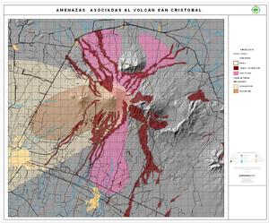
Amenazas Asociadas al Volcán San Cristóbal
(Hazards Associated with the San Cristobal Volcano)
Instituto Nicaragüense de Estudios Territoriales (INETER). (2006). Amenazas Asociadas al Volcán San Cristóbal. https://webserver2.ineter.gob.ni/vol/cristobal/Chinandega.gif

Official, Flyer, brochure, short fact-sheet, or handout
Are You at Risk from the Next Eruption of Mount Hood? Hazards Zonation Map
Gardner, C. A., Scott, W. E., Major, J. J., & Pierson, T. C. (2000). Mount Hood-history and hazards of Oregon's most recently active volcano. US Geological Survey, Fact Sheet 060-00 (PDF Version). https://doi.org/10.3133/fs06000
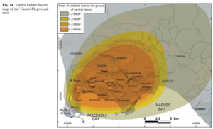
Figure in a journal article
Areas of probable load on the ground of particle fallout
Figure 14 in: Orsi, G., Di Vito, M. A., & Isaia, R. (2004). Volcanic hazard assessment at the restless Campi Flegrei caldera. Bulletin of Volcanology, 66(6), p. 514-530. https://doi.org/10.1007/s00445-003-0336-4

Figure in a journal article
Ash fallout simulations (thickness) with a 5-km column height and volume of 0.3 km³
Figure 10 in: Bartolini, S., Geyer, A., Martí, J., Pedrazzi, D., & Aguirre-Díaz, G. (2014). Volcanic hazard on Deception Island (South Shetland Islands, Antarctica). Journal of Volcanology and Geothermal Research, 285, p. 150-168. https://doi.org/10.1016/j.jvolgeores.2014.08.009
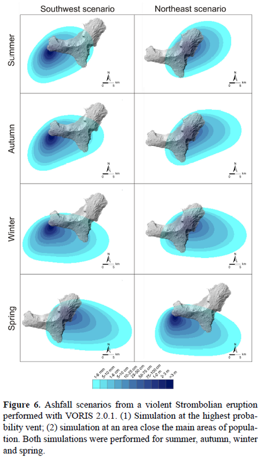
Figure in a journal article
Ashfall scenarios from a violent Strombolian eruption performed with VORIS 2.0.1.
Figure 6 in: Becerril, L., Bartolini, S., Sobradelo, R., Martí, J., Morales, J. M., & Galindo, I. (2014). Long-term volcanic hazard assessment on El Hierro (Canary Islands). Natural Hazards and Earth System Sciences, 14(7), 1853-1870. https://doi.org/10.5194/nhess-14-1853-2014, 2014
Official, Map sheet or poster
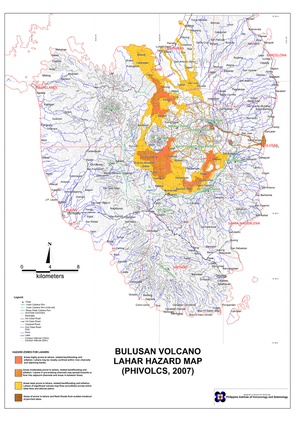
Bulusan Volcano Lahar Hazard Map
Philippine Institute of Volcanology and Seismology (PHIVOLCS). (2007). Bulusan Volcano Lahar Hazard Map.

Official, Figure in hazard assessment
Cálculo por medio del ASH3D de la caída de ceniza de una columna eruptiva de 3 km de altura sobre el cráter del Rincón de la Vieja, según los vientos presentes en el área el 14 mayo 2022
(Calculation using ASH3D of the ash fall from a 3 km high eruptive column above the Rincón de la Vieja crater, according to the winds present in the area on May 14, 2022)
Figure 2.3 in: Alvarado, G.E., Brenes-André, J., Venegas, L., Alpízar, Y., Núñez, S., Sánchez, M., Abarca, K., Abarca, J., Báez, W.A., Sibaja, J.P., Esquivel, L., & Arcia, T. (2022). Análisis del Peligro Volcánico del Rincón de la Vieja, Costa Rica. Instituto Costarricense de Electricidad (ICE). Setiembre 2022.
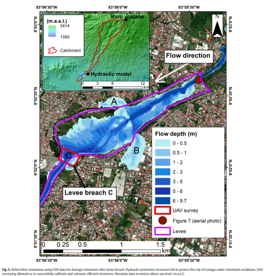
Figure in a journal article
Debris flow simulation using UAV data for damage estimation after levee breach
Figure 5 in: Granados-Bolaños, S., Quesada-Román, A., & Alvarado, G. E. (2021). Low-cost UAV applications in dynamic tropical volcanic landforms. Journal of Volcanology and Geothermal Research, 410, 107143.