
Advanced Search for Maps
Showing 1-10 of 75
Official, Figure in hazard assessment
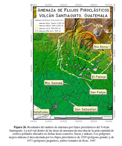
Amenaza de Flujos Piroclásticos Volcán Santiaguito, Guatemala
(Threat of Pyroclastic Flows Santiaguito Volcano, Guatemala)
Figure 26 in: UNESCO, Instituto Nacional de Sismología, Vulcanología, Meteorología e Hidrología (INSIVUMEH), Coordinadora Nacional para la Reducción de Desastres (CONRED), Instituto Geográfico Nacional (IGN), Facultad de Agronomía (FAUSAC), Universidad de San Carlos de Guatemala Centro de Estudios Superiores de Energía y Minas (CESEM), Universidad de San Carlos de Guatemala, Escuela Regional de Ingeniería Sanitaria (ERIS). (2003). Zonificación de Amenazas Naturales en la cuenca del río Samalá y Análisis de vulnerabilidad y riesgo en la población de San Sebastián Retalhuleu, Guatemala, Centro América. Capacity Building for Natural Disaster Reduction (CBNDR) Regional Action Program for Central America (RAPCA). Guatemala, Septiembre 2003.
Santiaguito (Santa María), Guatemala
Figure in a journal article
Amenaza de Flujos Piroclásticos Volcán Santiaguito, Guatemala
(Threat of Pyroclastic Flows Santiaguito Volcano, Guatemala)
Figure 4 in: Barillas-Cruz, M., van Westen, C., Orozco, E., Thonon, I., Lira, E., Guarín, G. P., & Tax, P. (2003). Zonificación de amenazas naturales en la cuenca del Río Samalá y análisis de vulnerabilidad y riesgo en la población de San Sebastián Retalhuleu, Guatemala. Retalhuleu, Guatemala: GEOS, 23(1), p. 17-24.
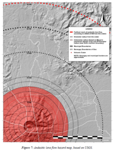
Figure in a thesis or dissertation
Andesitic lava flow hazard map
Figure 7 in: Daita, T.J.E. (2020). Preliminary Volcanic Hazard Assessment of Goa, Camarines Sur, Philippines. Thesis, Partido State University, Goa, Camarines Sur, Philippines.
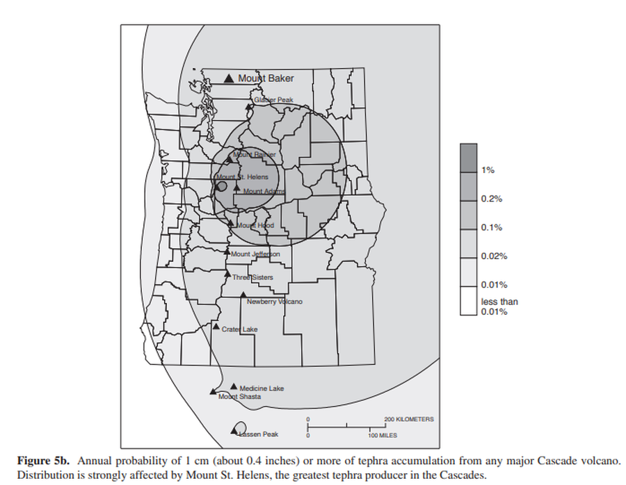
Official, Figure in hazard assessment
Annual probability of 1 cm (about 0.4 inches) or more of tephra accumulation from any major Cascade volcano
Figure 5b in: Gardner, C.A., Scott, K.M., Miller, C.D., Myers, B., Hildreth, W., & Pringle, P.T. (1995). Potential volcanic hazards from future activity of Mount Baker, Washington. U.S. Geological Survey, Open-File Report 95-498, 16 p., 1 plate, scale 1:100,000. https://doi.org/10.3133/ofr95498
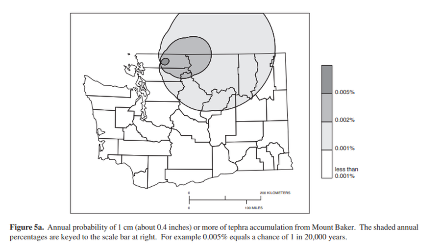
Official, Figure in hazard assessment
Annual probability of 1 cm (about 0.4 inches) or more of tephra from Mount Baker.
Figure 5a in: Gardner, C.A., Scott, K.M., Miller, C.D., Myers, B., Hildreth, W., & Pringle, P.T. (1995). Potential volcanic hazards from future activity of Mount Baker, Washington. U.S. Geological Survey, Open-File Report 95-498, 16 p., 1 plate, scale 1:100,000. https://doi.org/10.3133/ofr95498
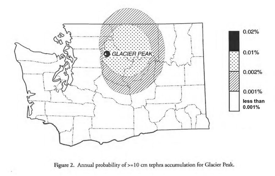
Official, Figure in hazard assessment
Annual probability of >=10 cm tephra accumulation for Glacier Peak
Figure 2 in: Waitt, R.B., Mastin, L.G., & Begét, J.E. (1995). Volcanic-Hazard Zonation for Glacier Peak Volcano, Washington. U.S. Geological Survey, Open-File Report 95-499, 9 p., 1 plate. https://doi.org/10.3133/ofr95499
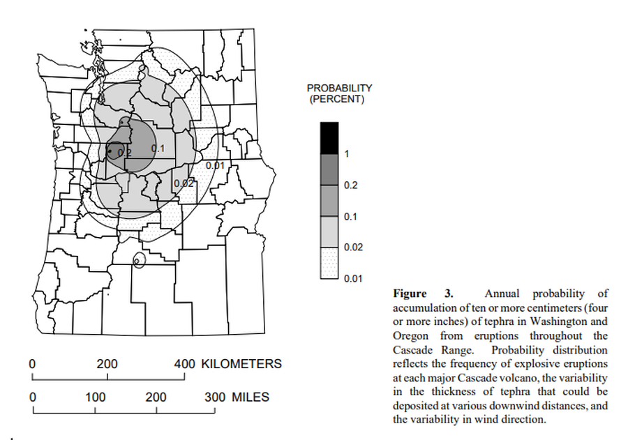
Official, Figure in hazard assessment
Annual probability of accumulation of ten or more centimeters (four or more inches) of tephra in Washington and Oregon from eruptions throughout the Cascade Range.
Figure 3 in: Wolfe, E.W. & Pierson, T.C. (1995). Volcanic-Hazard Zonation for Mount St. Helens, Washington, 1995. U.S. Geological Survey, Open-File Report 95-497, 12 p., 1 plate. https://doi.org/10.3133/ofr95497
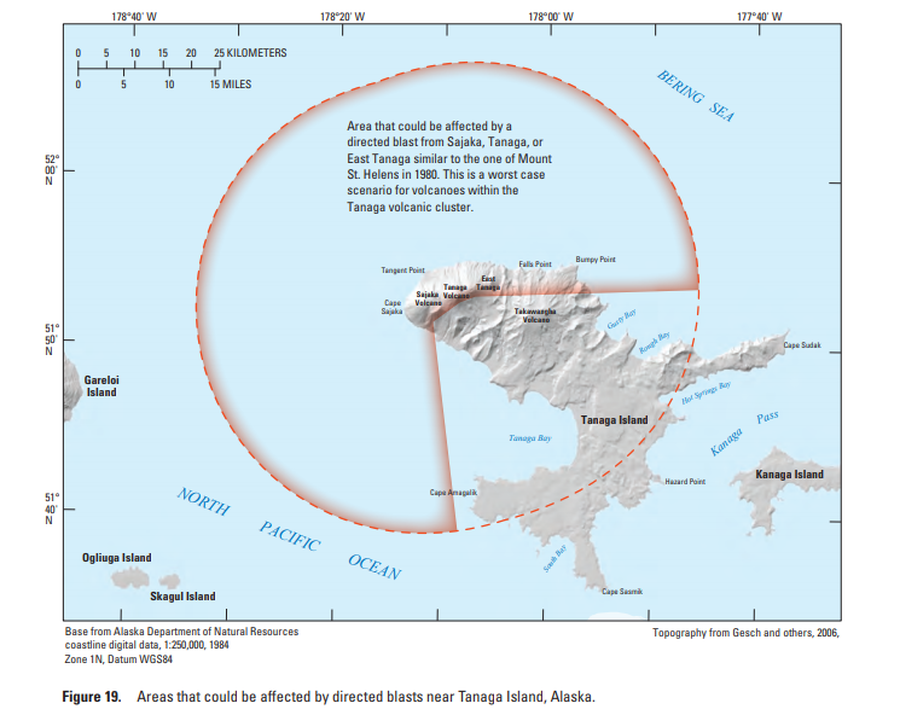
Official, Figure in hazard assessment
Areas that could be affected by directed blasts near Tanaga Island, Alaska
Figure 19 in: Coombs, M.L., McGimsey, R.G. & Browne, B.L. (2007). Preliminary volcano-hazard assessment for the Tanaga volcanic cluster, Tanaga Island, Alaska. U.S. Geological Survey, Scientific Investigations Report 2007-5094, 41 p., 1 plate. https://doi.org/10.3133/sir20075094
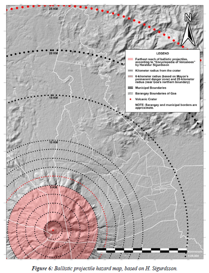
Figure in a thesis or dissertation
Ballistic projectile hazard map
Figure 6 in: Daita, T.J.E. (2020). Preliminary Volcanic Hazard Assessment of Goa, Camarines Sur, Philippines. Thesis, Partido State University, Goa, Camarines Sur, Philippines.
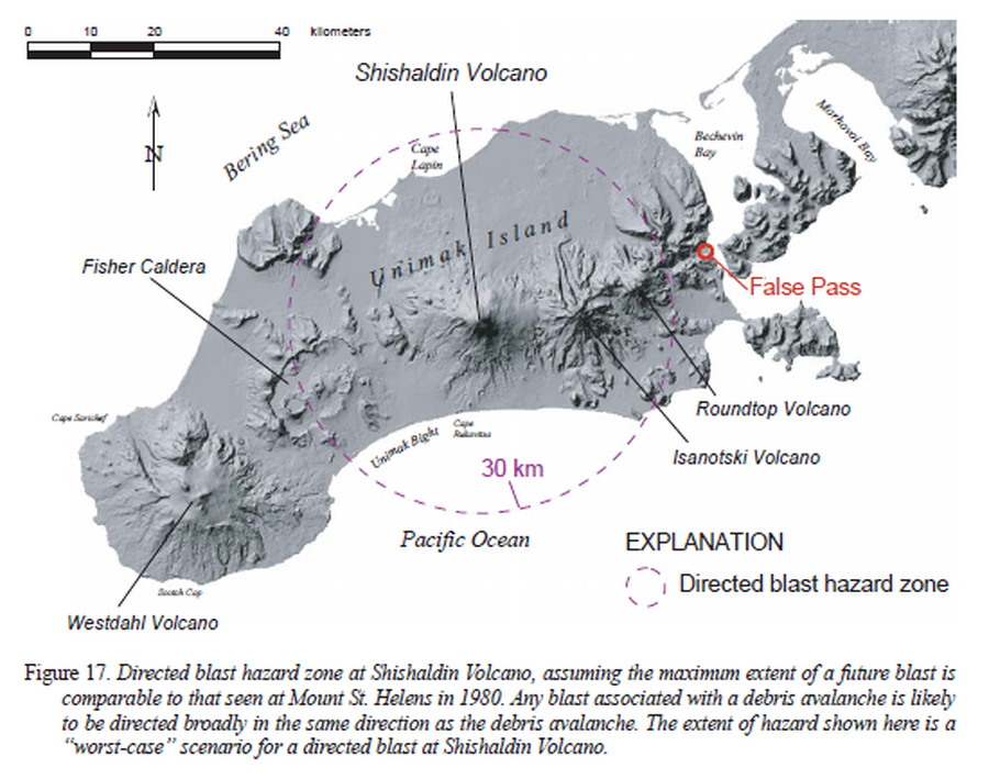
Official, Figure in hazard assessment
Directed blast hazard zone at Shishaldin Volcano
Figure 17 in: Beget, J.E., Nye, C.J., Schaefer, J.R. & Stelling, P.L. (2003). Preliminary volcano-hazard assessment for Shishaldin Volcano, Alaska. Alaska Division of Geological & Geophysical Surveys, Report of Investigations 2002-4, 28 p., 1 sheet, scale 1:500,000. http://doi.org/10.14509/2872