
Advanced Search for Maps
Showing 701-710 of 2217
Official, Figure in a journal article
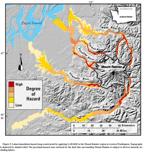
Lahar-inundation hazard map constructed by applying LAHARZ to the Mount Rainier region in western Washington
Figure 9 in: Iverson, R. M., Schilling, S. P., & Vallance, J. W. (1998). Objective delineation of lahar-inundation hazard zones. Geological Society of America Bulletin, 110(8), 972-984. https://doi.org/10.1130/0016-7606(1998)110<0972:ODOLIH>2.3.CO;2
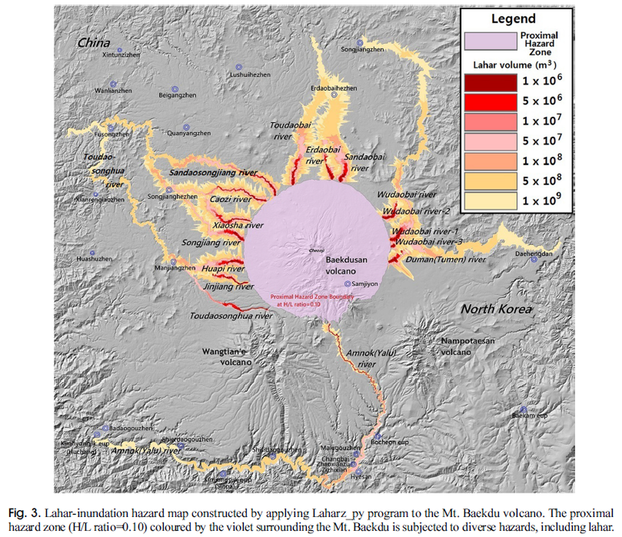
Figure in a journal article
Lahar-inundation hazard map constructed by applying Laharz_py program to the Mt. Baekdu volcano
Figure 3 in: Yun, S. H. & Chang, C. (2017). Prediction of Lahar Flow Inundation Areas Using LAHARZ_py Program: Application for the Mt. Baekdu Volcano. Economic and Environmental Geology, 50(4), 277-286. https://doi.org/10.9719/EEG.2017.50.4.277
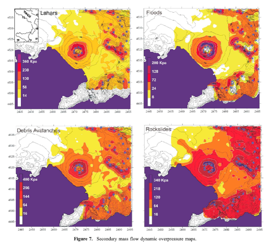
Figure in a journal article
Lahars, Floods, Debris Avalanches, Rockslides
Figure 7 in: Mastrolorenzo, G., & Pappalardo, L. (2010). Hazard assessment of explosive volcanism at Somma‐Vesuvius. Journal of Geophysical Research: Solid Earth, 115(B12). https://doi.org/10.1029/2009JB006871
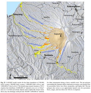
Figure in a journal article
LAHARZ model results for the lahar inundation of 100,000 (dark orange), 300,000 (light orange), 1,000,000 (light yellow), and 3,000,000 m³ (dark yellow)
Figure 22 in: Kushendratno, Pallister, J.S., Kristianto, Bina, F.R., McCausland, W., Carn, S., Haerani, N., Griswold, J., & Keeler, R. (2012). Recent explosive eruptions and volcano hazards at Soputan volcano—a basalt stratovolcano in north Sulawesi, Indonesia. Bulletin of volcanology, 74(7), 1581-1609. https://doi.org/10.1007/s00445-012-0620-2
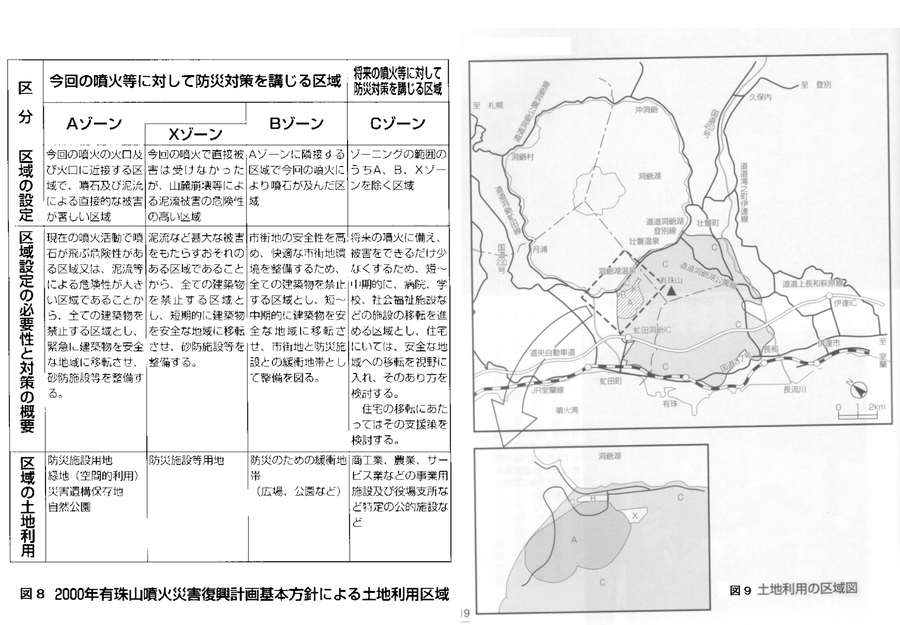
Official, Figure on website
Land use area map. Land use areas according to the basic policy of the 2000 Mt. Usu eruption disaster recovery plan.
Figure 8-9 in: Nakao, M. (2005). Eruption of Mt Usu, March 31 st 2000, at Mt Usu in Hokkaido. In: Failure Knowledge Database, 100 Selected Cases. http://www.shippai.org/fkd/en/cfen/CA1000619.html. Reprinted from: The Hokkaido Shimbun Press. (2002) 2000-Nen Usu-Zan Funka (The 2000 Mt. Usu Eruption). The Hokkaido Shimbun Press.
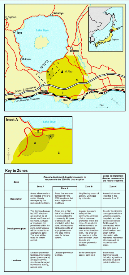
Figure in a journal article
Land use zoning map for areas around Mount Usu
Figure 3 in: Becker, J.S., Saunders, W.S.A., Robertson, C.M., Leonard, G.S., & Johnston, D.M. (2010). A synthesis of challenges and opportunities for reducing volcanic risk through land use planning in New Zealand. The Australasian Journal of Disaster and Trauma Studies, 2010-1. (Simplified from: Nakao 2005)
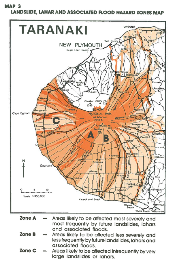
Official, Figure in hazard assessment
Landslide, Lahar and Associated Flood Hazard Zones Map
Map 3, Page 20 in: Neall, V.E. & Alloway, B.V. (1993). Volcanic hazards at Egmont volcano. Volcanic Hazards Working Group of the Scientific Advisory Committee, Ministry of Civil Defence. Volcanic Hazards Information Series, Number One, 2nd ed. 31 p.
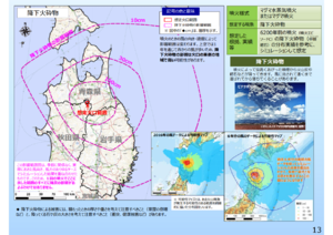
Official, Map in a booklet, long fact-sheet, or handbook
Large-scale eruption (assuming billions of cubic meters of magma eruption) pyroclastic fall
Page 13 in: Towada Volcanic Hazards Mitigation Committee. (2018). Towada Volcano Hazard Expected Impact Area Map. Omori Prefecture Disaster Risk Management Division, Akita Prefecture Disaster Prevention Division, Nagano City General Affairs Division, Kosaka Town General Affairs Division.
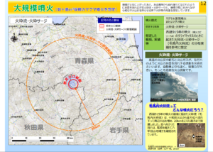
Official, Map in a booklet, long fact-sheet, or handbook
Large-scale eruption (assuming billions of cubic meters of magma eruption) pyroclastic flow/pyroclastic surge
Page 12 in: Towada Volcanic Hazards Mitigation Committee. (2018). Towada Volcano Hazard Expected Impact Area Map. Omori Prefecture Disaster Risk Management Division, Akita Prefecture Disaster Prevention Division, Nagano City General Affairs Division, Kosaka Town General Affairs Division.
Makushin, United States
Official, Figure in hazard assessment
Lateral blast hazard zone at Makushin Volcano, assuming the extent of a future blast is comparable to that at Mount St. Helens in 1980
Figure 13 in: Beget, J.E., Nye, C.J. & Bean, K.W. (2000). Preliminary volcano-hazard assessment for Makushin Volcano, Alaska. Alaska Division of Geological & Geophysical Surveys, Report of Investigation 2000-4, 22 p., 1 sheet, scale 1:100,000.
Official, Figure in hazard assessment
Lateral blast hazard zone at Makushin Volcano, assuming the extent of a future blast is comparable to that at Mount St. Helens in 1980
Figure 13 in: Beget, J.E., Nye, C.J. & Bean, K.W. (2000). Preliminary volcano-hazard assessment for Makushin Volcano, Alaska. Alaska Division of Geological & Geophysical Surveys, Report of Investigation 2000-4, 22 p., 1 sheet, scale 1:100,000.