
Advanced Search for Maps
Showing 761-770 of 2217
Official, Figure in a journal article
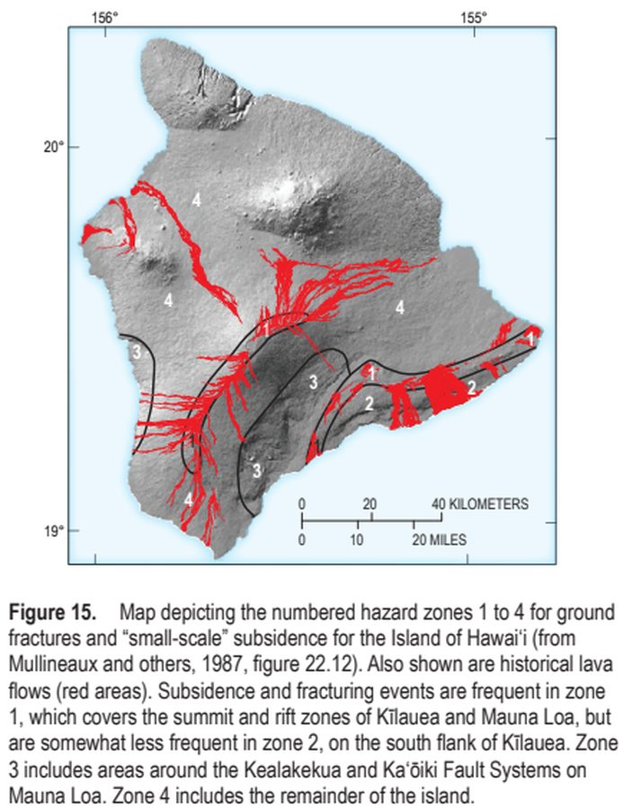
Map depicting the numbered hazard zones 1 to 4 for ground fractures and “small-scale” subsidence for the Island of Hawai‘i
Figure 15 in: Kauahikaua, J.P. & Tilling, R.I. (2014). Natural hazards and risk reduction in Hawai‘i. In: Poland, M.P., Takahashi, T.J., & Landowski, C.M. (eds.) Characteristics of Hawaiian Volcanoes. US Geological Survey Professional Paper 1801, p. 397-427. https://doi.org/10.3133/pp180110
Official, Figure in hazard assessment
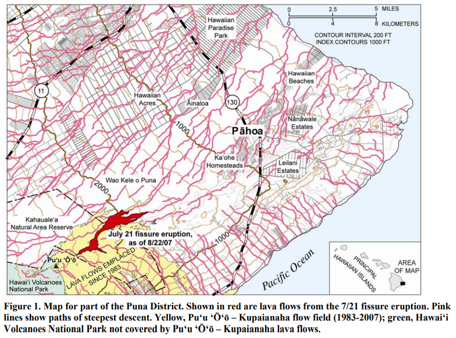
Map for part of the Puna District
Figure 1 in: Kauahikaua, J. (2007). Lava flow hazard assessment, as of August 2007, for Kīlauea east rift zone eruptions, Hawai‘i Island. U.S. Geological Survey Open-File Report 2007-1264, 9 p.

Official, Sign or billboard
Map of areas not recommended not to enter or camp - Ruapehu Volcanic Risk
Department of Conservation. (2020). Map of areas not recommended not to enter or camp - Ruapehu Volcanic Risk. September 2020 R183230.
Official, Figure in hazard assessment
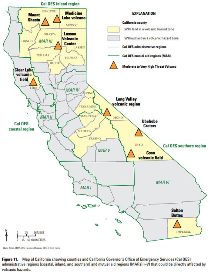
Map of California showing counties and California Governor’s Office of Emergency Services (Cal OES) administrative regions (coastal, inland, and southern) and mutual aid regions (MARs) I–VI that could be directly affected by volcanic hazards.
Figure 11 in: Mangan, M., Ball, J., Wood, N., Jones, J.L., Peters, J., Abdollahian, N., Dinitz, L., Blankenheim, S., Fenton, J., & Pridmore, C. (2019). California’s exposure to volcanic hazards. U.S. Geological Survey Scientific Investigations Report 2018–5159, v. 1.1, 49 p. https://doi.org/10.3133/sir20185159
Official, Figure in hazard assessment
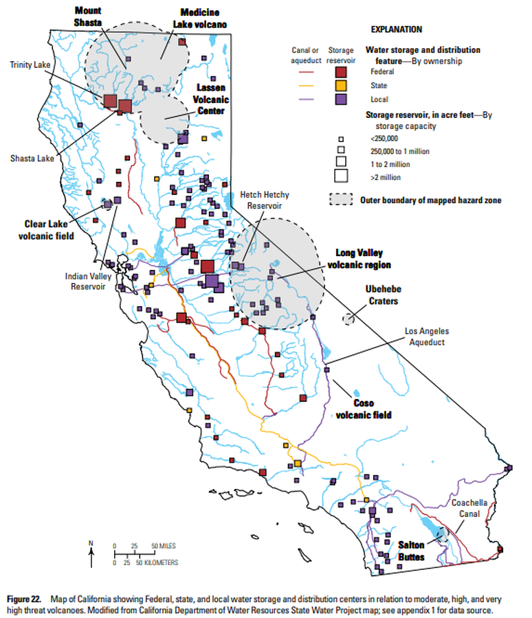
Map of California showing Federal, state, and local water storage and distribution centers in relation to moderate, high, and very high threat volcanoes
Figure 22 in: Mangan, M., Ball, J., Wood, N., Jones, J.L., Peters, J., Abdollahian, N., Dinitz, L., Blankenheim, S., Fenton, J., & Pridmore, C. (2019). California’s exposure to volcanic hazards. U.S. Geological Survey Scientific Investigations Report 2018–5159, v. 1.1, 49 p. https://doi.org/10.3133/sir20185159
Official, Figure in hazard assessment
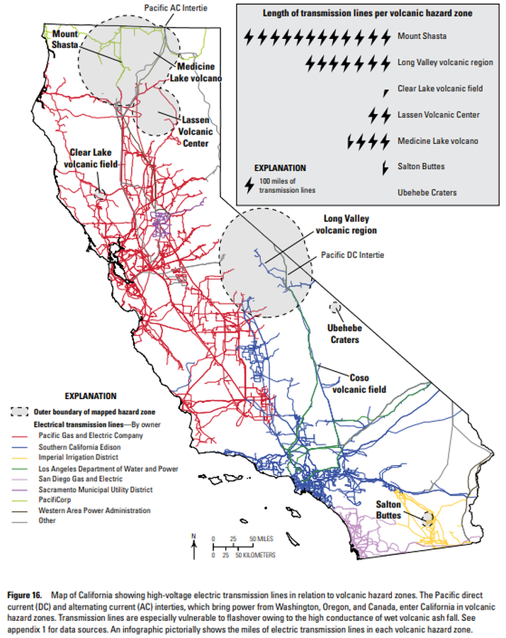
Map of California showing high-voltage electric transmission lines in relation to volcanic hazard zones
Figure 16 in: Mangan, M., Ball, J., Wood, N., Jones, J.L., Peters, J., Abdollahian, N., Dinitz, L., Blankenheim, S., Fenton, J., & Pridmore, C. (2019). California’s exposure to volcanic hazards. U.S. Geological Survey Scientific Investigations Report 2018–5159, v. 1.1, 49 p. https://doi.org/10.3133/sir20185159
Official, Figure in hazard assessment
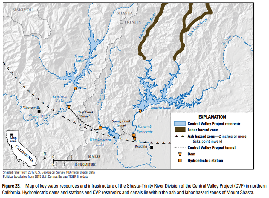
Map of key water resources and infrastructure of the Shasta-Trinity River Division of the Central Valley Project (CVP) in northern California
Figure 23 in: Mangan, M., Ball, J., Wood, N., Jones, J.L., Peters, J., Abdollahian, N., Dinitz, L., Blankenheim, S., Fenton, J., & Pridmore, C. (2019). California’s exposure to volcanic hazards. U.S. Geological Survey Scientific Investigations Report 2018–5159, v. 1.1, 49 p. https://doi.org/10.3133/sir20185159
Official, Figure in hazard assessment
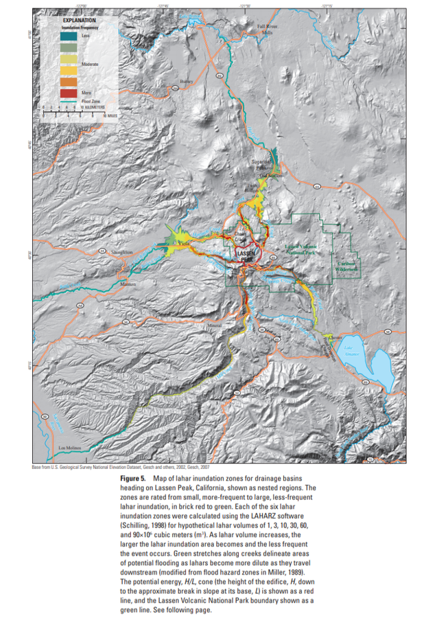
Map of lahar inundation zones for drainage basins
Figure 5 in: Robinson, J. E. & Clynne, M. A. (2012). Lahar Hazard Zones for Eruption-Generated Lahars in the Lassen Volcanic Center, California. U.S. Geological Survey Scientific Investigations Report , 2012-5176-C, 13 p. https://doi.org/10.3133/sir20125176C
Official, Figure in hazard assessment
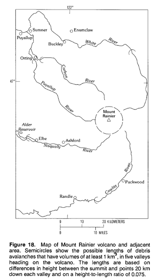
Map of Mount Rainier volcano and adjacent area.
Figure 18 in: Crandell, D.R. (1989). Gigantic debris avalanche of Pleistocene age from ancestral Mount Shasta Volcano, California, and debris-avalanche hazard zonation. U.S. Geological Survey, Bulletin 1861, 32 p. https://doi.org/10.3133/b1861
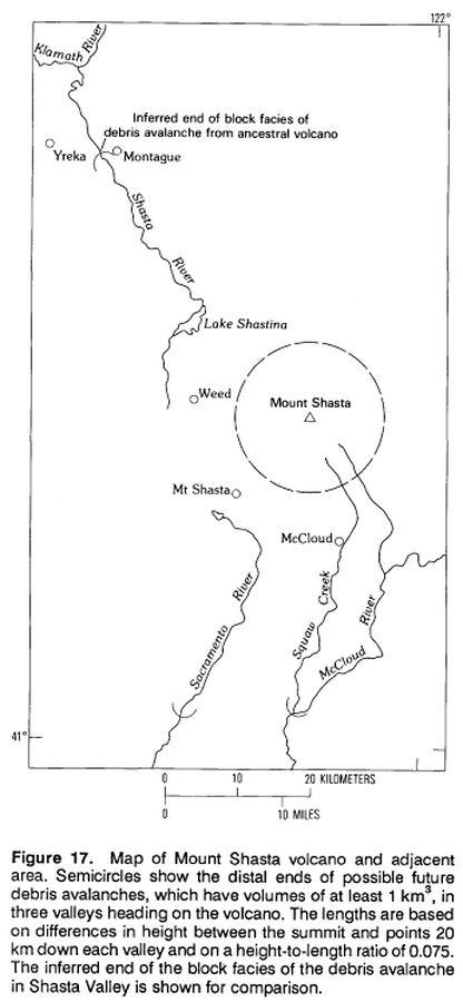
Official, Figure in hazard assessment
Map of Mount Shasta volcano and adjacent area.
Figure 17 in: Crandell, D.R. (1989). Gigantic debris avalanche of Pleistocene age from ancestral Mount Shasta Volcano, California, and debris-avalanche hazard zonation. U.S. Geological Survey, Bulletin 1861, 32 p. https://doi.org/10.3133/b1861