
Advanced Search for Maps
Showing 31-40 of 728
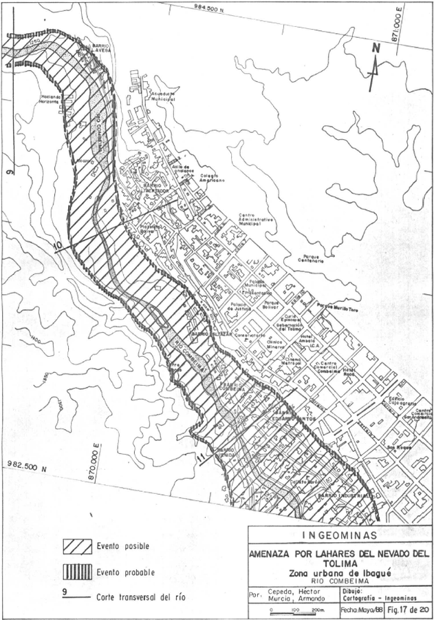
Official, Figure in hazard assessment
Amenaza por Lahares del Volcan Nevado del Tolima, Zona Urbana de Ibagué, Rio Combeima
(Hazards from Lahars of Nevado del Tolima Volcano, Ibagué Urban Zone, Combeima River)
Figure 17 in: Cepeda, H. & Murcia, A. (1988). Mapa Preliminar de Amenaza Volcanica Potencial del Nevado del Tolima, Colombia, S.A. Instituto Nacional de Investigaciones Geologico-Mineras (INGEOMINAS). Medellin.
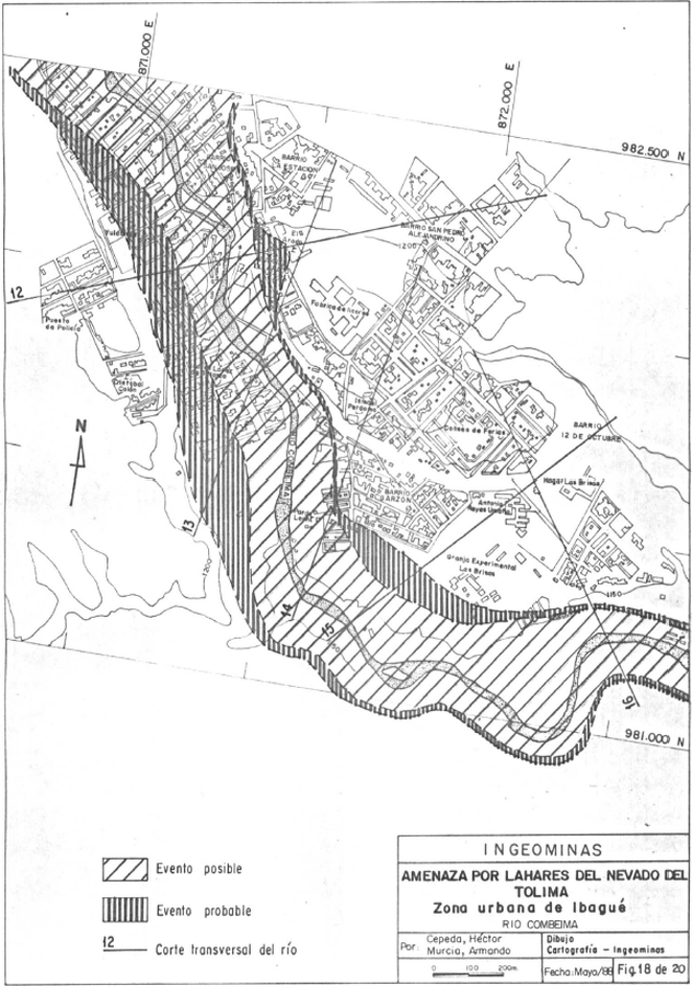
Official, Figure in hazard assessment
Amenaza por Lahares del Volcan Nevado del Tolima, Zona Urbana de Ibagué, Rio Combeima
(Hazards from Lahars of Nevado del Tolima Volcano, Ibagué Urban Zone, Combeima River)
Figure 18 in: Cepeda, H. & Murcia, A. (1988). Mapa Preliminar de Amenaza Volcanica Potencial del Nevado del Tolima, Colombia, S.A. Instituto Nacional de Investigaciones Geologico-Mineras (INGEOMINAS). Medellin.
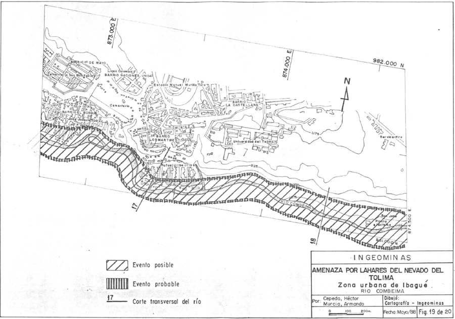
Official, Figure in hazard assessment
Amenaza por Lahares del Volcan Nevado del Tolima, Zona Urbana de Ibagué, Rio Combeima
(Hazards from Lahars of Nevado del Tolima Volcano, Ibagué Urban Zone, Combeima River)
Figure 19 in: Cepeda, H. & Murcia, A. (1988). Mapa Preliminar de Amenaza Volcanica Potencial del Nevado del Tolima, Colombia, S.A. Instituto Nacional de Investigaciones Geologico-Mineras (INGEOMINAS). Medellin.
Nevado del Tolima, Colombia
Official, Figure in hazard assessment
Amenaza por Lahares del Volcan Nevado del Tolima, Zona Urbana de Ibagué, Rio Combeima
(Hazards from Lahars of Nevado del Tolima Volcano, Ibagué Urban Zone, Combeima River)
Figure 20 in: Cepeda, H. & Murcia, A. (1988). Mapa Preliminar de Amenaza Volcanica Potencial del Nevado del Tolima, Colombia, S.A. Instituto Nacional de Investigaciones Geologico-Mineras (INGEOMINAS). Medellin.
Official, Flyer, brochure, short fact-sheet, or handout
Aogashima Volcanic Alert Levels
Japan Meteorological Agency. (2018). Aogashima Volcanic Alert Levels. Volcano Monitoring and Warning Center, Volcano Division, Earthquake and Volcano Department.

Official, Sign or billboard
Area closed. Do not enter. Increased risk of eruption.
Department of Conservation. (2020). Area closed. Do not enter. Increased risk of eruption. December 2020 R183230.
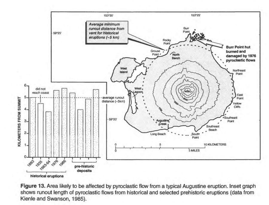
Official, Figure in hazard assessment
Area likely to be affected by pyroclastic flow from a typical Augustine eruption
Figure 13 in: Waythomas, C.F. & Waitt, R. (1998). Preliminary volcano-hazard assessment for Augustine Volcano, Alaska. U.S. Geological Survey, Open-File Report 98-106. https://doi.org/10.3133/ofr98106
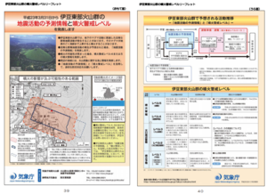
Official, Figure in hazard assessment
Area where the crater may appear and area where eruptions may affect
Page 18 in: Shizuoka Prefecture and Volcano Disaster Prevention Measure Deliberation Committee at Izu-Tobu Volcanoes. (2011). Volcano disaster prevention measure deliberation committee report at Izu-Tobu Volcanoes. Emergency Management Information Division, Shizuoka Prefecture.
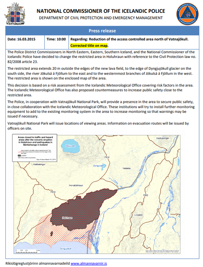
Official, Map in an information statement
Areas closed to traffic and hazard areas after the volcanic eruption in Holuhraun and earthquakes in Bárðarbunga in Iceland
National Commisioner of the Icelandic Police. (2015). Press Release 16.03.2015 10:00 Regarding: Reduction of the access controlled area north of Vatnajökull.
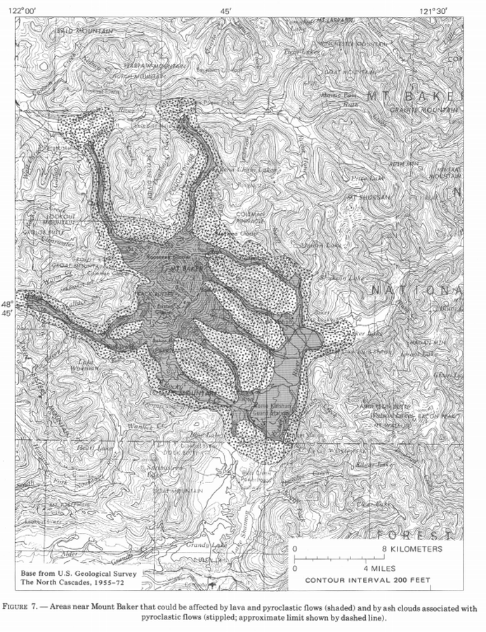
Official, Figure in hazard assessment
Areas near Mount Baker that could be affected by lava and pyroclastic flows (shaded) and by ash clouds associated with pyroclastic flows (stippled; approximate limit shown by dashed line)
Figure 7 in: Hyde, J. & Crandell, D.R. (1978). Postglacial volcanic deposits at Mount Baker, Washington, and potential hazards from future eruptions. U.S. Geological Survey, Professional Paper 1022-C, C1-C17, 1 plate in pocket. https://doi.org/10.3133/pp1022C