
Advanced Search for Maps
Showing 61-70 of 728
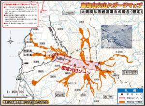
Official, Map in a booklet, long fact-sheet, or handbook
Chokaisan Hazard Map - In case of large scale lava flow eruption
Page 12 in: Volcano Disaster Management Councils of Chokaisan. (2019). Chokaisan Volcanic Disaster Prevention Map.
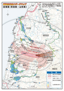
Official, Map in a booklet, long fact-sheet, or handbook
Chokaisan Hazard Map - Whole Area Version (Akita/Yamagata)
Page 13-14 in: Volcano Disaster Management Councils of Chokaisan. (2019). Chokaisan Volcanic Disaster Prevention Map.
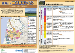
Official, Flyer, brochure, short fact-sheet, or handout
Chokaisan Volcanic Alert Levels
Japan Meteorological Agency. (2018). Chokaisan Volcanic Alert Levels. Volcano Monitoring and Warning Center, Volcano Division, Earthquake and Volcano Department.
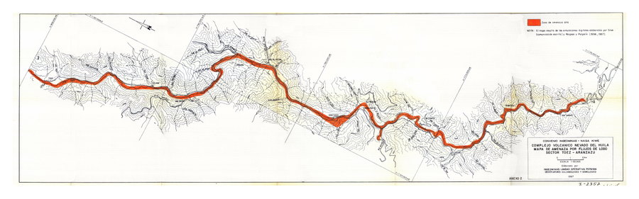
Official, Insert/poster-size map with accompanying report
Complejo Volcanico Nevado del Huila Mapa de Amenaza por Flujos de Lodo Sector Toez - Aranzazu
(Nevado del Huila Volcanic Complex Mudflow Hazard Map Sector Toez - Aranzazu)
Anexo 2 in: Instituto Colombiano de Geología y Minería (INGEOMINAS). (1996). Evaluación de Amenaza y Vigilancia Volcánica del Complejo Volcánico Nevado del Huila. Popayan.
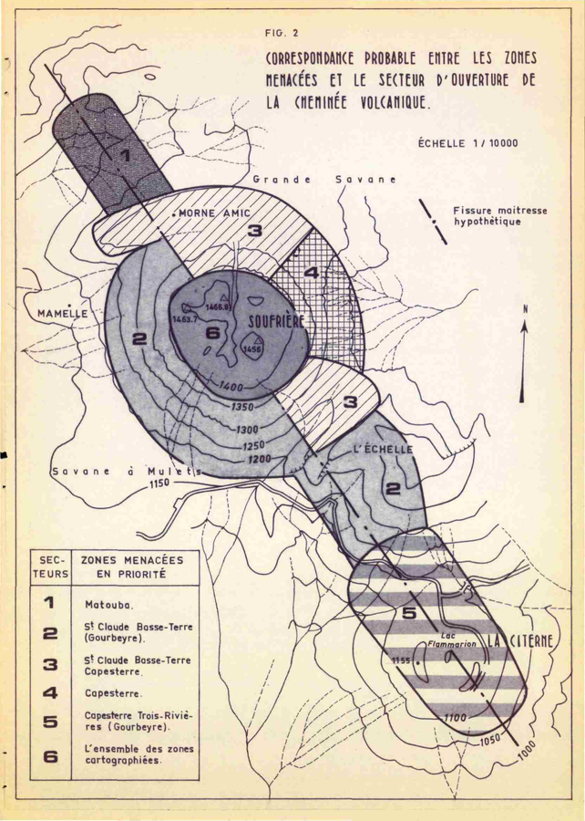
Official, Figure in hazard assessment
Correspondance Probable Entre les Zones Menacées et le Secteur d'Ouverture de la Cheminée Volcanique
(Probable Correspondence Between the Endangered Zones and the Opening Sector of the Volcanic Chimney)
Figure 2 in: Westercamp, D. (1976). Dynamismes Éruptifs et Zonation des Risques Volcaniques a la Sourfrière de Guadeloupe. Bureau de Recherches Géologiques, Service Geologique des Antilles.
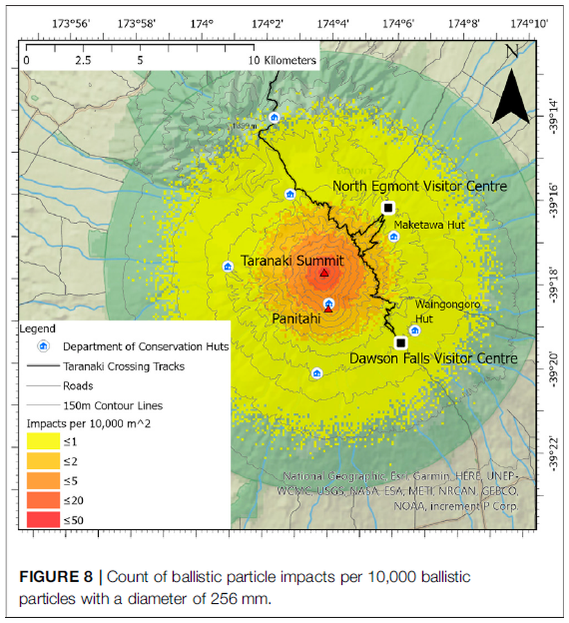
Figure in a journal article
Count of ballistic particle impacts per 10,000 ballistic particles with a diameter of 256 mm
Figure 8 in: Mead, S., Procter, J., Bebbington, M., & Rodriguez-Gomez, C. (2022). Probabilistic Volcanic Hazard Assessment for National Park Infrastructure Proximal to Taranaki Volcano (New Zealand). Frontiers in Earth Science, 435. https://doi.org/10.3389/feart.2022.832531
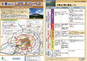
Official, Flyer, brochure, short fact-sheet, or handout
Daisetsusan Volcanic Alert Levels
Japan Meteorological Agency. (2019). Daisetsusan Volcanic Alert Levels. Volcano Monitoring and Warning Center, Volcano Division, Earthquake and Volcano Department.
Official, Map in a booklet, long fact-sheet, or handbook
Debris flow dangerous area prediction map
Page 8 in: Nasudake Volcano Disaster Prevention Council. (2014). Nasudake Volcano Disaster Prevention Handbook.
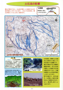
Official, Map in a booklet, long fact-sheet, or handbook
Debris flow dangerous area prediction map
Page 8 in: Nasudake Volcano Disaster Prevention Council. (2010). Volcanic disaster prevention handbook of Mt. Nasudake.
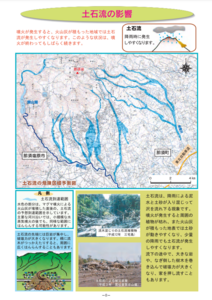
Official, Figure in hazard assessment
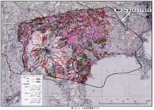
Debris flow possibility map
Figure 5.7.1 in: Mt. Fuji Hazard Map Review Committee. (2004). Mt. Fuji Hazard Map Review Committee Report. June 2004. https://www.bousai.go.jp/kazan/fuji_map/pdf/report_200406.pdf