
Advanced Search for Maps
Showing 41-50 of 728
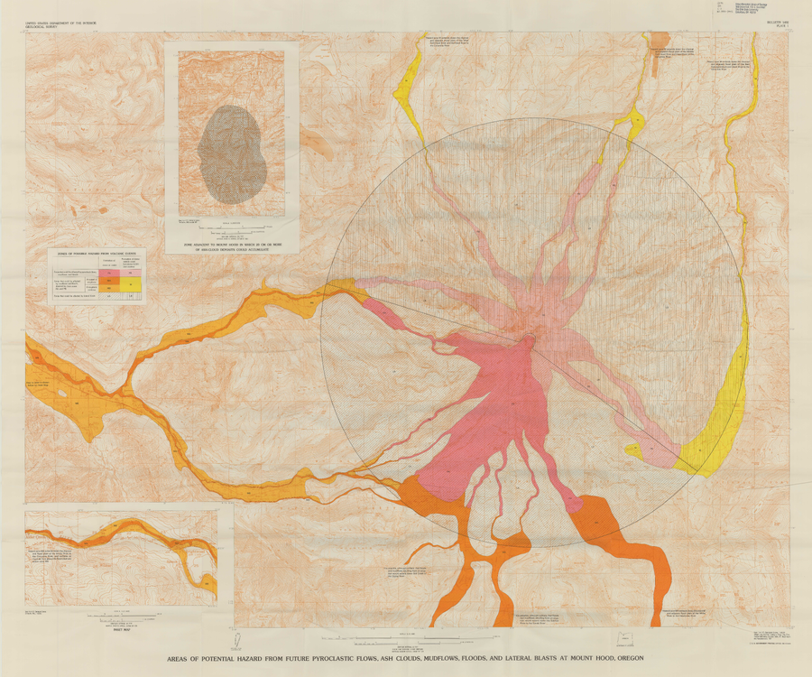
Official, Insert/poster-size map with accompanying report
Areas of Potential Hazard from Future Pyroclastic Flows, Ash Clouds, Mudflows, and Lateral Blasts at Mount Hood, Oregon
Plate 1 in: Crandell, D.R. (1980). Recent eruptive history of Mount Hood, Oregon, and potential hazards from future eruptions. U.S. Geological Survey, Bulletin 1492, 81 p. https://doi.org/10.3133/b1492
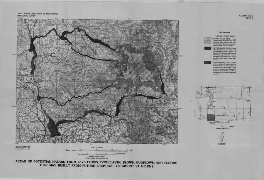
Official, Insert/poster-size map with accompanying report
Areas of Potential Hazard from Lava Flows, Pyroclastic Flows, Mudflows, and Floods that May Result from Future Eruptions of Mount St. Helens
Plate 2 in: Crandell, D.R. & Mullineaux, D.R. (1978). Potential Hazards from Future Eruptions of Mount St. Helens Volcano, Washington. U.S. Geological Survey, Bulletin 1383-C, 26 p. https://doi.org/10.3133/b1383C
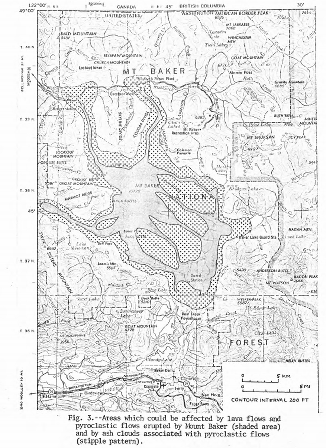
Official, Figure in hazard assessment
Areas which could be affected by lava flows and pyroclastic flows erupted from Mount Baker and by ash clouds associated with pyroclastic flows
Figure 3 in: Hyde, J.H. & Crandell, D.R. (1975). Origin and age of postglacial deposits and assessment of potential hazards from future eruptions of Mount Baker, Washington. U.S. Geological Survey, Open-File Report 75-286, 22 p. https://doi.org/10.3133/ofr75286
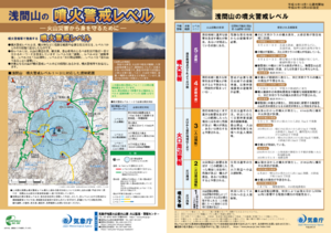
Official, Flyer, brochure, short fact-sheet, or handout
Asamayama Volcanic Alert Levels
Japan Meteorological Agency. (2016). Asamayama Volcanic Alert Levels. Volcano Monitoring and Warning Center, Volcano Division, Earthquake and Volcano Department.
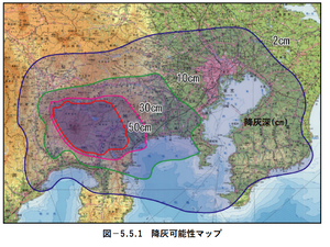
Official, Figure in hazard assessment
Ash fall possibility map
Figure 5.5.1 in: Mt. Fuji Hazard Map Review Committee. (2004). Mt. Fuji Hazard Map Review Committee Report. June 2004. https://www.bousai.go.jp/kazan/fuji_map/pdf/report_200406.pdf
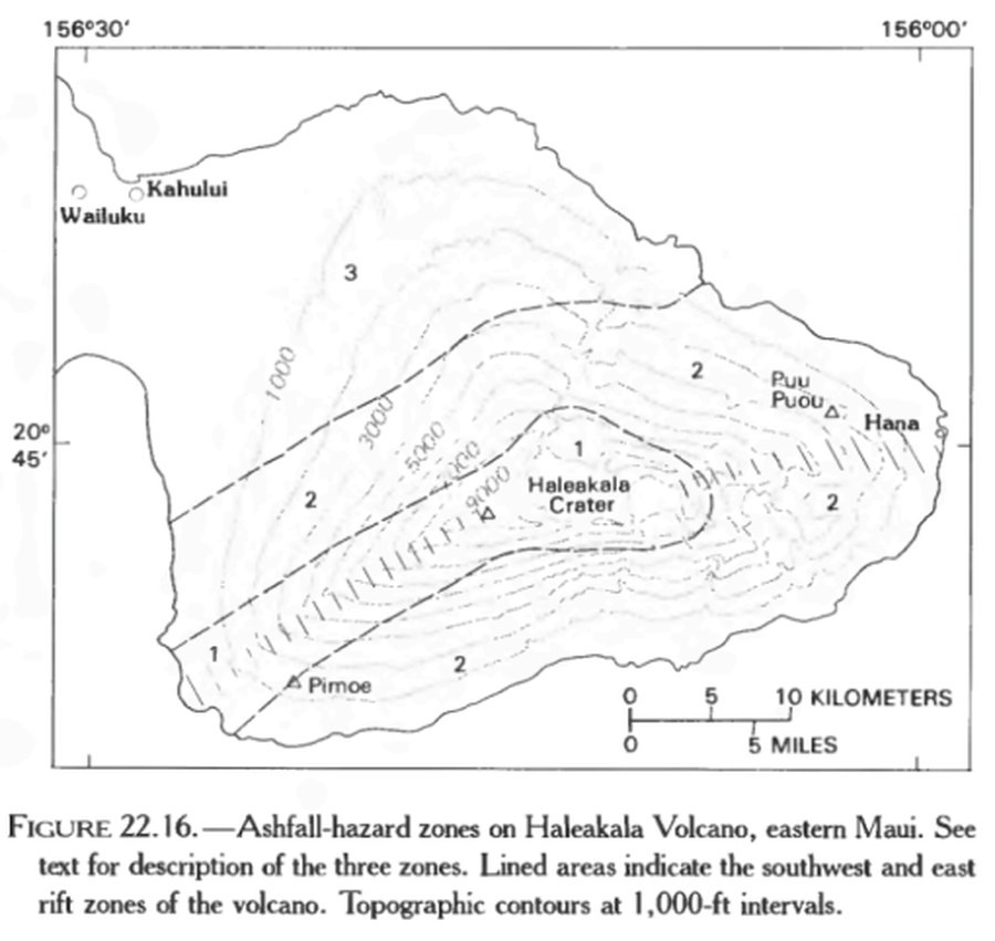
Official, Figure in hazard assessment
Ashfall-hazard zones on Haleakala Volcano, eastern Maui.
Figure 22.16 in: Mullineaux, D.R., Peterson, D.W., & Crandell, D.R. (1987). Volcanic hazards in the Hawaiian Islands. In: Decker, R.W., Wright, T.L., & Stauffer, P.H. (Eds.) Volcanism in Hawaii. US Geological Survey Professional Paper 1350, Chapter 22, p. 599-621. https://doi.org/10.3133/pp1350
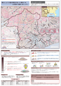
Official, Map sheet or poster
Ashigarakami District Volcanic Disaster Prevention Map
Figure 6.3.14 in: Mt. Fuji Hazard Map Review Committee. (2004). Mt. Fuji Hazard Map Review Committee Report. June 2004. https://www.bousai.go.jp/kazan/fuji_map/pdf/report_200406.pdf
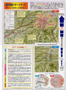
Official, Flyer, brochure, short fact-sheet, or handout
Ashoro Town Meakan-dake Disaster Prevention Map
Ashoro Town. (2000). Ashoro Town Meakan-dake Disaster Prevention Map.
Fujisan, Japan
Official, Figure in hazard assessment
Assumed crater range for each scale
Figure 4.1.4 in: Mt. Fuji Hazard Map Review Committee. (2004). Mt. Fuji Hazard Map Review Committee Report. June 2004. https://www.bousai.go.jp/kazan/fuji_map/pdf/report_200406.pdf
Official, Figure in hazard assessment
Assumed crater range for each scale
Figure 4.1.4 in: Mt. Fuji Hazard Map Review Committee. (2004). Mt. Fuji Hazard Map Review Committee Report. June 2004. https://www.bousai.go.jp/kazan/fuji_map/pdf/report_200406.pdf
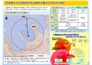
Official, Map in a booklet, long fact-sheet, or handbook
Assumed future eruption location and magnitude of eruption
Page 7 in: Towada Volcanic Hazards Mitigation Committee. (2018). Towada Volcano Hazard Expected Impact Area Map. Omori Prefecture Disaster Risk Management Division, Akita Prefecture Disaster Prevention Division, Nagano City General Affairs Division, Kosaka Town General Affairs Division.