
Advanced Search for Maps
Showing 21-30 of 78
Official (foreign agency), Insert/poster-size map with accompanying report
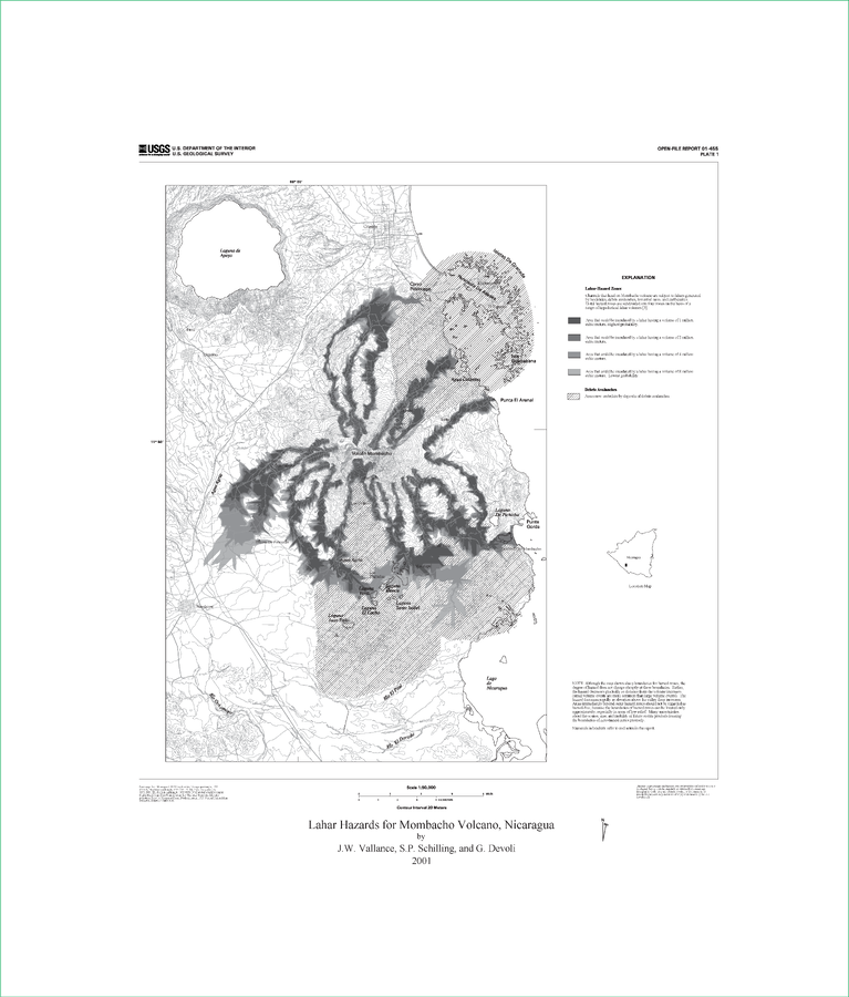
Lahar Hazards for Mombacho Volcano, Nicaragua
Plate 1 (B&W) in: Vallance, J.W., Schilling, S.P., Devoli, G. (2001). Lahar Hazards at Mombacho Volcano, Nicaragua. U.S. Geological Survey, Open-File Report 01-455, 16 p., 1 plate. https://doi.org/10.3133/ofr01455
Official (foreign agency), Insert/poster-size map with accompanying report
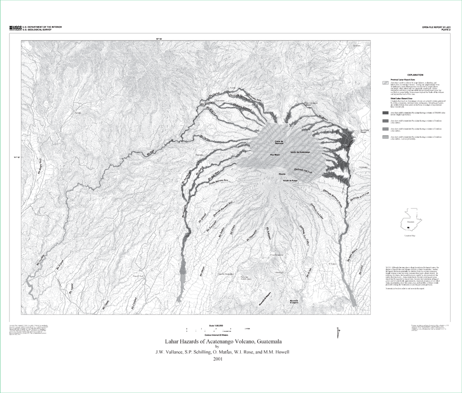
Lahar Hazards of Acatenango Volcano, Guatemala
Plate 2 in: Vallance, J.W., Schilling, S.P., Matías, O., Rose, W.I. & Howell, M.M. (2001). Volcano Hazards at Fuego and Acatenango, Guatemala. U.S. Geological Survey, Open-File Report 01-431. https://doi.org/10.3133/ofr01431
Official (foreign agency), Insert/poster-size map with accompanying report
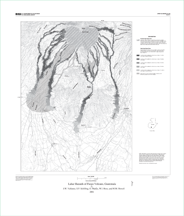
Lahar Hazards of Fuego Volcano, Guatemala
Plate 1 (B&W) in: Vallance, J.W., Schilling, S.P., Matías, O., Rose, W.I. & Howell, M.M. (2001). Volcano Hazards at Fuego and Acatenango, Guatemala. U.S. Geological Survey, Open-File Report 01-431. https://doi.org/10.3133/ofr01431
Official, Figure on website
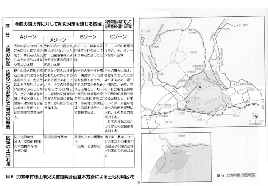
Land use area map. Land use areas according to the basic policy of the 2000 Mt. Usu eruption disaster recovery plan.
Figure 8-9 in: Nakao, M. (2005). Eruption of Mt Usu, March 31 st 2000, at Mt Usu in Hokkaido. In: Failure Knowledge Database, 100 Selected Cases. http://www.shippai.org/fkd/en/cfen/CA1000619.html. Reprinted from: The Hokkaido Shimbun Press. (2002) 2000-Nen Usu-Zan Funka (The 2000 Mt. Usu Eruption). The Hokkaido Shimbun Press.

Official, Figure in hazard assessment
Localisation des Secteurs Susceptibles de Glisser sous L'action des Explosions Phréatiques ou des Secousses Sismiques Superficielles
(Location of Sectors Likely to Slip Under the Action of Ground Explosions or Superficial Earthquakes)
Figure 13 in: Westercamp, D. (1977) Levés géologiques, évaluation et zonation des risques volcaniques à la Soufrière de Guadeloupe F. W. I. (Rapport de mission) Mai-Juin 1977. Délégation Générale a la Recherche Scientifique et Technique. 77 Ant 29
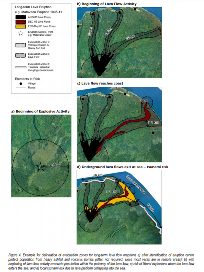
Official, Figure in hazard assessment
Long-term Lava Eruption e.g. Matavanu Eruption 1905-11
Figure 4 in: Cronin, S., Bonte-Grapentin, M. & Nemeth, K. (2006). Samoa technical report - Review of volcanic hazard maps for Savai'i and Upolu. Pacific Islands Applied Geoscience Commission (SOPAC) Project Report 59.
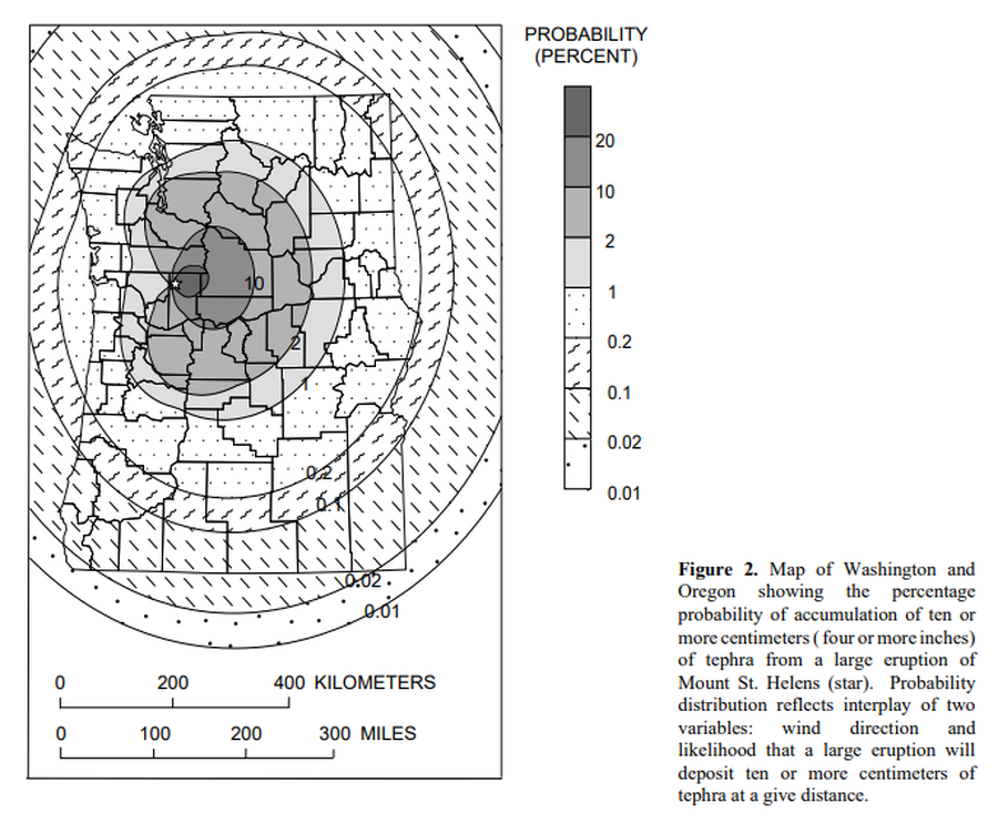
Official, Figure in hazard assessment
Map of Washington and Oregon showing the percentage probability of accumulation of ten or more centimeters (four or more inches) of tephra from a large eruptions of Mount St. Helens.
Figure 2 in: Wolfe, E.W. & Pierson, T.C. (1995). Volcanic-Hazard Zonation for Mount St. Helens, Washington, 1995. U.S. Geological Survey, Open-File Report 95-497, 12 p., 1 plate. https://doi.org/10.3133/ofr95497
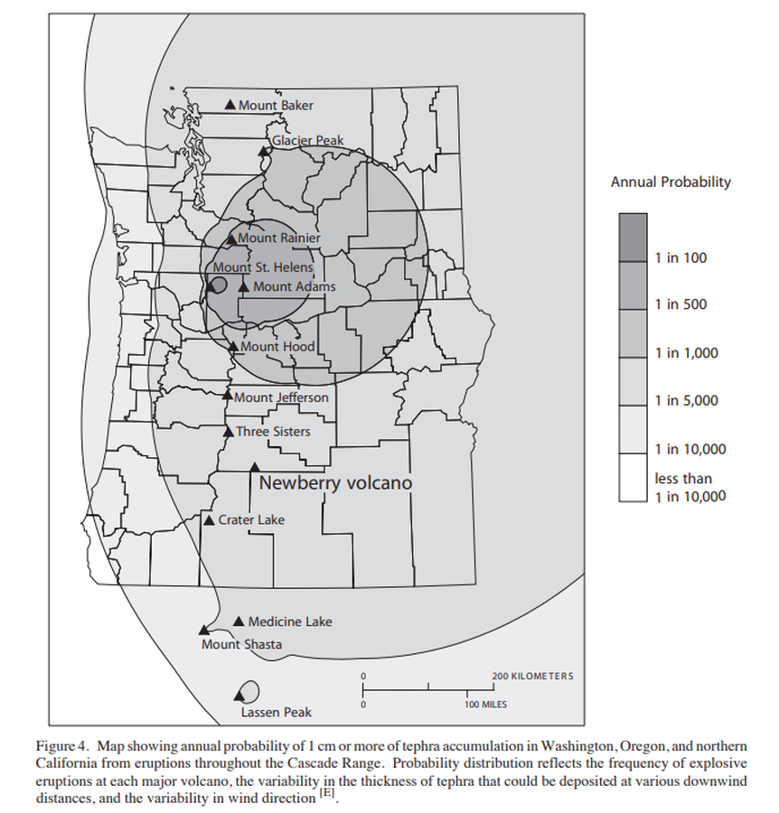
Official, Figure in hazard assessment
Map showing annual probability of 1 cm or more of tephra accumulation in Washington, Oregon, and northern California from eruptions throughout the Cascade Range.
Figure 4 in: Sherrod, D.R., Mastin, L.G., Scott, W.E. & Schilling, S.P. (1997). Volcano hazards at Newberry Volcano, Oregon. U.S. Geological Survey, Open-File Report 97-513, 14 p. https://doi.org/10.3133/ofr97513
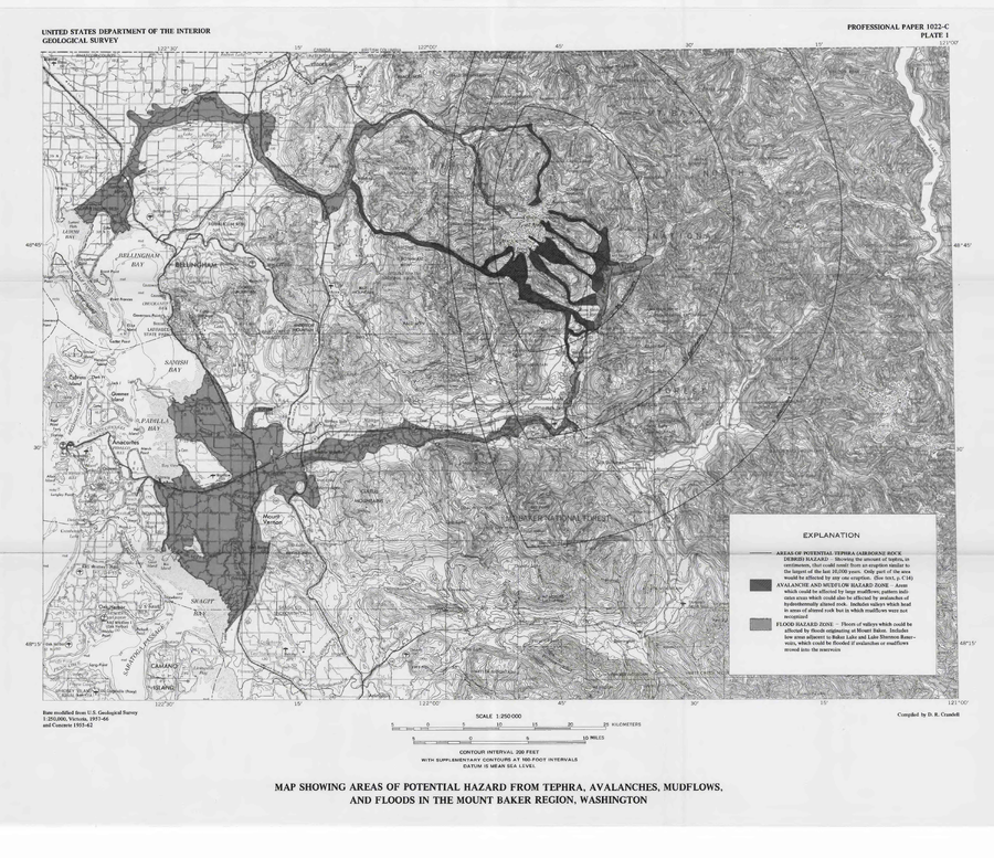
Official, Insert/poster-size map with accompanying report
Map Showing Areas of Potential Hazard from Tephra, Avalanches, Mudflows, and Floods in the Mount Baker Region, Washington
Plate 1 in: Hyde, J. & Crandell, D.R. (1978). Postglacial volcanic deposits at Mount Baker, Washington, and potential hazards from future eruptions. U.S. Geological Survey, Professional Paper 1022-C, C1-C17, 1 plate in pocket. https://doi.org/10.3133/pp1022C
Official, Figure in hazard assessment
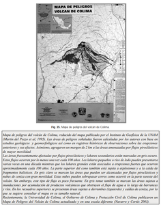
Mapa de peligros del volcán de Colima
(Colima Volcano hazard map)
de la Cruz Reyna, S. (2008). Volcanes. Peligro y Riesgo Volcánico en México. Serie Fascículos. Secretaria de Gobernación. CENAPRED, México. (Modified from: Martin del Pozzo et al. 1995)