
Advanced Search for Maps
Showing 11-20 of 78
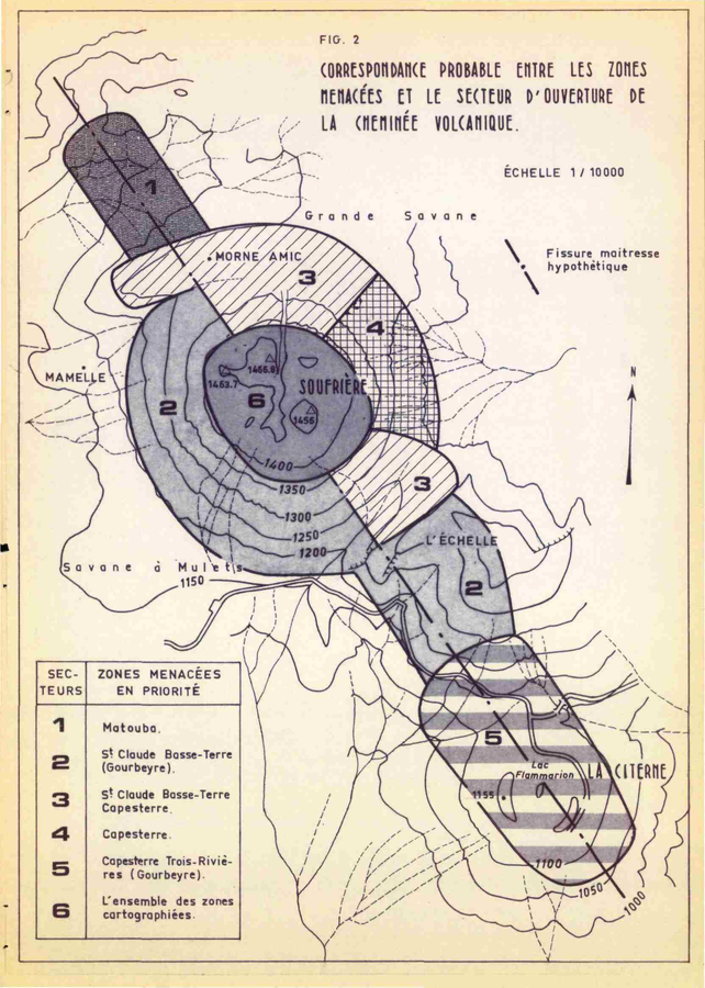
Official, Figure in hazard assessment
Correspondance Probable Entre les Zones Menacées et le Secteur d'Ouverture de la Cheminée Volcanique
(Probable Correspondence Between the Endangered Zones and the Opening Sector of the Volcanic Chimney)
Figure 2 in: Westercamp, D. (1976). Dynamismes Éruptifs et Zonation des Risques Volcaniques a la Sourfrière de Guadeloupe. Bureau de Recherches Géologiques, Service Geologique des Antilles.
Holuhraun (Askja) & Bárdarbunga, Iceland
Official, Map in an information statement
Dæmi um verulegt sprengigos í Dyngjujökli, jafnþykktarlínur gjóskufalls
(Example of a major explosive eruption in Dyngjujökli, equal thickness lines of tephra)
Kort Jarðvísindastofnun HÍ. (2014). Dæmi um verulegt sprengigos í Dyngjujökli, jafnþykktarlínur gjóskufalls.
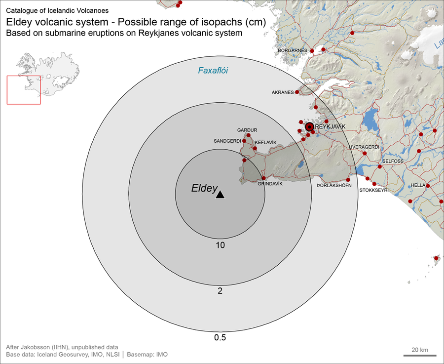
Official, Figure on website
Eldey volcanic system - Possible range of isopachs (cm). Based on submarine eruptions on Reykjanes volcanic system
Larsen, G. (2019). Eldey. In: Oladottir, B., Larsen, G. & Guðmundsson, M. T. Catalogue of Icelandic Volcanoes. Iceland Meteorological Office (IMO), Univeristy of Iceland, and Civil Protection Department of the National Commissioner of the Iceland Police (CPD-NCIP). https://icelandicvolcanos.is//index.html (Simplified from: S.P. Jakobsson Unpublished data)
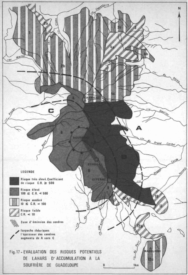
Official, Figure in hazard assessment
Evaluation des Risques Potentiels de Lahars d'Accumulation a la Soufrière de Guadeloupe
(Assessment of the Potential Risks of Lahars of Accumulation at the Soufriere of Guadeloupe)
Figure 17 in: Westercamp, D. (1977) Levés géologiques, évaluation et zonation des risques volcaniques à la Soufrière de Guadeloupe F. W. I. (Rapport de mission) Mai-Juin 1977. Délégation Générale a la Recherche Scientifique et Technique. 77 Ant 29
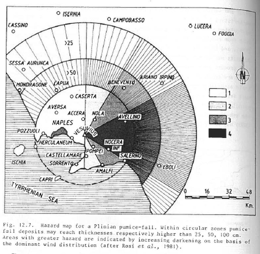
Figure in a journal article
Hazard map for a Plinian pumice-fall
Figure 12.7 in: Barberi, F., Rosi, M., Santacroce, R., & Sheridan, M.F. (1983). Volcanic hazard zonation: Mt. Vesuvius. In: Tazieff, H. & Sabroux, J.-C. (Eds.) Forecasting Volcanic Events, Elsevier, Amsterdam, p. 149-161.
Official, Figure in a journal article
Hazards map of pyroclastic flows produced by central dome explosions based on four recognized events during the past 40 k.y., and small-size landslides produced by flank instability, and debris and hyperconcentrated flows produced by syneruptive or posteruptive processes.
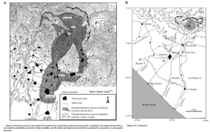
Figure 14 in: Macias, J. L., Espíndola, J. M., Garcia-Palomo, A., Scott, K. M., Hughes, S., & Mora, J. C. (2000). Late Holocene Peléan-style eruption at Tacaná volcano, Mexico and Guatemala: Past, present, and future hazards. Geological Society of America Bulletin, 112(8), p. 1234-1249. https://doi.org/10.1130/0016-7606(2000)112%3C1234:LHPEAT%3E2.0.CO;2
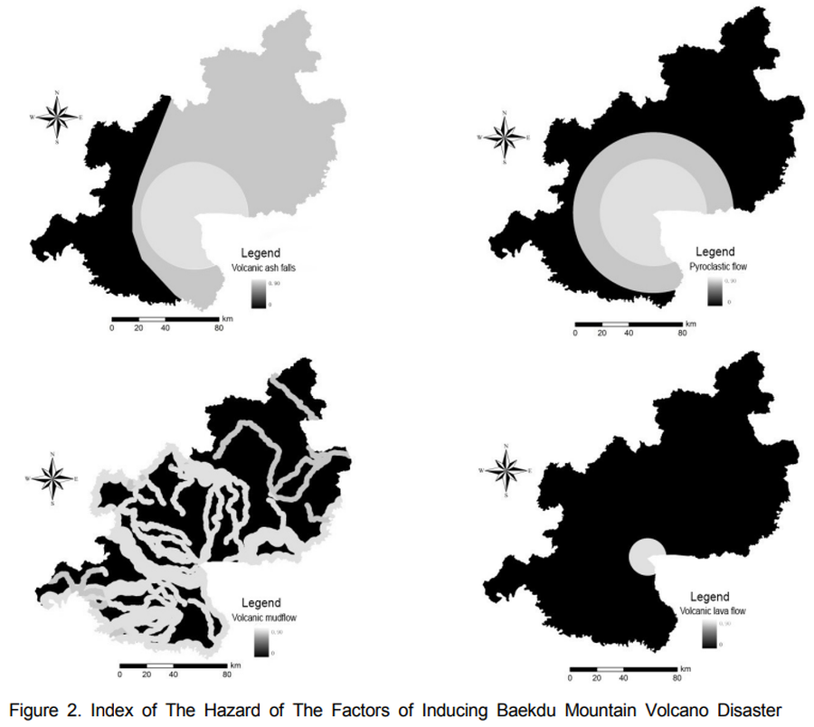
Figure in a journal article
Index of The Hazard of The Factors of Inducing Baekdu Mountain Volcano Disaster
Figure 2 in: Xiao-Jiao, N., Choi, Y. S., & Ying, N. (2014). A Study on Integrated Assessment of Baekdu Mountain Volcanic Aisaster risk Based on GIS. Journal of Korea Spatial Information Society. Korea Spatial Information Society. https://doi.org/10.12672/ksis.2014.22.4.077
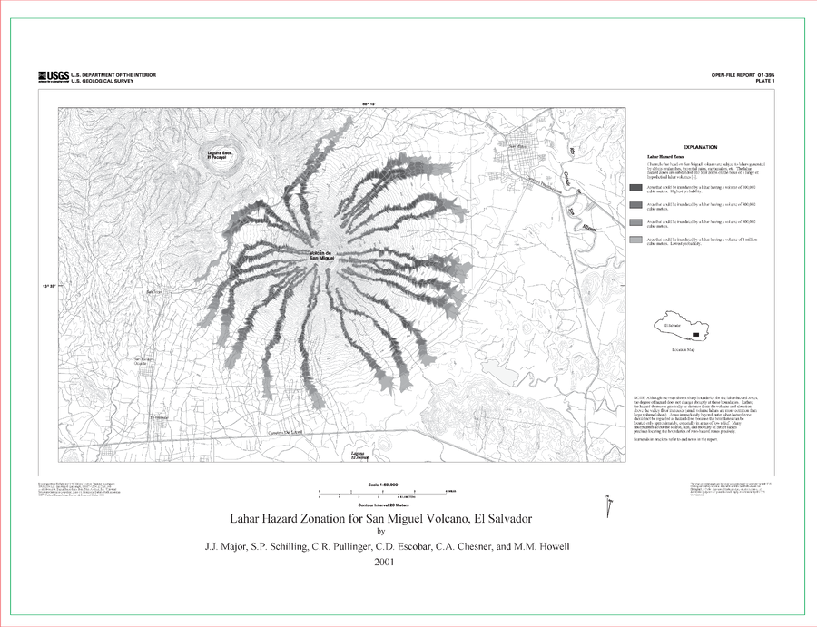
Official (foreign agency), Insert/poster-size map with accompanying report
Lahar Hazard Zonation for San Miguel Volcano, El Salvador
Plate 1 in: Major, J.J., Schilling, S.P., Pullinger, C.R., Escobar, C.D., Chesner, C.A., & Howell, M.M. (2001). Lahar-Hazard Zonation for San Miguel Volcano, El Salvador. U.S. Geological Survey, Open-File Report 2001-395, 16 p., 1 plate. https://doi.org/10.3133/ofr01395
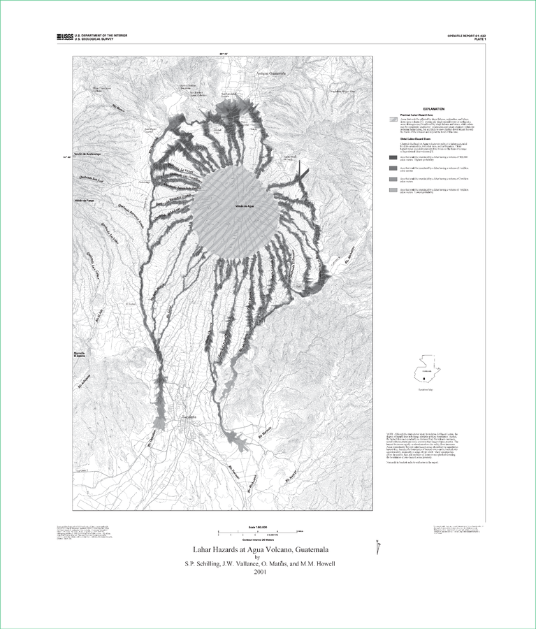
Official (foreign agency), Insert/poster-size map with accompanying report
Lahar Hazards at Agua Volcano, Guatemala
Plate 1 in: Schilling, S.P., Vallance, J.W., Matías, O., & Howell, M.M. (2001). Lahar Hazards at Agua Volcano, Guatemala. U.S. Geological Survey, Open-File Report 01-432, 16 p., 1 plate. https://doi.org/10.3133/ofr01432
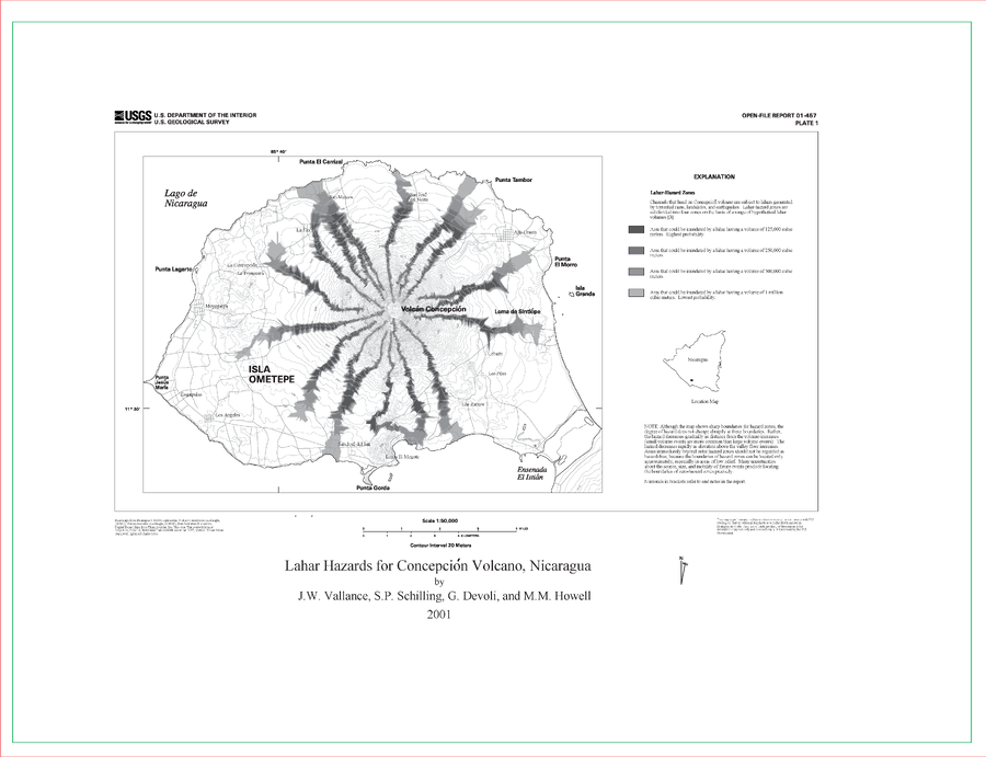
Official (foreign agency), Insert/poster-size map with accompanying report
Lahar Hazards for Concepción Volcano, Nicaragua
Plate 1 in: Vallance, J.W., Schilling, S.P., Devoli, G., & Howell, M.M. (2001). Lahar hazards at Concepción volcano, Nicaragua. U.S. Geological Survey, Open File Report 2001-457, 15 p., 1 plate. https://doi.org/10.3133/ofr01457