
Advanced Search for Maps
Showing 71-78 of 78
Official, Insert/poster-size map with accompanying report
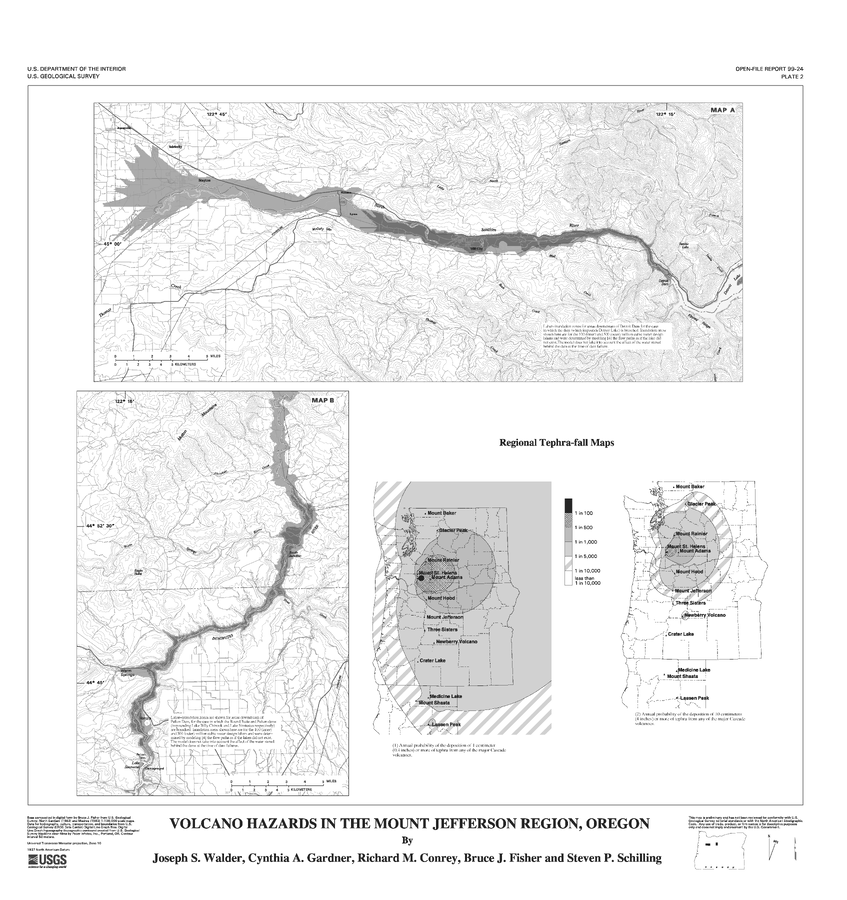
Volcano Hazards in the Mount Jefferson Region, Oregon
Plate 2 in: Walder, J.S., Gardner, C.A., Conrey, R.M., Fisher, B.J., & Schilling, S.P. (1999). Volcano Hazards in the Mount Jefferson Region, Oregon. U.S. Geological Survey, Open-File Report 99-24, 14 p. https://doi.org/10.3133/ofr9924
Official (foreign agency), Insert/poster-size map with accompanying report
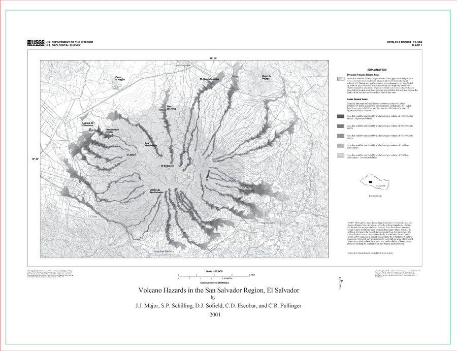
Volcano Hazards in the San Salvador Region, El Salvador
Plate 1 (B&W) in: Major, J.J., Schilling, S.P., Sofield, D.J., Escobar, C.D., & Pullinger, C.R. (2001). Volcano Hazards in the San Salvador Region, El Salvador. U.S. Geological Survey, Open-File Report 2001-366, 24 p., 2 plates. https://doi.org/10.3133/ofr01366

Official (foreign agency), Insert/poster-size map with accompanying report
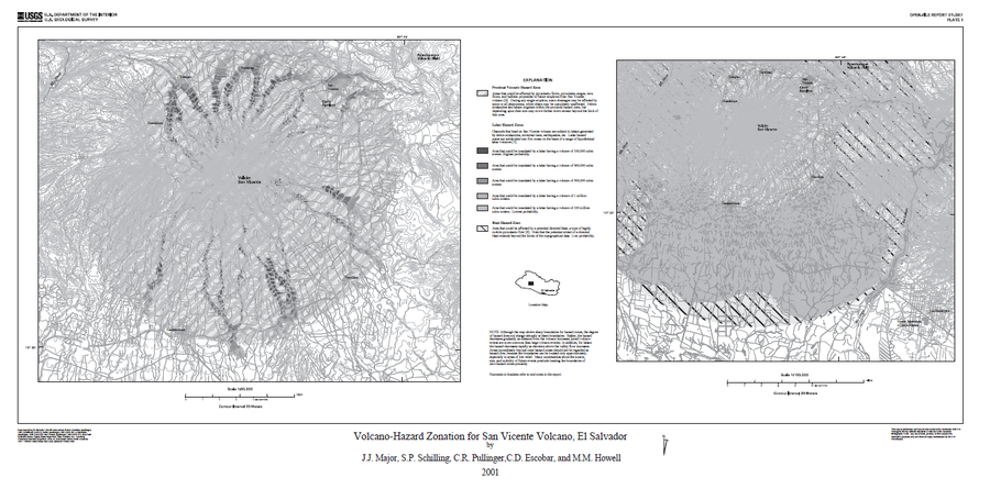
Volcano Hazards in the San Salvador Region, El Salvador
Plate 2 (B&W) in: Major, J.J., Schilling, S.P., Sofield, D.J., Escobar, C.D., & Pullinger, C.R. (2001). Volcano Hazards in the San Salvador Region, El Salvador. U.S. Geological Survey, Open-File Report 2001-366, 24 p., 2 plates. https://doi.org/10.3133/ofr01366
Official (foreign agency), Insert/poster-size map with accompanying report
Volcano-Hazard Zonation for San Vicente Volcano, El Salvador
Plate 1 in: Major, J.J., Schilling, S.P., Pullinger, C.R., Escobar, C.D., & Howell, M.M. (2001). Volcano-Hazard Zonation for San Vicente Volcano, El Salvador. U.S. Geological Survey, Open-File Report 2001-367, 22 p., 1 plate. https://doi.org/10.3133/ofr01367
Official, Figure in hazard assessment
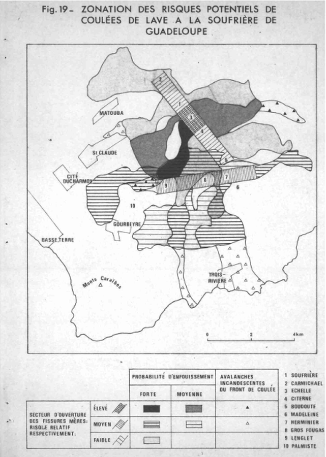
Zonation des Risques Potentiels de Coulées de Lave a la Soufriére de Guadeloupe
(Zoning of Potential Risks of Lava Flows in the Soufriere of Guadeloupe)
Figure 19 in: Westercamp, D. (1977) Levés géologiques, évaluation et zonation des risques volcaniques à la Soufrière de Guadeloupe F. W. I. (Rapport de mission) Mai-Juin 1977. Délégation Générale a la Recherche Scientifique et Technique. 77 Ant 29
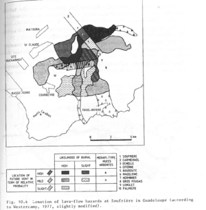
Figure in a journal article
Zonation of lava-flow hazards at Soufrière in Guadeloupe (according to Westercamp, 1977, slightly modified)
Figure 10.4 in: Westercamp, D. (1983). Appraisal and zonation of volcanic hazards in the French Lesser Antilles: preliminary results. In: Tazieff, H. & Sabroux, J.-C. (Eds.) Forecasting Volcanic Events, Elsevier, Amsterdam, p. 111-130.
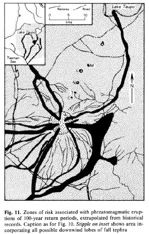
Figure in a journal article
Zones of risk associated with phreatomagmatic eruptions of 100-year return periods, extrapolated from historical records.
Figure 11 in: Houghton, B. F., Latter, J. H., & Hackett, W. R. (1987). Volcanic hazard assessment for Ruapehu composite volcano, Taupo volcanic zone, New Zealand. Bulletin of volcanology, 49(6), p. 737-751. https://doi.org/10.1007/BF01079825
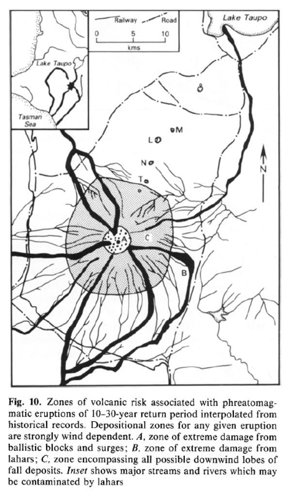
Figure in a journal article
Zones of volcanic risk associated with phreatomagmatic eruptions of 10-30-year return period interpolated from historical records.
Figure 10 in: Houghton, B. F., Latter, J. H., & Hackett, W. R. (1987). Volcanic hazard assessment for Ruapehu composite volcano, Taupo volcanic zone, New Zealand. Bulletin of volcanology, 49(6), p. 737-751. https://doi.org/10.1007/BF01079825