
Advanced Search for Maps
Showing 21-30 of 236
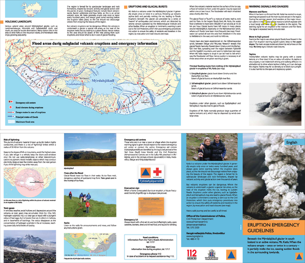
Official, Flyer, brochure, short fact-sheet, or handout
Eruption emergency guidelines – Katla in Mýrdalsjökull: English
Almannavarnir. (2017). Eruption emergency guidelines - Katla in Mýrdalsjökull.
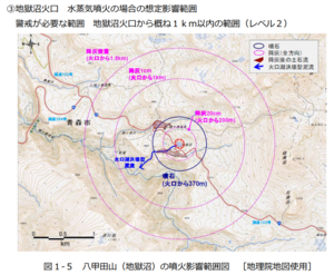
Official, Figure in hazard assessment
Eruption impact area map of Mt. Hakkoda (Jigokunuma)
Figure 1-5 in: Hakkodasan Volcanic Hazards Mitigation Committee. (2019). Hakkoda volcano evacuation plan. Aomori Prefecture, Aomori City, Towada City, Kuroishi City, and Hirakawa City.

Official, Figure in hazard assessment
Eruption impact area map of Mt. Hakkoda (Odake)
Figure 1-4 in: Hakkodasan Volcanic Hazards Mitigation Committee. (2019). Hakkoda volcano evacuation plan. Aomori Prefecture, Aomori City, Towada City, Kuroishi City, and Hirakawa City.
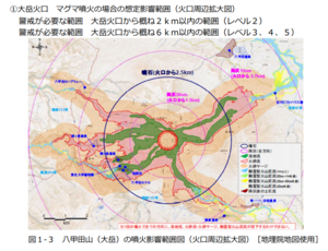
Official, Figure in hazard assessment
Eruption impact area map of Mt. Hakkoda (Odake) (Enlarged view around crater)
Figure 1-3 in: Hakkodasan Volcanic Hazards Mitigation Committee. (2019). Hakkoda volcano evacuation plan. Aomori Prefecture, Aomori City, Towada City, Kuroishi City, and Hirakawa City.
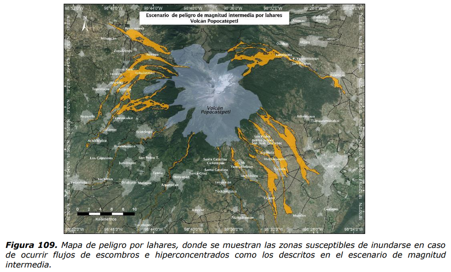
Official, Figure in hazard assessment
Escenario de magnitud intermedia por lahares Volcan Popocatépetl
(Intermediate magnitude scenario due to lahars Popocatépetl Volcano)
Figure 109 in: Martin Del Pozzo, A.L, Alatorre Ibargüengoitia M., Arana Salinas L., Bonasia R., Capra Pedol L., Cassata W., Cordoba G., Cortés Ramos J., Delgado Granados H., Ferrés López M.D., Fonseca Álvarez R., García Reynoso J.A., Gisbert G., Guerrero López D.A., Jaimes Viera M., Macías Vázquez J.L., Nieto Obregon J., Nieto Torres A., Paredes Ruiz P.A., Portocarrero Martínez J., Renne P., Rodríguez Espinosa D.M., Salinas Sánchez S., Siebe Grabach C., & Tellez Ugalde E. (2017). Estudios geológicos y actualización del mapa de peligros del volcán Popocatépetl. Memoria técnica del mapa de peligros del volcán Popocatépetl. Instituto de Geofísica, Universidad Nacional Autónoma de México (UNAM).
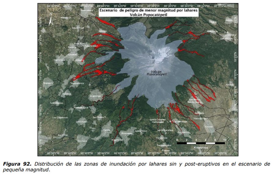
Official, Figure in hazard assessment
Escenario de peligro de menor magnitud por lahares Volcan Popocatépetl
(Hazard scenario of lesser magnitude due to lahars Popocatépetl Volcano)
Figure 92 in: Martin Del Pozzo, A.L, Alatorre Ibargüengoitia M., Arana Salinas L., Bonasia R., Capra Pedol L., Cassata W., Cordoba G., Cortés Ramos J., Delgado Granados H., Ferrés López M.D., Fonseca Álvarez R., García Reynoso J.A., Gisbert G., Guerrero López D.A., Jaimes Viera M., Macías Vázquez J.L., Nieto Obregon J., Nieto Torres A., Paredes Ruiz P.A., Portocarrero Martínez J., Renne P., Rodríguez Espinosa D.M., Salinas Sánchez S., Siebe Grabach C., & Tellez Ugalde E. (2017). Estudios geológicos y actualización del mapa de peligros del volcán Popocatépetl. Memoria técnica del mapa de peligros del volcán Popocatépetl. Instituto de Geofísica, Universidad Nacional Autónoma de México (UNAM).
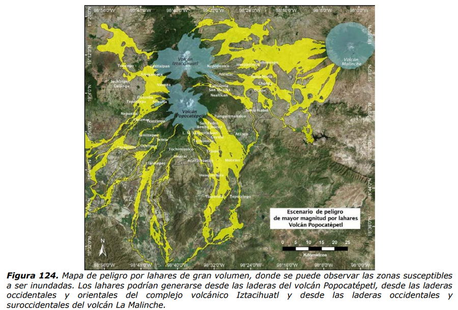
Official, Figure in hazard assessment
Escenario peligro de mayor magnitud por lahares Volcán Popocatépetl
(Hazard scenario of greater magnitude due to lahars Popocatépetl Volcano)
Figure 124 in: Martin Del Pozzo, A.L, Alatorre Ibargüengoitia M., Arana Salinas L., Bonasia R., Capra Pedol L., Cassata W., Cordoba G., Cortés Ramos J., Delgado Granados H., Ferrés López M.D., Fonseca Álvarez R., García Reynoso J.A., Gisbert G., Guerrero López D.A., Jaimes Viera M., Macías Vázquez J.L., Nieto Obregon J., Nieto Torres A., Paredes Ruiz P.A., Portocarrero Martínez J., Renne P., Rodríguez Espinosa D.M., Salinas Sánchez S., Siebe Grabach C., & Tellez Ugalde E. (2017). Estudios geológicos y actualización del mapa de peligros del volcán Popocatépetl. Memoria técnica del mapa de peligros del volcán Popocatépetl. Instituto de Geofísica, Universidad Nacional Autónoma de México (UNAM).

Official, Map sheet or poster
Fuji City Volcano Disaster Prevention Map
Figure 6.3.13 in: Mt. Fuji Hazard Map Review Committee. (2004). Mt. Fuji Hazard Map Review Committee Report. June 2004. https://www.bousai.go.jp/kazan/fuji_map/pdf/report_200406.pdf
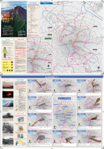
Official, Map sheet or poster
Fujisan Eruption Evacuation Route Map
Fujisan Eruption Evacuation Route Map
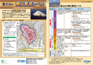
Official, Flyer, brochure, short fact-sheet, or handout
Fujisan Volcanic Alert Levels
Japan Meteorological Agency. (2016). Fujisan Volcanic Alert Levels. Volcano Monitoring and Warning Center, Volcano Division, Earthquake and Volcano Department.