
Advanced Search for Maps
Showing 11-20 of 236
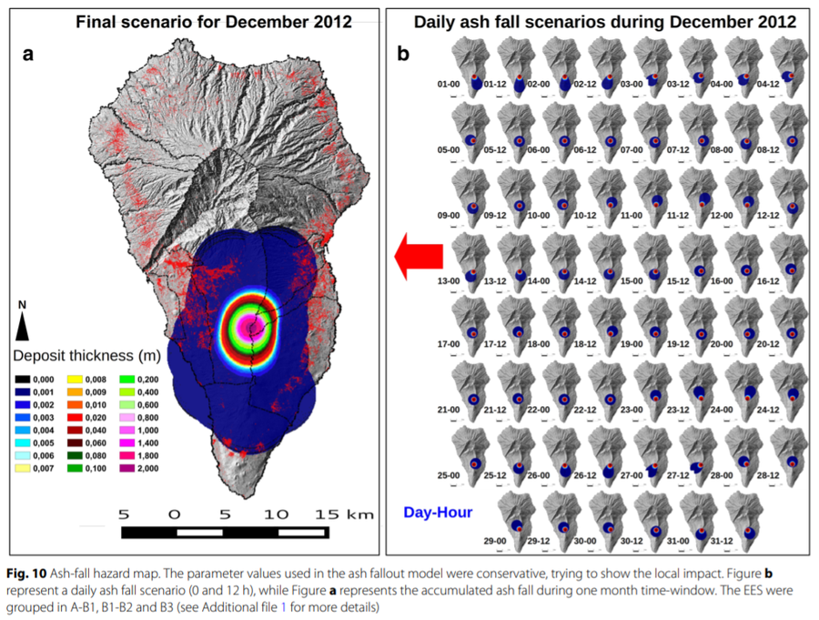
Figure in a journal article
Ash-fall hazard map
Figure 10 in: Marrero, J. M., García, A., Berrocoso, M., Llinares, Á., Rodríguez-Losada, A., & Ortiz, R. (2019). Strategies for the development of volcanic hazard maps in monogenetic volcanic fields: the example of La Palma (Canary Islands). Journal of Applied Volcanology, 8(1), 6. https://doi.org/10.1186/s13617-019-0085-5
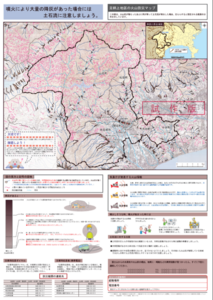
Official, Map sheet or poster
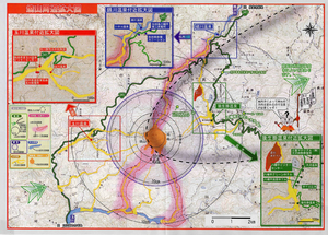
Ashigarakami District Volcanic Disaster Prevention Map
Figure 6.3.14 in: Mt. Fuji Hazard Map Review Committee. (2004). Mt. Fuji Hazard Map Review Committee Report. June 2004. https://www.bousai.go.jp/kazan/fuji_map/pdf/report_200406.pdf
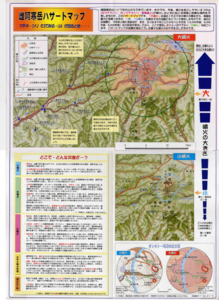
Official, Flyer, brochure, short fact-sheet, or handout
Ashoro Town Meakan-dake Disaster Prevention Map
Ashoro Town. (2000). Ashoro Town Meakan-dake Disaster Prevention Map.
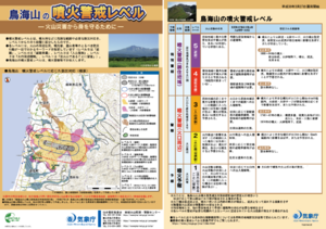
Official, Flyer, brochure, short fact-sheet, or handout
Chokaisan Volcanic Alert Levels
Japan Meteorological Agency. (2018). Chokaisan Volcanic Alert Levels. Volcano Monitoring and Warning Center, Volcano Division, Earthquake and Volcano Department.
Unknown format
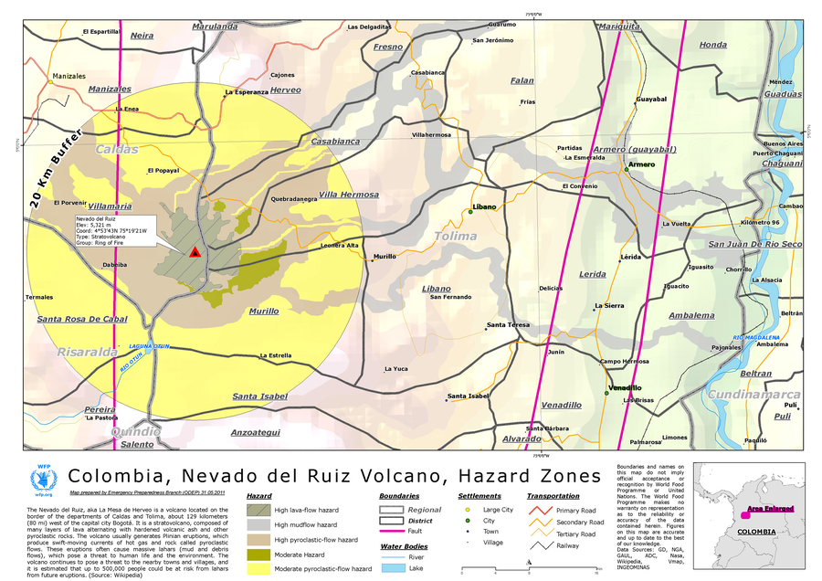
Colombia, Nevado del Ruiz Volcano, Hazard Zones
World Food Programme. (2012). Colombia, Nevado del Ruiz Volcano, Hazard Zones. World Food Programme, Emergency Preparedness Branch (ODEP)
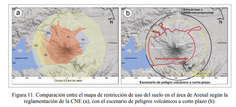
Figure in a journal article
Comparación entre el mapa de restricción de uso del suelo en el área de Arenal según la reglamentación de la CNE, con el escenario de peligros volcánicos a corto plazo.
(Comparison between the land use restriction map in the Arenal area according to CNE regulations, with the short-term volcanic hazard scenario.)
Figure 11 in: Soto, G.J. & Sjöbohm, L. (2005). Sobre el mapeo de los peligros volcánicos del Arenal (Costa Rica) como una herramienta para la planificación del uso del suelo y la mitigación de desastres. Memoria VIII Seminario de Ingeniería Estructural y Sísmica, San José, Costa Rica, Septiembre 2005, 26 p.

Figure in a journal article
Delineation of impact areas for three VBP diameters ejected during the scenario of a hydrothermal eruption at the Hsiaoyiokeng fumarole
Figure 6 in: Nurmawati, A., & Konstantinou, K. I. (2018). Hazard assessment of volcanic ballistic impacts at Mt Chihshin, Tatun Volcano Group, northern Taiwan. Natural hazards, 92(1), p. 77-92. https://doi.org/10.1007/s11069-018-3192-4
Official, Figure in hazard assessment
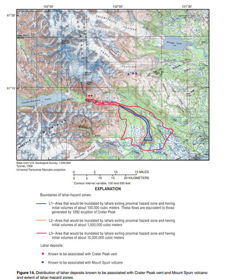
Distribution of lahar deposits known to be associated with Crater Peak vent and Mount Spurr volcano and extent of hazard zones
Figure 14 in: Waythomas, C.F. & Nye, C.J. (2002). Preliminary volcano-hazard assessment for Mount Spurr Volcano, Alaska. U.S. Geological Survey, Open-File Report 2001-482, 40 p., 1 plate. https://doi.org/10.3133/ofr01482
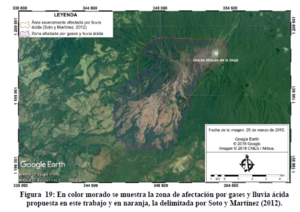
Figure in a thesis or dissertation
En color morado se muestra la zona de afectación por gases y lluvia ácida propuesta en este trabajo y en naranja, la delimitada por Soto y Martínez (2012)
(The zone of affectation by gases and acid rain proposed in this work is shown in purple, and the one delimited by Soto and Martínez (2012) in orange.)
Figure 19 in: Alpízar, Y. (2018). Mapa Preliminar de Peligros Volcánicos para el Volcán Rincón de la Vieja (Costa Rica): Descripción de un Escenario de Afectación por Lahares. Ciudad Universitaria Rodrigo Facio, Costa Rica. 160 p.
Official, Map in a booklet, long fact-sheet, or handbook
Enlarged view around Yakeyama
Akita Prefecture. (2002). Akita-Yakeyama Volcanic Disaster Prevention Map.