
Advanced Search for Maps
Showing 31-40 of 236
Official, Map sheet or poster
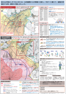
Fujiyoshida City Volcano Disaster Prevention Map
Figure 6.3.11 in: Mt. Fuji Hazard Map Review Committee. (2004). Mt. Fuji Hazard Map Review Committee Report. June 2004. https://www.bousai.go.jp/kazan/fuji_map/pdf/report_200406.pdf
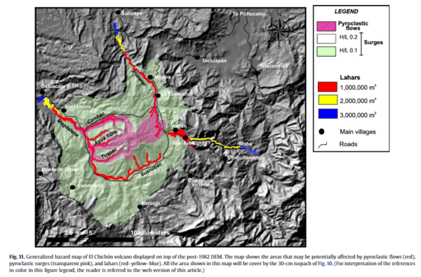
Figure in a journal article
Generalized hazard map of El Chichón volcano displayed on top of the post-1982 DEM
Figure 11 in: Macías, J. L., Capra, L., Arce, J. L., Espíndola, J. M., García-Palomo, A., & Sheridan, M. F. (2008). Hazard map of El Chichón volcano, Chiapas, México: Constraints posed by eruptive history and computer simulations. Journal of Volcanology and Geothermal Research, 175(4), 444-458. https://doi.org/10.1016/j.jvolgeores.2008.02.023
Official, Figure in hazard assessment
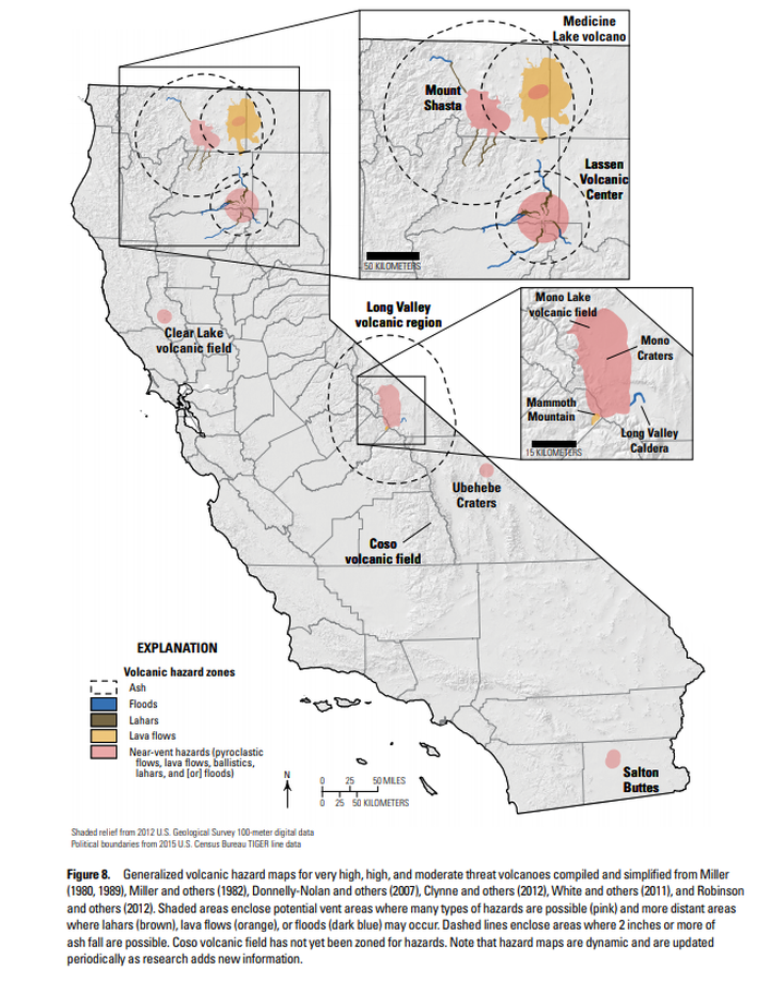
Generalized volcanic hazard maps for very high, high, and moderate threat volcanoes compiled and simplified from Miller (1980, 1989), Miller and others (1982), Donnelly-Nolan and others (2007), Clynne and others (2012), White and others (2011), and Robinson and others (2012)
Figure 8 in: Mangan, M., Ball, J., Wood, N., Jones, J.L., Peters, J., Abdollahian, N., Dinitz, L., Blankenheim, S., Fenton, J., & Pridmore, C. (2019). California’s exposure to volcanic hazards. U.S. Geological Survey Scientific Investigations Report 2018–5159, v. 1.1, 49 p. https://doi.org/10.3133/sir20185159
Official, Insert/poster-size map with accompanying report
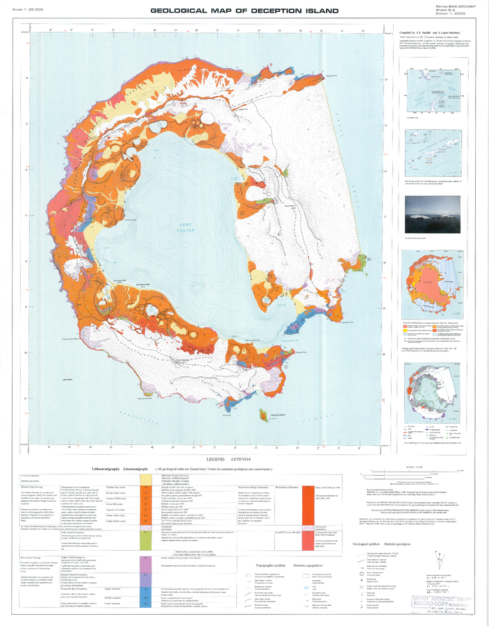
Geologic Map of Deception Island
Sheet 6-A in: Smellie, J.L., López-Martínez, J., Headland, R.K., Hernández-Cifuentes, F., Maestro, A., Millar, I.L., Rey, J., Serrano, E., Somoza, L., & Thomson, J.W. (2002). Geology and geomorphology of Deception Island. Cambridge, British Antarctic Survey, 77 p. (BAS Geomap Series, Sheets 6A and 6B).
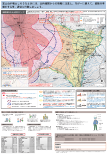
Official, Map sheet or poster
Gotemba Volcano Disaster Prevention Map
Figure 6.3.12 in: Mt. Fuji Hazard Map Review Committee. (2004). Mt. Fuji Hazard Map Review Committee Report. June 2004. https://www.bousai.go.jp/kazan/fuji_map/pdf/report_200406.pdf
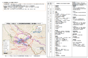
Official, Figure in hazard assessment
Hakkodasan (Odake Crater) Eruption Warning Area Map (Eruption Warning Level 4-5)
Figure 3-4 in: Hakkodasan Volcanic Hazards Mitigation Committee. (2019). Hakkoda volcano evacuation plan. Aomori Prefecture, Aomori City, Towada City, Kuroishi City, and Hirakawa City.
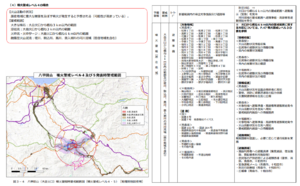
Official, Figure in hazard assessment
Hakkodasan (Odake crater) eruption warning regulation map (volcanic alert level 3)
Figure 3-3 in: Hakkodasan Volcanic Hazards Mitigation Committee. (2019). Hakkoda volcano evacuation plan. Aomori Prefecture, Aomori City, Towada City, Kuroishi City, and Hirakawa City.
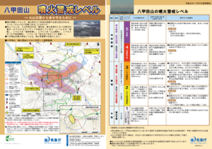
Official, Flyer, brochure, short fact-sheet, or handout
Hakkodasan Volcanic Alert Levels
Japan Meteorological Agency. (2019). Hakkodasan Volcanic Alert Levels. Volcano Monitoring and Warning Center, Volcano Division, Earthquake and Volcano Department.
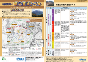
Official, Flyer, brochure, short fact-sheet, or handout
Hakoneyama Volcanic Alert Levels
Japan Meteorological Agency. (2017). Hakoneyama Volcanic Alert Levels. Volcano Monitoring and Warning Center, Volcano Division, Earthquake and Volcano Department.
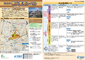
Official, Flyer, brochure, short fact-sheet, or handout
Hakusan Volcanic Alert Levels
Japan Meteorological Agency. (2016). Hakusan Volcanic Alert Levels. Volcano Monitoring and Warning Center, Volcano Division, Earthquake and Volcano Department.