
Advanced Search for Maps
Showing 61-70 of 236
Official, Insert/poster-size map with accompanying report
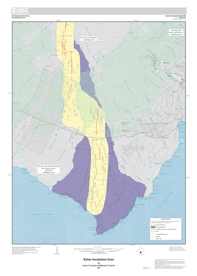
Kalae Inundation Zone
Sheet 6 in: Trusdell, F.A. & Zoeller, M.H. (2017). Lava inundation zone maps for Mauna Loa, Island of Hawaiʻi, Hawaii. U.S. Geological Survey, Scientific Investigations Map 3387, 12 p., 10 sheets. https://doi.org/10.3133/sim3387
Official, Insert/poster-size map with accompanying report
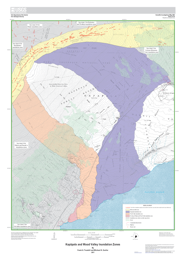
Kapāpala and Wood Valley Inundation Zones
Sheet 3 in: Trusdell, F.A. & Zoeller, M.H. (2017). Lava inundation zone maps for Mauna Loa, Island of Hawaiʻi, Hawaii. U.S. Geological Survey, Scientific Investigations Map 3387, 12 p., 10 sheets. https://doi.org/10.3133/sim3387
Official, Sign or billboard
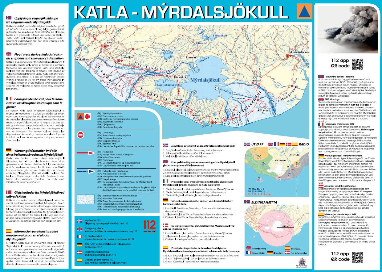
Katla – Mýrdalsjökull
Almannavarnir. (2017). Katla – Mýrdalsjökull.
Official, Insert/poster-size map with accompanying report
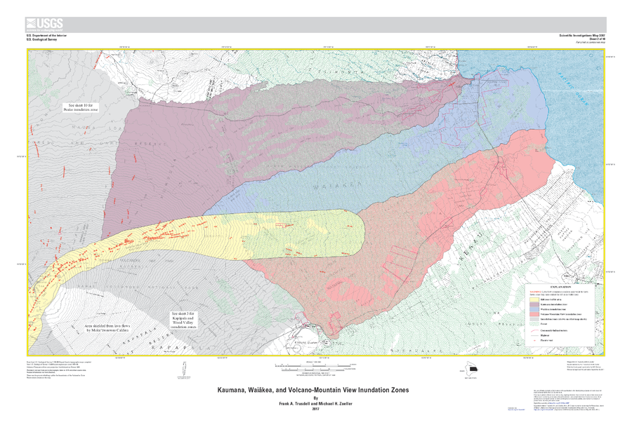
Kaumana, Waiākea, and Volcano-Mountain View Inundation Zones
Sheet 2 in: Trusdell, F.A. & Zoeller, M.H. (2017). Lava inundation zone maps for Mauna Loa, Island of Hawaiʻi, Hawaii. U.S. Geological Survey, Scientific Investigations Map 3387, 12 p., 10 sheets. https://doi.org/10.3133/sim3387
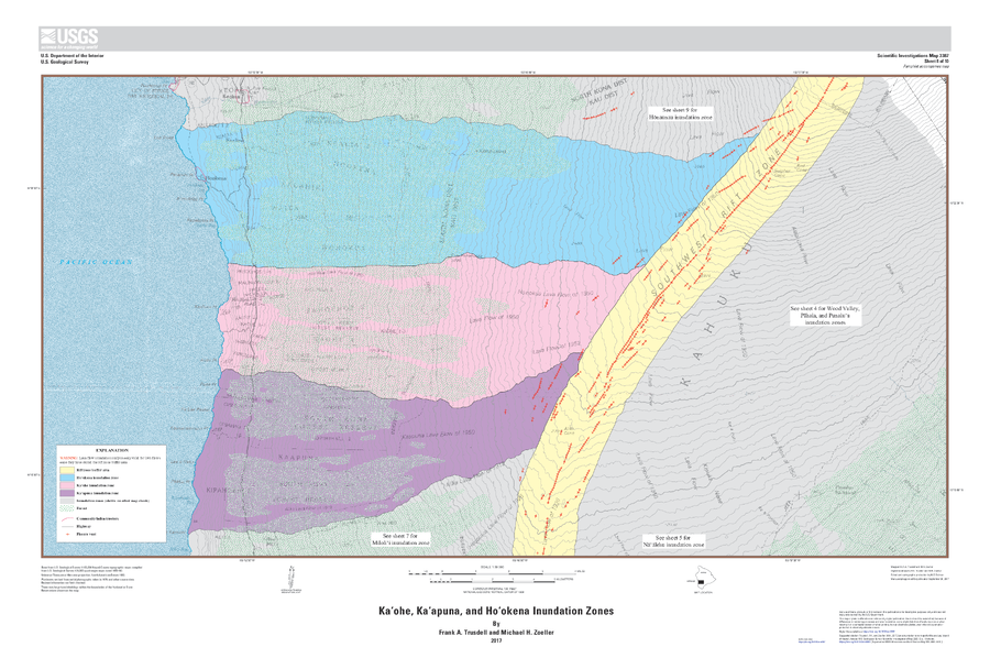
Official, Insert/poster-size map with accompanying report
Kaʻohe, Kaʻapuna, and Hoʻokena Inundation Zones
Sheet 8 in: Trusdell, F.A. & Zoeller, M.H. (2017). Lava inundation zone maps for Mauna Loa, Island of Hawaiʻi, Hawaii. U.S. Geological Survey, Scientific Investigations Map 3387, 12 p., 10 sheets. https://doi.org/10.3133/sim3387
Official, Map sheet or poster
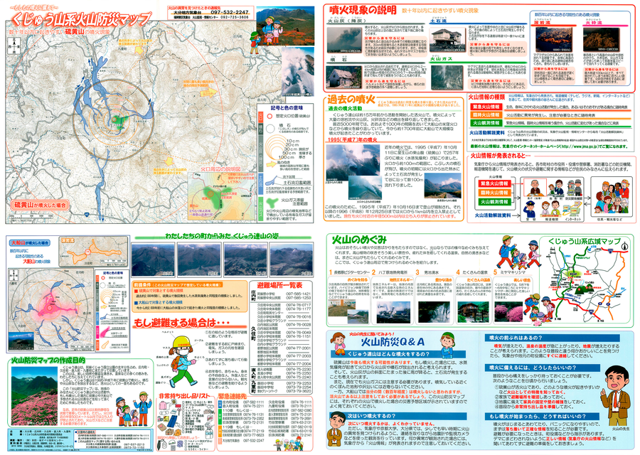
Kuju Mountain Volcano Disaster Prevention Map
Oita Prefecture, Yufu City, Taketa City, Kokonoe Town. (2004). Kuju Mountain Volcano Disaster Prevention Map.
Official, Flyer, brochure, short fact-sheet, or handout
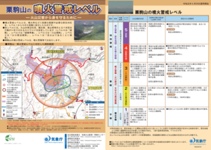
Kurikomayama Volcanic Alert Levels
Japan Meteorological Agency. (2019). Kurikomayama Volcanic Alert Levels. Volcano Monitoring and Warning Center, Volcano Division, Earthquake and Volcano Department.
Official (foreign agency), Insert/poster-size map with accompanying report
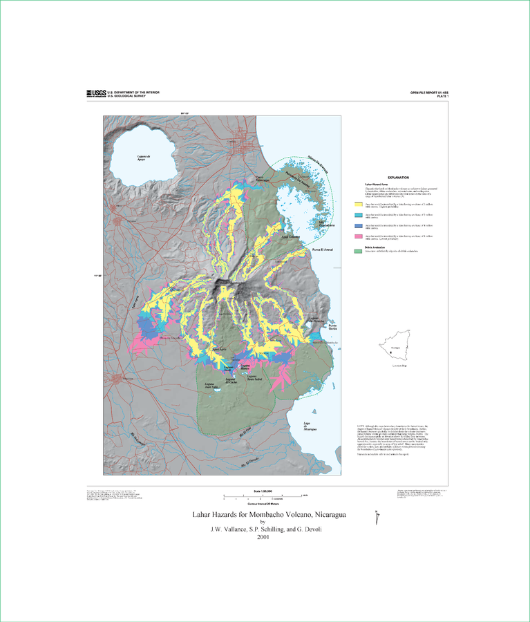
Lahar Hazards for Mombacho Volcano, Nicaragua
Plate 1 (Color) in: Vallance, J.W., Schilling, S.P., Devoli, G. (2001). Lahar Hazards at Mombacho Volcano, Nicaragua. U.S. Geological Survey, Open-File Report 01-455, 16 p., 1 plate. https://doi.org/10.3133/ofr01455
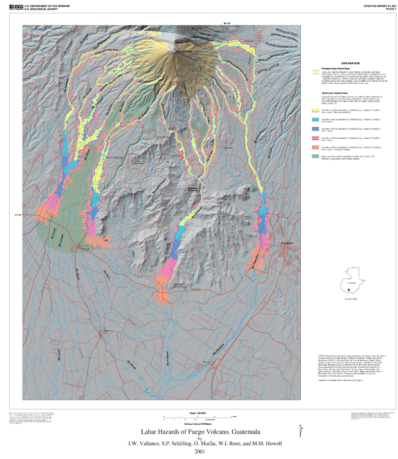
Official (foreign agency), Insert/poster-size map with accompanying report
Lahar Hazards of Fuego Volcano, Guatemala
Plate 1 (Color) in: Vallance, J.W., Schilling, S.P., Matías, O., Rose, W.I. & Howell, M.M. (2001). Volcano Hazards at Fuego and Acatenango, Guatemala. U.S. Geological Survey, Open-File Report 01-431. https://doi.org/10.3133/ofr01431
Official, Map in a booklet, long fact-sheet, or handbook
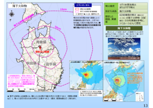
Large-scale eruption (assuming billions of cubic meters of magma eruption) pyroclastic fall
Page 13 in: Towada Volcanic Hazards Mitigation Committee. (2018). Towada Volcano Hazard Expected Impact Area Map. Omori Prefecture Disaster Risk Management Division, Akita Prefecture Disaster Prevention Division, Nagano City General Affairs Division, Kosaka Town General Affairs Division.