
Advanced Search for Maps
Showing 41-50 of 236
Official, Insert/poster-size map with accompanying report
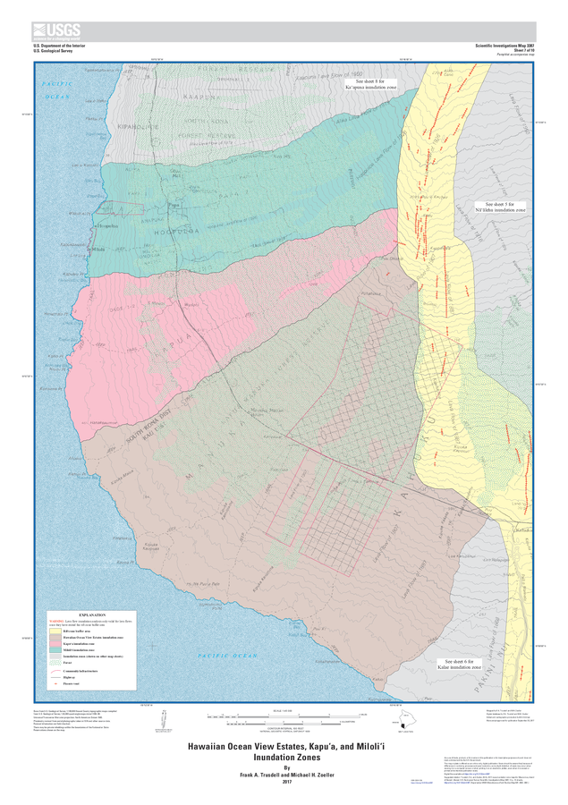
Hawaiian Ocean View Estates, Kapuʻa, and Miloliʻi Inundation Zones
Sheet 7 in: Trusdell, F.A. & Zoeller, M.H. (2017). Lava inundation zone maps for Mauna Loa, Island of Hawaiʻi, Hawaii. U.S. Geological Survey, Scientific Investigations Map 3387, 12 p., 10 sheets. https://doi.org/10.3133/sim3387
Official, Map sheet or poster
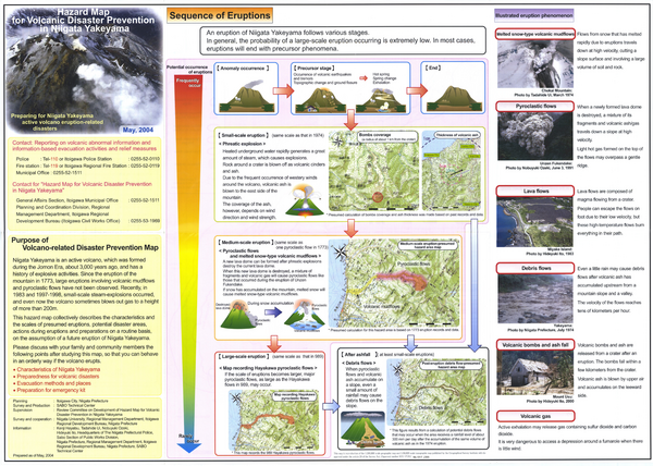
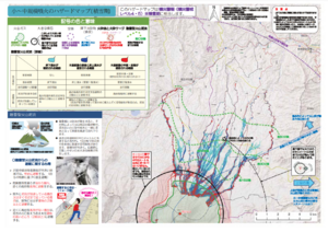
Hazard Map for Volcanic Disaster Prevention in Niigata Yakekama
Niigata Prefecture & Itoigawa City. (2004). Hazard Map for Volcanic Disaster Prevention in Niigata Yakayama.
Official, Map in a booklet, long fact-sheet, or handbook
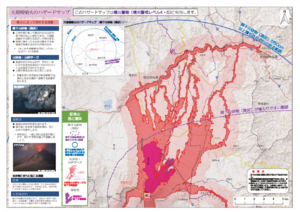
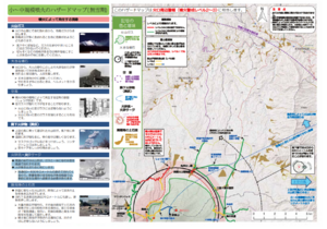
Hazard map of large-scale eruption
Asamayama Volcanic Disaster Prevention Committee. (2019). Asamayama Volcanic Disaster Prevention Map. Tsumagoi Village.
Official, Map in a booklet, long fact-sheet, or handbook
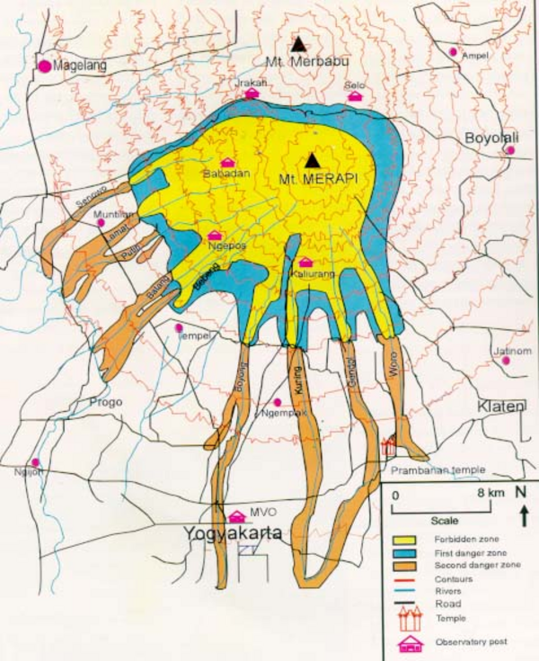
Hazard Map of Merapi
Purbawinata, M. A., Ratdomopurbo, A., Sinulingga, I. K., Sumarti, S., & Suharno, I. (1996). Merapi volcano – guide book. Volcanological Survey of Indonesia (VSI), Bandung. (Reprinted in: Gerstenecker, C., Läufer, G., Steineck, D., Tiede, C., & Wrobel, B. (2005). Validation of digital elevation models around Merapi Volcano, Java, Indonesia. Natural Hazards and Earth System Sciences, 5(6), 863-876. https://doi.org/10.5194/nhess-5-863-2005)
Official, Map in a booklet, long fact-sheet, or handbook
Hazard map of small to medium-scale eruptions (snow season)
Asamayama Volcanic Disaster Prevention Committee. (2019). Asamayama Volcanic Disaster Prevention Map. Tsumagoi Village.
Official, Map in a booklet, long fact-sheet, or handbook
Hazard map of small to medium-scale eruptions (snowless period)
Asamayama Volcanic Disaster Prevention Committee. (2019). Asamayama Volcanic Disaster Prevention Map. Tsumagoi Village.
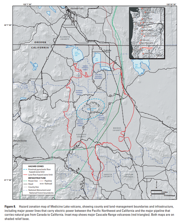
Official, Figure in hazard assessment
Hazard zonation map of Medicine Lake volcano, showing county and land-management boundaries and infrastructure
Figure 8 in: Donnelly-Nolan, J.M., Nathenson, M., Champion, D.E., Ramsey, D.W., Lowenstern, J.B., & Ewert, J.W. (2007). Volcano Hazards Assessment for Medicine Lake Volcano, Northern California. Scientitic Investigations Report 2007-5174-A. Plate 1. https://doi.org/10.3133/sir20075174A
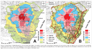
Figure in a journal article
Hazard zones 1 (highest hazard) to 6 (lowest hazard, but highest vulnerability) based on the volcanological parameters of past eruptions, high vent density areas, and present day morphology
Figure 6 in: Behncke, B., Neri, M., & Nagay, A. (2005). Lava flow hazard at Mount Etna (Italy): new data from a GIS-based study. In: Manga, M. and Ventura, G. Kinematics and Dynamics of Lava Flows. Geological Society of America, Special Paper 396. https://doi.org/10.1130/0-8137-2396-5.189
Official, Unknown format
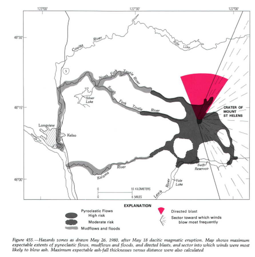
Hazard zones as drawn May 26, 1980, after May 18 dacitic magmatic eruption.
Figure 455 in: Miller, C.D., Mullineaux, D.R. & Crandell, D.R. (1981). Hazards assessments at Mount St. Helens. In: Lipman, P. W. & Mullineaux, D. R. (Eds.) The 1980 eruptions of Mount St. Helens, Washington. U.S. Geological Survey, Professional Paper 1250, p. 789-802. https://doi.org/10.3133/pp1250
Official (foreign agency), Figure on website
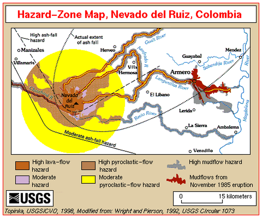
Hazard-Zone Map, Nevado del Ruiz, Colombia
Topinka, L. (1998). Hazard-Zone Map, Nevado del Ruiz, Colombia. U.S. Geological Survey. http://vulcan.wr.usgs.gov/Imgs/Gif/Ruiz/Maps/map_ruiz_hazard_zones.gif (Modified from: Wright et al. 1992)