
Advanced Search for Maps
Showing 91-98 of 98
Official, Map in a booklet, long fact-sheet, or handbook
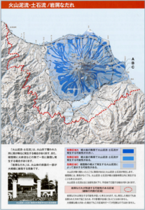
Volcanic eruption hazard area prediction map: Volcanic mudlfow, debris flow/debris avalanche
Page 12 in: Volcano Disaster Management Councils of Mt. Komagatake. (2010). Volcanic disaster prevention handbook of Mt.Komagatake
Official, Figure on website
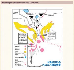
Volcanic gas fumarolic areas near Owakudani
Hakone-machi Town. (2004). Volcanic gas fumarolic area near Owakudani. Hakone Volcano Disaster Prevention Map. https://www.town.hakone.kanagawa.jp/index.cfm/10,1212,46,167,html
Official, Figure on website
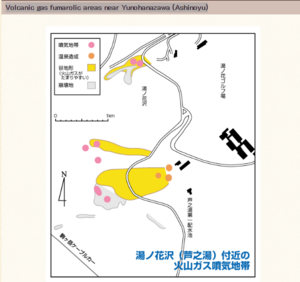
Volcanic gas fumarolic areas near Yunohanazawa (Ashinoyu)
Hakone-machi Town. (2004). Volcanic gas fumarolic zone near Yunohanazawa (Ashinoyu). Hakone Volcano Disaster Prevention Map. https://www.town.hakone.kanagawa.jp/index.cfm/10,1213,46,167,html
Official, Map in an information statement
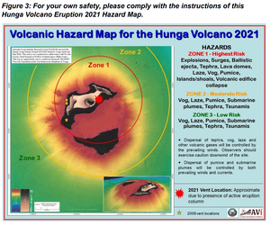
Volcanic Hazard Map for the Hunga Volcano 2021
Figure 3 in: Tonga Geological Services. (2022). Volcanic Hazard Map for the Hunga Volcano 2021. Facebook post 2022-01-03. https://www.facebook.com/tongageologicalservice/posts/228114139479654.
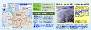
Official, Map in a booklet, long fact-sheet, or handbook
Volcanic mud flow
Page 15 in: Towada Volcanic Hazards Mitigation Committee. (2018). Towada Volcano Hazard Expected Impact Area Map. Omori Prefecture Disaster Risk Management Division, Akita Prefecture Disaster Prevention Division, Nagano City General Affairs Division, Kosaka Town General Affairs Division.

Official, Map in a booklet, long fact-sheet, or handbook
Volcanic-Ash Hazard Area Map
Page 14 in: Crandell, D.R. & Nichols, D.R. (1989). Volcanic hazards at Mount Shasta, California. U.S. Geological Survey, General Information Product, 22 p. https://doi.org/10.3133/70039409
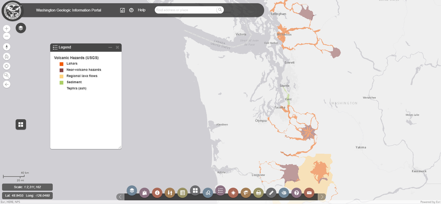
Official, Interactive web-based map
Washington Geologic Information Portal - Volcanic Hazards (USGS)
Washington Department of Natural Resources. Geologic Information Portal.
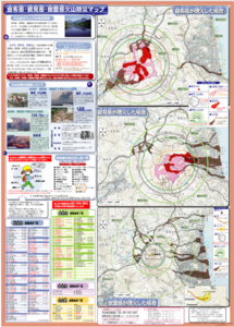
Official, Map sheet or poster
Yufudake/Tsurumidake/Garandake Volcano Disaster Prevention Map
Beppu City, Yufu City, Oita Prefecture, Usa City, & Hiji Town Survey. (2006). Yufudake/Tsurumidake/Garandake Volcano Disaster Prevention Map.