
Advanced Search for Maps
Showing 51-60 of 98
Official, Figure on website
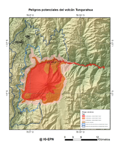
Peligros potenciales del Volcán Tungurahua
(Potential hazards of Tungurahua volcano)
Instituto Geofísico de la Escuela Politecnica Nacional (IG-EPN). (2022). Peligros potenciales del volcán Tungurahua. Volcán Tungurahua. https://www.igepn.edu.ec/amenaza-volcanica/mapa-amenaza-tungurahua

Official, Flyer, brochure, short fact-sheet, or handout
Popocatépetl - Avalanchas
(Popocatépetl - Avalanches)
Map 5 in: Instituto de Geofísica Universidad Nacional Autónoma de México (IG-UNAM), Centro Nacional de Prevención de Desastres (CENAPRED), Secretaría de Gobernación (SEGOB) (2016). Popocatépetl. Gobierno de México. (Simplified from: Martin Del Pozzo et al. 2016)
Official, Flyer, brochure, short fact-sheet, or handout
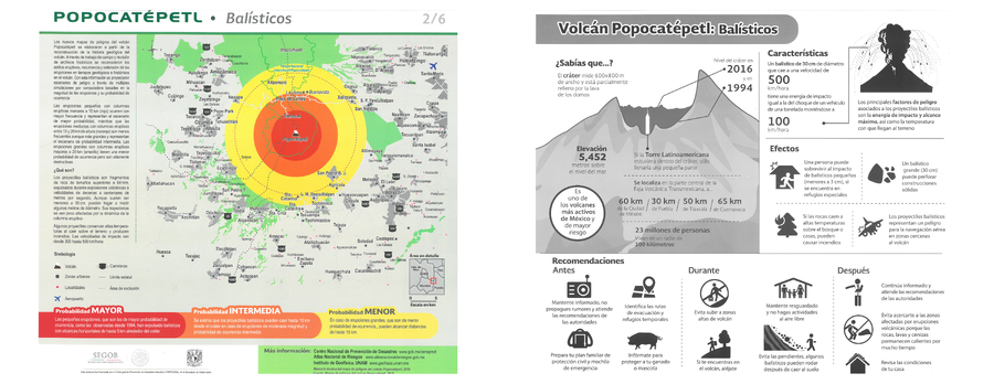
Popocatépetl - Balísticos
(Popocatépetl - Ballistics)
Map 2 in: Instituto de Geofísica Universidad Nacional Autónoma de México (IG-UNAM), Centro Nacional de Prevención de Desastres (CENAPRED), Secretaría de Gobernación (SEGOB). (2016). Popocatépetl - Balísticos. Gobierno de México. (Simplified from: Martin Del Pozzo et al. 2016)
Official, Flyer, brochure, short fact-sheet, or handout
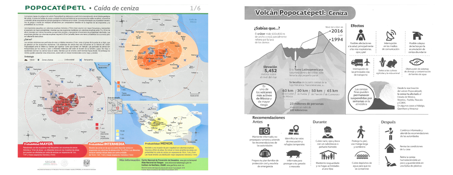
Popocatépetl - Caída de ceniza
(Popocatépetl - Ash fall)
Map 1 in: Instituto de Geofísica Universidad Nacional Autónoma de México (IG-UNAM), Centro Nacional de Prevención de Desastres (CENAPRED), Secretaría de Gobernación (SEGOB). (2016). Popocatépetl - Caída de ceniza. Gobierno de México. (Simplified from: Martin Del Pozzo et al. 2016)
Official, Flyer, brochure, short fact-sheet, or handout
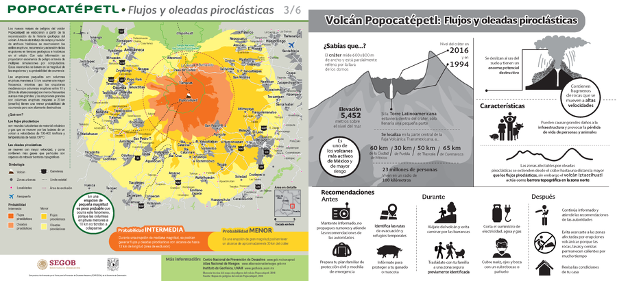
Popocatépetl - Flujos y oleadas piroclásticas
(Popocatépetl - Pyroclastic flows and surges)
Map 3 in: Instituto de Geofísica Universidad Nacional Autónoma de México (IG-UNAM), Centro Nacional de Prevención de Desastres (CENAPRED), Secretaría de Gobernación (SEGOB). (2016). Popocatépetl - Flujos y oleadas piroclásticas. Gobierno de México. (Simplified from: Martin Del Pozzo et al. 2016)
Official, Flyer, brochure, short fact-sheet, or handout
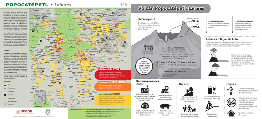
Popocatépetl - Lahares
(Popocatépetl - Lahars)
Map 4 in: Instituto de Geofísica Universidad Nacional Autónoma de México (IG-UNAM), Centro Nacional de Prevención de Desastres (CENAPRED), Secretaría de Gobernación (SEGOB). (2016). Popocatépetl - Lahares. Gobierno de México. (Simplified from: Martin Del Pozzo et al. 2016)

Official, Flyer, brochure, short fact-sheet, or handout
Popocatépetl - Lavas
(Popocatépetl - Lavas)
Map 6 in: Instituto de Geofísica Universidad Nacional Autónoma de México (IG-UNAM), Centro Nacional de Prevención de Desastres (CENAPRED), Secretaría de Gobernación (SEGOB). (2016). Popocatépetl - Lavas. Gobierno de México. (Simplified from: Martin Del Pozzo et al. 2016)
Official, Map in a booklet, long fact-sheet, or handbook
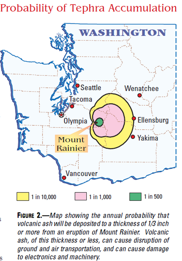
Probability of Tephra Accumulation
Figure 2 in: Driedger, C.L. & Scott, K.M. (2002). Mount Rainier: learning to live with volcanic risk. U.S. Geological Survey, Fact Sheet 034-02, 4 p. https://doi.org/10.3133/fs03402

Official, Map in a booklet, long fact-sheet, or handbook
Pyroclastic Flow and Lateral Blast Hazard Map
Page 15 in: Crandell, D.R. & Nichols, D.R. (1989). Volcanic hazards at Mount Shasta, California. U.S. Geological Survey, General Information Product, 22 p. https://doi.org/10.3133/70039409
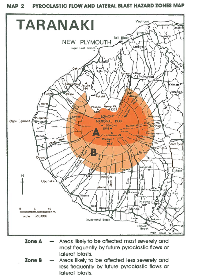
Official, Figure in hazard assessment
Pyroclastic Flow and Lateral Blast Hazard Zones Map
Map 2, Page 17 in: Neall, V.E. & Alloway, B.V. (1993). Volcanic hazards at Egmont volcano. Volcanic Hazards Working Group of the Scientific Advisory Committee, Ministry of Civil Defence. Volcanic Hazards Information Series, Number One, 2nd ed. 31 p.