
Advanced Search for Maps
Showing 61-70 of 98
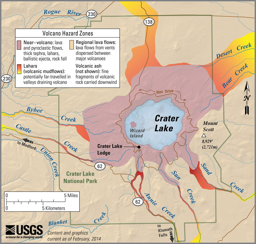
Official, Figure on website
Simplified volcano hazards map of Crater Lake, Oregon
Bacon, C.R., Mastin, L.G., Scott, K., Nathenson, M., Driedger, C.L., Scott, W.E., Iverson, R.M., Ramsey, D.W., & Faust, L.M. (2014). Simplified volcano hazards map of Crater Lake, Oregon. U.S. Geological Survey. Crater Lake, OR Simplified Hazards Map. https://www.usgs.gov/media/images/crater-lake-or-simplified-hazards-map (Modified from: U.S. Geological Survey, Open-File Report 97-487)
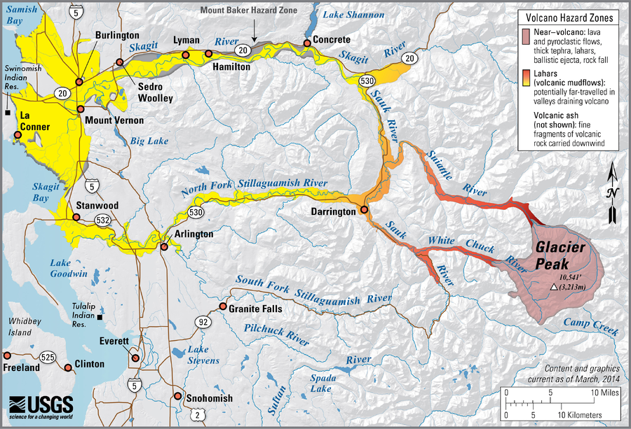
Official, Figure on website
Simplified volcano hazards map of Glacier Peak, Washington
Waitt, R., Mastin, L.G., Beget, J.E., Driedger, C.L., Scott, W.E., Iverson, R.M., Ramsey, D.W., & Faust, L.M. (2014). Simplified volcano hazards map of Glacier Peak, Washington. U.S. Geological Survey. Glacier Peak, WA Simplified Hazards Map. https://www.usgs.gov/media/images/glacier-peak-wa-simplified-hazards-map (Modified from: U.S. Geological Survey, Open-File Report 95-499)

Official, Figure on website
Simplified volcano hazards map of Lassen Volcanic Center, California
Clynne, M.A., Robinson, J.E., Nathenson, M., Muffler, L.J.P., Driedger, C.L., Scott, W.E., Iverson, R.M., & Faust, L.M. (2014). Simplified volcano hazards map of Lassen Volcanic Center, California. U.S. Geological Survey. Lassen Volcanic Center, CA Simplified Hazards Map. https://www.usgs.gov/media/images/lassen-volcanic-center-ca-simplified-hazards-map (Modified from: U.S. Geological Survey, Scientific Investigations Report 2012-5176-A)

Official, Figure on website
Simplified volcano hazards map of Medicine Lake, California
Donnelly-Nolan, J.M., Nathenson, M., Champion, D.E., Ramsey, D.W., Lowenstern, J.B., Ewert, J.W., Driedger, C.L., Scott, W.E., Iverson, R.M., & Faust, L.M. (2014). Simplified volcano hazards map of Medicine Lake, California. U.S. Geological Survey. Medicine Lake, CA simplified hazards map. https://www.usgs.gov/media/images/medicine-lake-ca-simplified-hazards-map (Modified from: U.S. Geological Survey, Scientific Investigations Report 2007-5174-A)
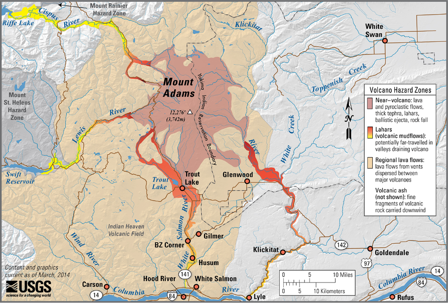
Official, Figure on website
Simplified volcano hazards map of Mount Adams, Washington
Scott, W.E., Iverson, R., Vallance, J.W., Hildreth, W., Driedger, C.L., Ramsey, D.W., & Faust, L.M. (2014). Simplified volcano hazards map of Mount Adams, Washington. U.S. Geological Survey. Mount Adams, WA Simplified Hazards Map. https://www.usgs.gov/media/images/mount-adams-wa-simplified-hazards-map (Modified from: U.S. Geological Survey, Open-File Report 95-492)

Official, Figure on website
Simplified volcano hazards map of Mount Baker, Washington
Gardner, C., Scott, K., Miller, C.D., Myers, B., Hildreth, W., Pringle, P.T., Driedger, C.L., Scott, W.E., Iverson, R.M., Ramsey, D.W., & Faust, L.M. (2014). Simplified volcano hazards map of Mount Baker, Washington. U.S. Geological Survey. Mount Baker, WA Simplified Hazards Map. https://www.usgs.gov/media/images/mount-baker-wa-simplified-hazards-map (Modified from: U.S. Geological Survey, Open-File Report 95-498)
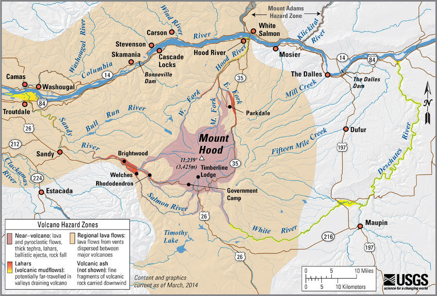
Official, Figure on website
Simplified volcano hazards map of Mount Hood, Oregon
Scott, W.E., Pierson, T.C., Schilling, S.P., Costa, J.E., Gardner, C.A., Vallance, J.W., Major, J.J., Driedger, C.L., Iverson, R.M., Ramsey, D.W., & Faust, L.M. (2014). Simplified volcano hazards map of Mount Hood, Oregon. U.S. Geological Survey. Mount Hood, OR Simplified Hazards Map. https://www.usgs.gov/media/images/mount-hood-or-simplified-hazards-map (Modified from: U.S. Geological Survey, Open-File Report 97-89)
Official, Figure on website
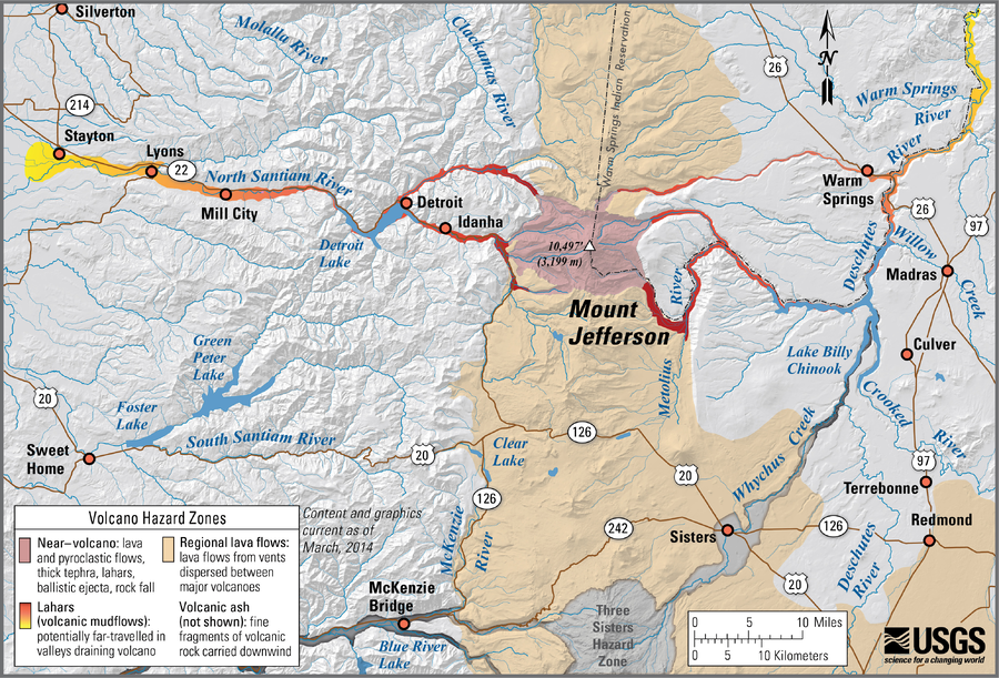
Simplified volcano hazards map of Mount Jefferson, Oregon
Walder, J.S., Gardner, C., Conrey, R.M., Fisher, B.J., Schilling, S.P., Driedger, C.L., Scott, W.E., Iverson, R.M., Ramsey, D.W., & Faust, L.M. (2014). Simplified volcano hazards map of Mount Jefferson, Oregon. U.S. Geological Survey. Mount Jefferson, OR Simplified Hazards Map. https://www.usgs.gov/media/images/mount-jefferson-or-simplified-hazards-map (Modified from: U.S. Geological Survey, Open-File Report 99-24)
Official, Figure on website
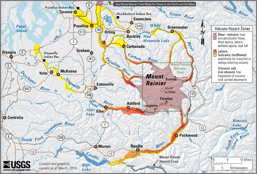
Simplified volcano hazards map of Mount Rainier, Washington
Hoblitt, R.P., Walder, J.S., Driedger, C.L., Scott, K.M., Pringle, P.T., Vallance, J.W., Scott, W.E., Iverson, R.M., Ramsey, D.W., & Faust, L.M. (2014). Simplified volcano hazards map of Mount Rainier, Washington. U.S. Geological Survey. Mount Rainier, WA Simplified Hazards Map. https://www.usgs.gov/media/images/mount-rainier-wa-simplified-hazards-map (Modified from: U.S. Geological Survey, Open-File Report 98-428)
Official, Figure on website
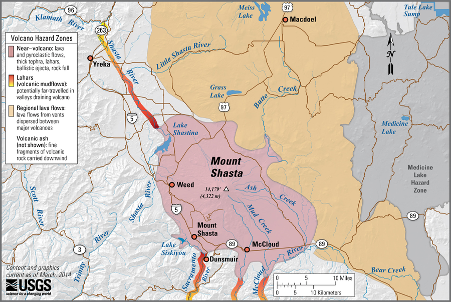
Simplified volcano hazards map of Mount Shasta, California
Miller, C. D., Driedger, C.L., Scott, W.E., Iverson, R.M., Ramsey, D.W., & Faust, L.M. (2014). Simplified volcano hazards map of Mount Shasta, California. U.S. Geological Survey. Mount Shasta, CA Simplified Hazards Map. https://www.usgs.gov/media/images/mount-shasta-ca-simplified-hazards-map (Modified from: U.S. Geological Survey, Bulletin 1503)