
Advanced Search for Maps
Showing 431-440 of 2217
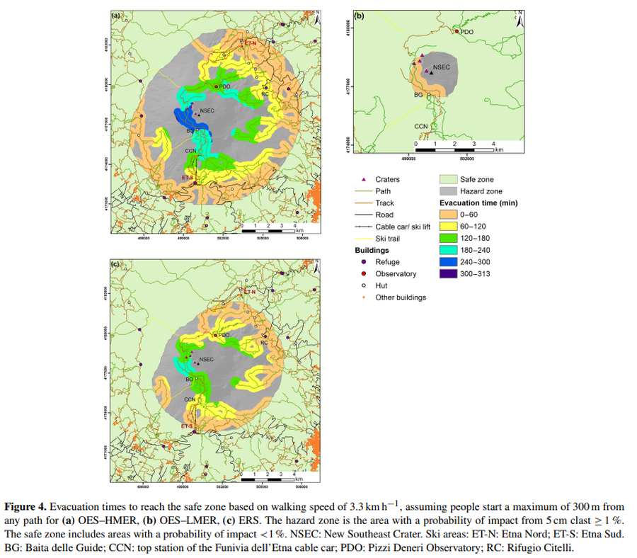
Figure in a journal article
Evacuation times to reach the safe zone based on walking speed of 3.3 km h^−1
Figure 4 in: Osman, S., Rossi, E., Bonadonna, C., Frischknecht, C., Andronico, D., Cioni, R., & Scollo, S. (2019). Exposure-based risk assessment and emergency management associated with the fallout of large clasts at Mount Etna. Natural Hazards and Earth System Sciences, 19(3), 589-610. https://doi.org/10.5194/nhess-19-589-2019
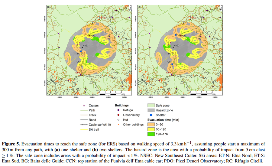
Figure in a journal article
Evacuation times to reach the safe zone based on walking speed of 3.3 km h^−1, assuming people start a maximum of 300 m from any path, with (a) one shelter and (b) two shelters
Figure 5 in: Osman, S., Rossi, E., Bonadonna, C., Frischknecht, C., Andronico, D., Cioni, R., & Scollo, S. (2019). Exposure-based risk assessment and emergency management associated with the fallout of large clasts at Mount Etna. Natural Hazards and Earth System Sciences, 19(3), 589-610. https://doi.org/10.5194/nhess-19-589-2019
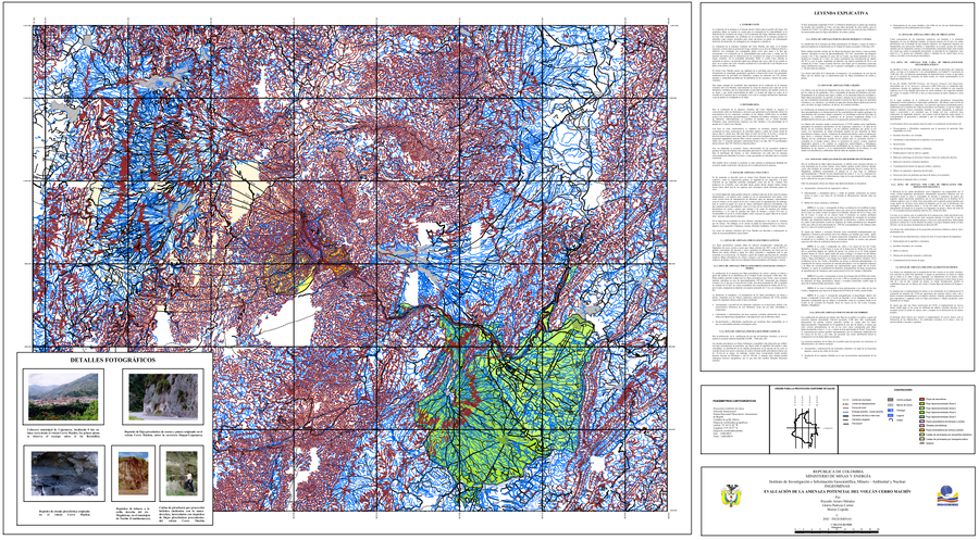
Official, Map sheet or poster
Evaluación de la Amenaza Potencial del Volcán Cerro Machín
(Assessment of Potential Hazards of Cerro Machín Volcano)
Méndez, R.A., Cortés, G.P., & Cepeda, H. (2002). Evaluación de la Amenaza Potencial del Volcán Cerro Machín. Instituto de Investigación e Información Geocientífica, Minero - Ambiental y Nuclear (INGEOMINAS). mapa escala 1:150,213. Bogotá with accompanying text: INGEOMINAS (Instituto de Investigación e Información Geocientífica, Minero, Ambiental Y Nuclear). (2003) Memoria explicativa del Mapa de Amenaza Volcánica del Cerro Machín. Bogotá.
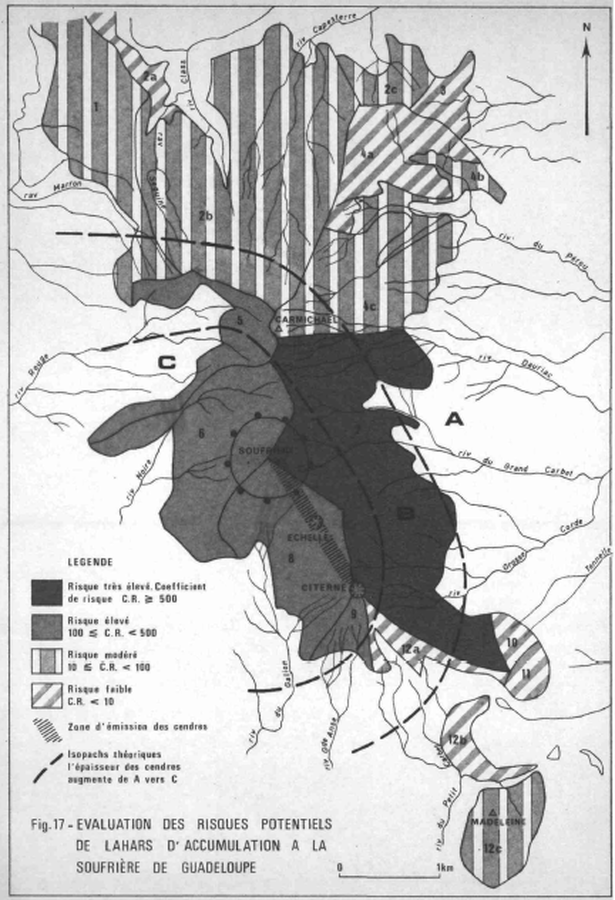
Official, Figure in hazard assessment
Evaluation des Risques Potentiels de Lahars d'Accumulation a la Soufrière de Guadeloupe
(Assessment of the Potential Risks of Lahars of Accumulation at the Soufriere of Guadeloupe)
Figure 17 in: Westercamp, D. (1977) Levés géologiques, évaluation et zonation des risques volcaniques à la Soufrière de Guadeloupe F. W. I. (Rapport de mission) Mai-Juin 1977. Délégation Générale a la Recherche Scientifique et Technique. 77 Ant 29
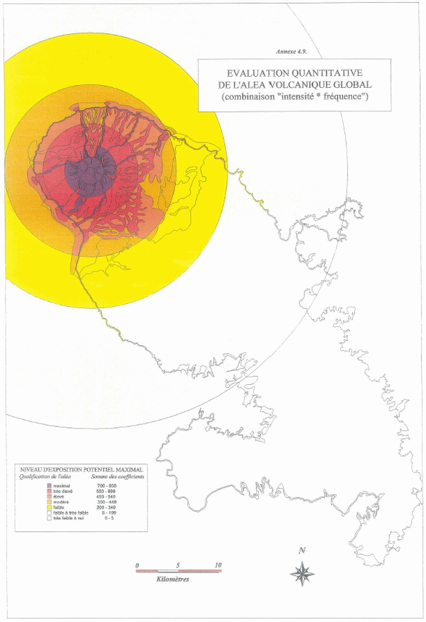
Official, Figure in hazard assessment
Evaluation Quantitative De L'Aléa Volcanique Global (combinaison "intensite * fréquence)
(Quantitative Assessment of the Global Volcanic Hazard (combination "intensity * frequency))
Annex 4.9 in: Stieltjes, L. & Mirgon, C. (1998). Approche méthodologique de la vulnérabilité aux phénomènes volcaniques. Test d’application sur les réseaux de la Martinique. Rapport de synthese. Rapport Bureau de Recherches Géologiques et Minières (BRGM), Marseille, R 40098. http://infoterre.brgm.fr/rapports/RR-40098-FR.pdf
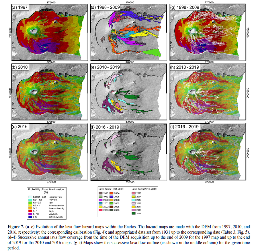
Figure in a journal article
Evolution of the lava flow hazard maps within the Enclos
Figure 7 in: Chevrel, M. O., Favalli, M., Villeneuve, N., Harris, A. J., Fornaciai, A., Richter, N., Derrien, A., Di Muro, A., & Peltier, A. (2021). Lava flow hazard map of Piton de la Fournaise volcano. Natural Hazards and Earth System Sciences, 21(8), 2355-2377. https://doi.org/10.5194/nhess-21-2355-2021, 2021
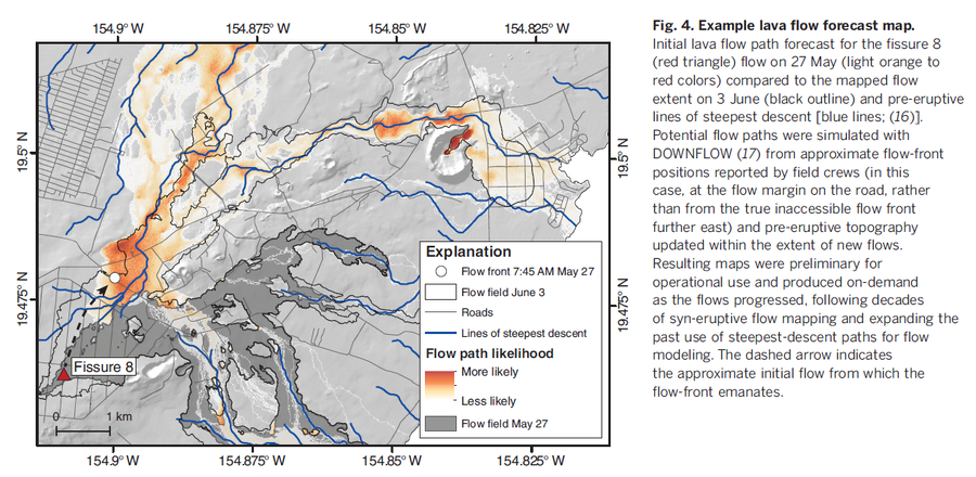
Official, Figure in a journal article
Example lava flow forecast map
Figure 4 in: Neal, C. A., Brantley, S. R., Antolik, L., Babb, J. L., Burgess, M., Calles, K., ... & Damby, D. (2019). The 2018 rift eruption and summit collapse of Kīlauea Volcano. Science, 363(6425), 367-374.
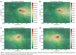
Figure in a journal article
Example of uncertainty on hazard maps for tephra load exceeding 100 kg/m² for the dry (10th and 90th percentiles of the posterior pdf) and rainy (10th and 90th percentiles of the posterior pdf) seasons
Figure 12 in: Sandri, L., Thouret, J. C., Constantinescu, R., Biass, S., & Tonini, R. (2014). Long-term multi-hazard assessment for El Misti volcano (Peru). Bulletin of volcanology, 76(2), 771. https://doi.org/10.1007/s00445-013-0771-9
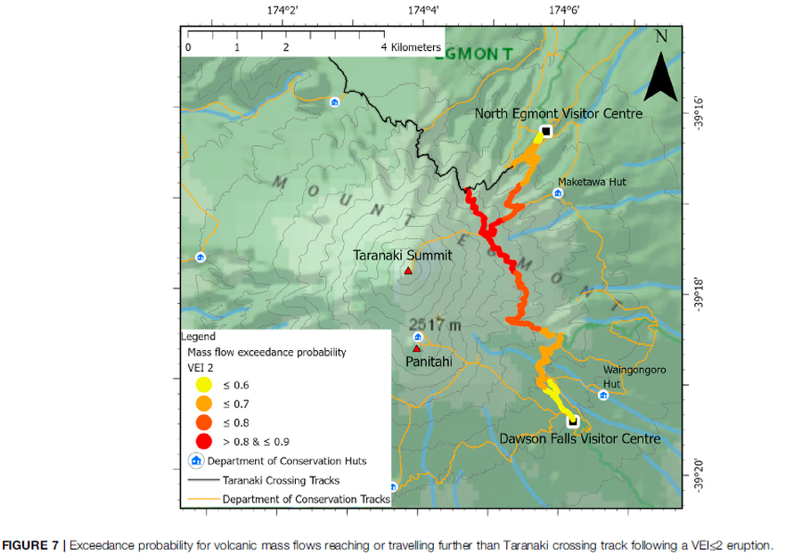
Figure in a journal article
Exceedance probability for volcanic mass flows reaching or travelling further than Taranaki crossing track following a VEI≤2 eruption
Figure 7 in: Mead, S., Procter, J., Bebbington, M., & Rodriguez-Gomez, C. (2022). Probabilistic Volcanic Hazard Assessment for National Park Infrastructure Proximal to Taranaki Volcano (New Zealand). Frontiers in Earth Science, 435. https://doi.org/10.3389/feart.2022.832531
Official, Figure in a journal article
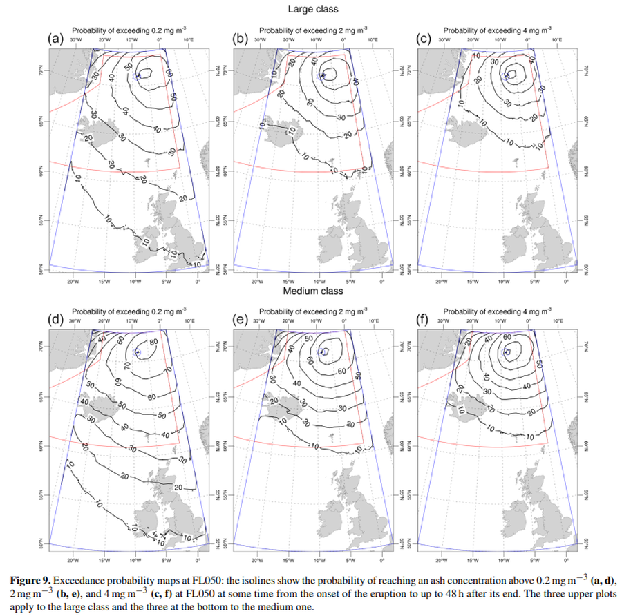
Exceedance probability maps at FL050
Figure 9 in: Titos, M., Martínez Montesinos, B., Barsotti, S., Sandri, L., Folch, A., Mingari, L., Macedonio, G. & Costa, A. (2022). Long-term hazard assessment of explosive eruptions at Jan Mayen (Norway) and implications for air traffic in the North Atlantic. Natural Hazards and Earth System Sciences, 22(1), 139-163. https://doi.org/10.5194/nhess-22-139-2022