
Advanced Search for Maps
Showing 781-790 of 2217
Official, Insert/poster-size map with accompanying report
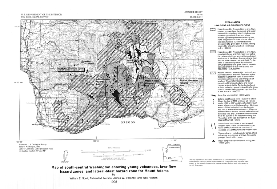
Map of south-central Washington showing young volcanoes, lava-flow hazard zones, and lateral-blast hazard zone for Mount Adams
Plate 1 in: Scott, W.E., Iverson, R.M., Vallance, J.W., & Hildreth, W. (1995). Volcano Hazards in the Mount Adams Region, Washington. U.S. Geological Survey, Open-File Report 95-492. https://doi.org/10.3133/ofr95492
Official, Figure on website
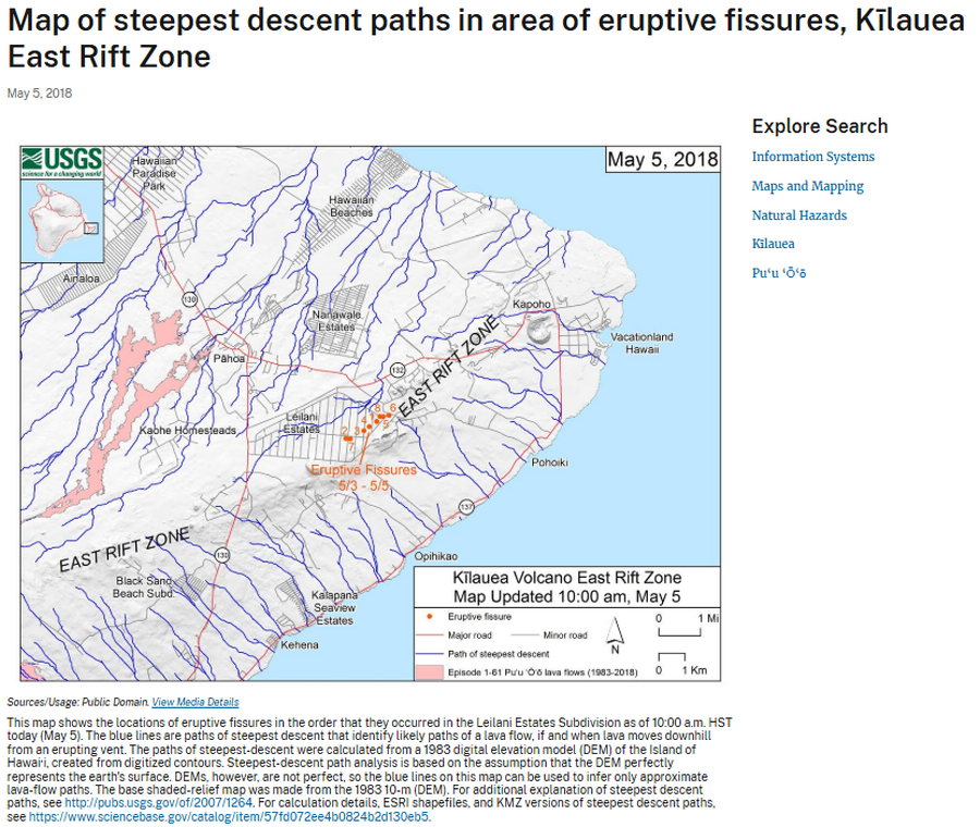
Map of steepest descent paths in area of eruptive fissures, Kīlauea East Rift Zone
U.S. Geological Survey (USGS). (2018). Map of steepest descent paths in area of eruptive fissures, Kīlauea East Rift Zone. U.S. Geological Survey. https://www.usgs.gov/maps/map-steepest-descent-paths-area-eruptive-fissures-kilauea-east-rift-zone
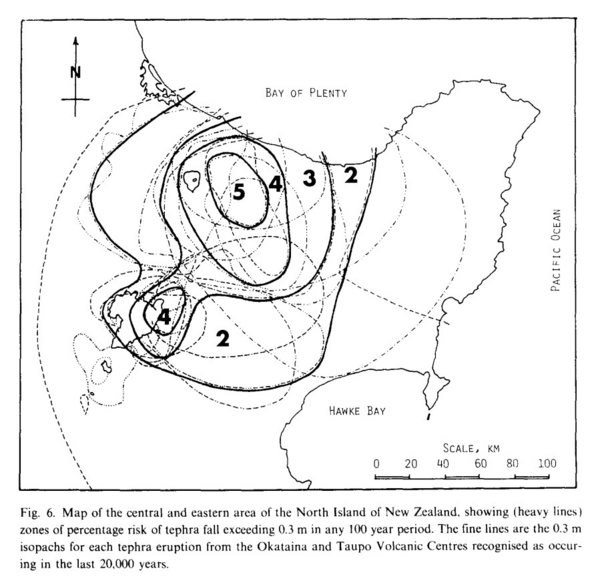
Figure in a journal article
Map of the central and eastern area of the North Island of New Zealand, showing (heavy lines) zones of percentage risk of tephra fall exceeding 0.3 m in any 100 year period
Figure 6 in: Dibble, R.R., Nairn, I.A., & Neall, V.E. (1985). Volcanic hazards of North Island, New Zealand--Overview. Journal of Geodynamics, 3, p. 369-396. https://doi.org/10.1016/0264-3707(85)90043-2
Official, Map in a booklet, long fact-sheet, or handbook
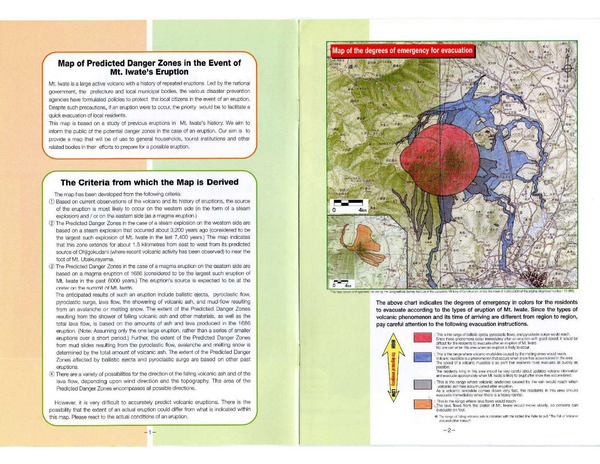
Map of the degrees of emergency for evacuation
The Counter-measures Investigation Committee on Volcanic Disasters at Mt. Iwate. (1998). Mt. Iwate Volcanic Disaster Prevention Handbook. 8 p.
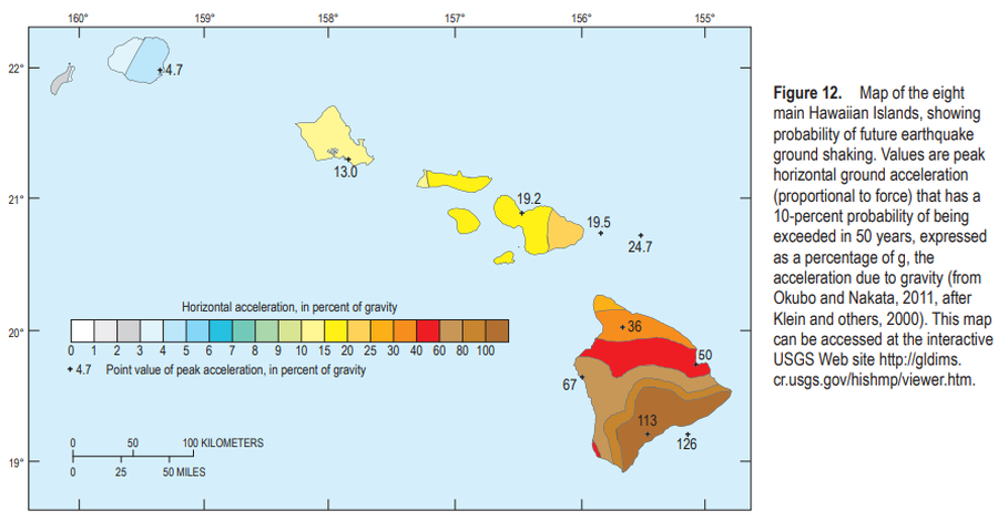
Official, Figure in a journal article
Map of the eight main Hawaiian Islands, showing probability of future earthquake ground shaking
Figure 12 in: Kauahikaua, J.P. & Tilling, R.I. (2014). Natural hazards and risk reduction in Hawai‘i. In: Poland, M.P., Takahashi, T.J., & Landowski, C.M. (eds.) Characteristics of Hawaiian Volcanoes. US Geological Survey Professional Paper 1801, p. 397-427. https://doi.org/10.3133/pp180110
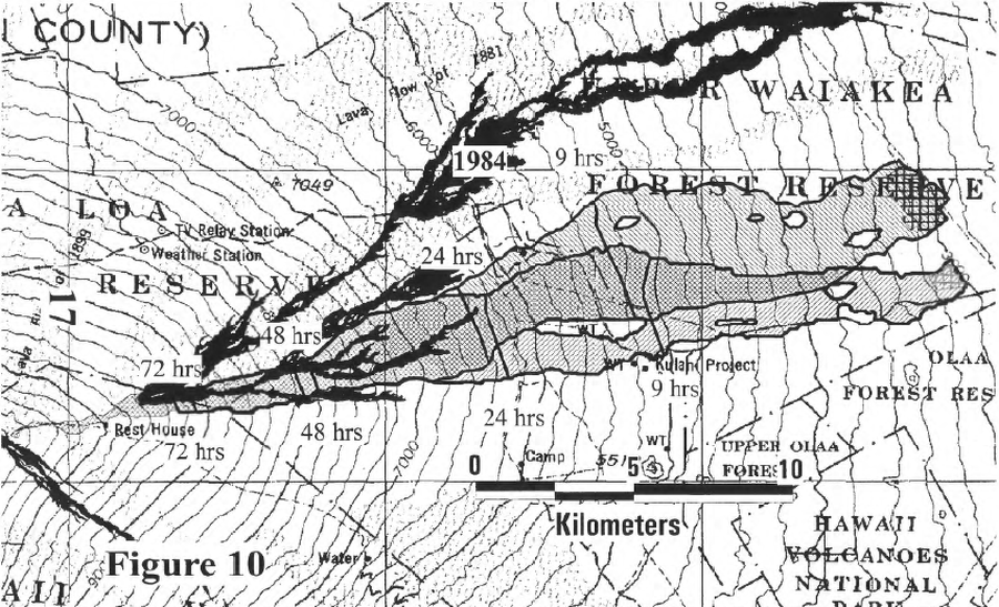
Official, Figure in hazard assessment
Map of the lavashed for future prison Site B and Site C showing the 9-, 24-, 48-, and 72-hour warning lines
Figure 10 in: Kauahikaua, J. P., Trusdell, F. A., & Heliker, C. C. (1998). The probability of lava inundation at the proposed and existing Kulani Prison Sites. US Geological Survey, Open-File Report 98-794. 21 p. https://doi.org/10.3133/ofr98794
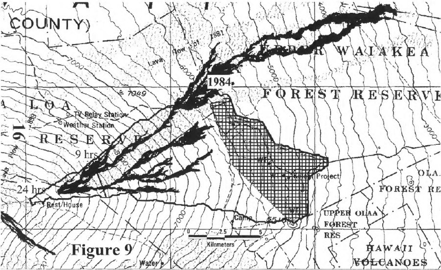
Official, Figure in hazard assessment
Map of the lavashed for the existing prison site showing the 9- and 24-hour warning lines
Figure 9 in: Kauahikaua, J. P., Trusdell, F. A., & Heliker, C. C. (1998). The probability of lava inundation at the proposed and existing Kulani Prison Sites. US Geological Survey, Open-File Report 98-794. 21 p. https://doi.org/10.3133/ofr98794

Official, Figure in hazard assessment
Map of the middle east rift zone of Kilauea Volcano showing the hazard zonation of the former Campbell Estate property at Kahauale‘a, the three geothermal subzones, and the subsequent coverage by lavas from the current eruption
Figure 3 in: Kauahikaua, J. P., Moore, R. B., & Delaney, P. (1994). Volcanic activity and ground deformation hazard analysis for the Hawaii geothermal project environmental impact statement. US Geological Survey, Open File Report 94-553. 44 p. https://doi.org/10.3133/ofr94553
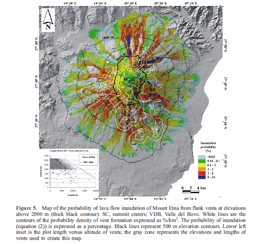
Figure in a journal article
Map of the probability of lava flow inundation of Mount Etna from flank vents at elevations above 2000 m
Figure 5 in: Favalli, M., Mazzarini, F., Pareschi, M. T., & Boschi, E. (2009). Topographic control on lava flow paths at Mount Etna, Italy: implications for hazard assessment. Journal of Geophysical Research: Earth Surface, 114(F1). https://doi.org/10.1029/2007JF000918

Figure in a journal article
Map of the probability of lava flow inundation of Mount Etna from flank vents at elevations above 2000 m calculated assuming a uniform probability of vent opening.
Figure 7 in: Favalli, M., Mazzarini, F., Pareschi, M. T., & Boschi, E. (2009). Topographic control on lava flow paths at Mount Etna, Italy: implications for hazard assessment. Journal of Geophysical Research: Earth Surface, 114(F1). https://doi.org/10.1029/2007JF000918