
Advanced Search for Maps
Showing 771-780 of 2217

Official, Figure in hazard assessment
Map of natural gas pipelines and substations in northern California
Figure 20 in: Mangan, M., Ball, J., Wood, N., Jones, J.L., Peters, J., Abdollahian, N., Dinitz, L., Blankenheim, S., Fenton, J., & Pridmore, C. (2019). California’s exposure to volcanic hazards. U.S. Geological Survey Scientific Investigations Report 2018–5159, v. 1.1, 49 p. https://doi.org/10.3133/sir20185159
Official, Figure in a journal article
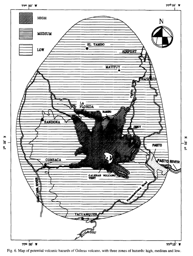
Map of potencial volcanic hazards of Galeras volcano, with three zones of hazards: high, medium and low
Figure 6 in: Artunduaga, A.D.H., & Jiménez, G.P.C. (1997). Third version of the hazard map of Galeras Volcano, Colombia. Journal of Volcanology and Geothermal research, 77(1-4), p. 89-100. https://doi.org/10.1016/S0377-0273(96)00088-1
Official, Figure in hazard assessment
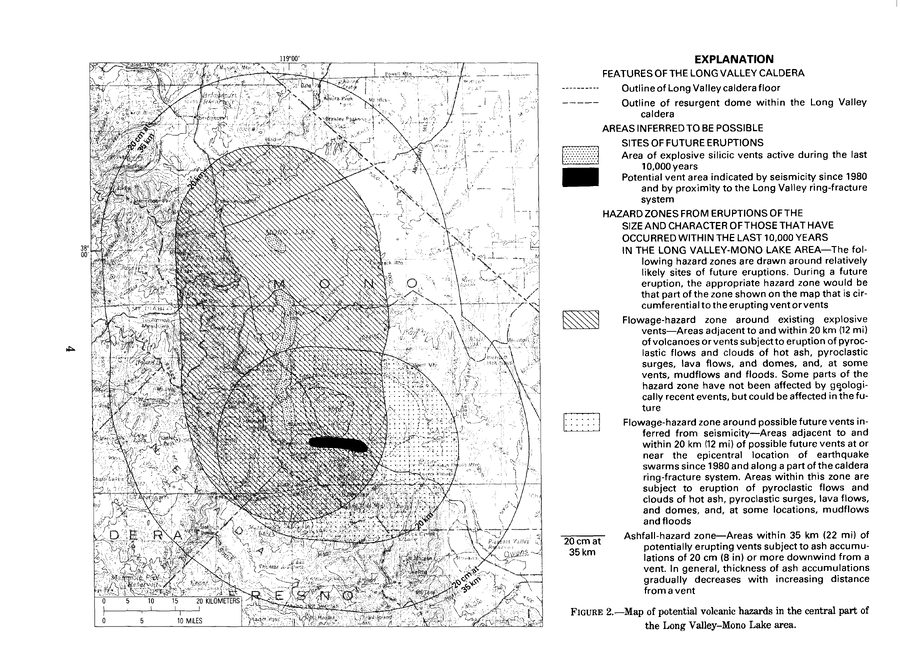
Map of potential volcanic hazards in the central part of the Long Valley-Mono Lake area
Figure 2 in: Miller, C.D., Mullineaux, D.R., Crandell, D.R. & Bailey, R.A. (1982). Potential hazards from future volcanic eruptions in the Long Valley-Mono Lake area, east-central California and southwest Nevada; a preliminary assessment. U.S. Geological Survey, Circular 877, 10 p. https://doi.org/10.3133/cir877
Official, Figure in a journal article
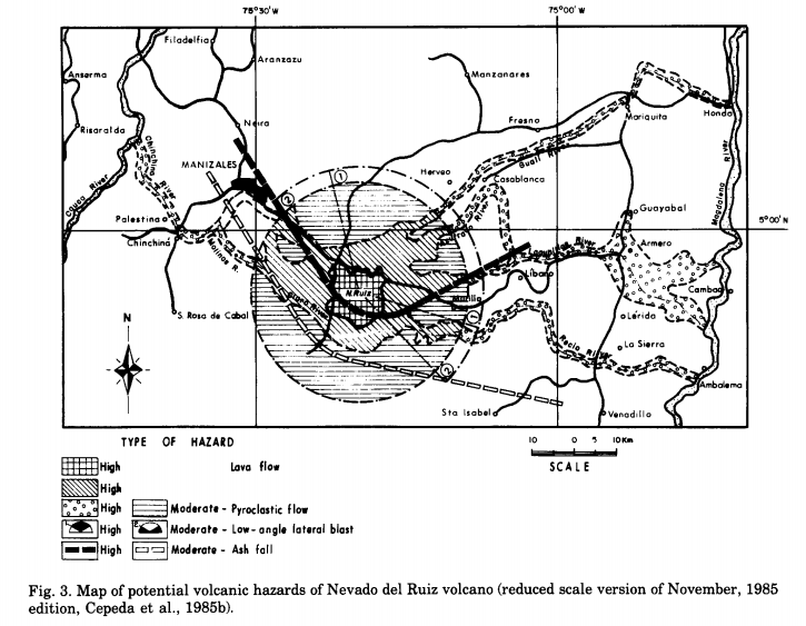
Map of potential volcanic hazards of Nevado del Ruiz volcano (reduced scale version of November, 1985 edition)
Figure 3 in: Parra, E. & Cepeda, H. (1990). Volcanic hazard maps of the Nevado del Ruiz volcano, Colombia. Journal of Volcanology and Geothermal Research, 42, p. 177-127. https://doi.org/10.1016/0377-0273(90)90073-O (Modified from: Cepeda et al. 1985)
Official, Figure in a journal article
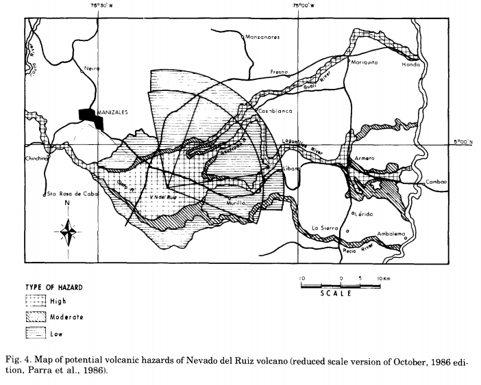
Map of potential volcanic hazards of Nevado del Ruiz volcano (reduced scale version of October, 1986 edition)
Figure 4 in: Parra, E. & Cepeda, H. (1990). Volcanic hazard maps of the Nevado del Ruiz volcano, Colombia. Journal of Volcanology and Geothermal Research, 42, p. 177-127. https://doi.org/10.1016/0377-0273(90)90073-O (Modified from: Parra et al. 1986)
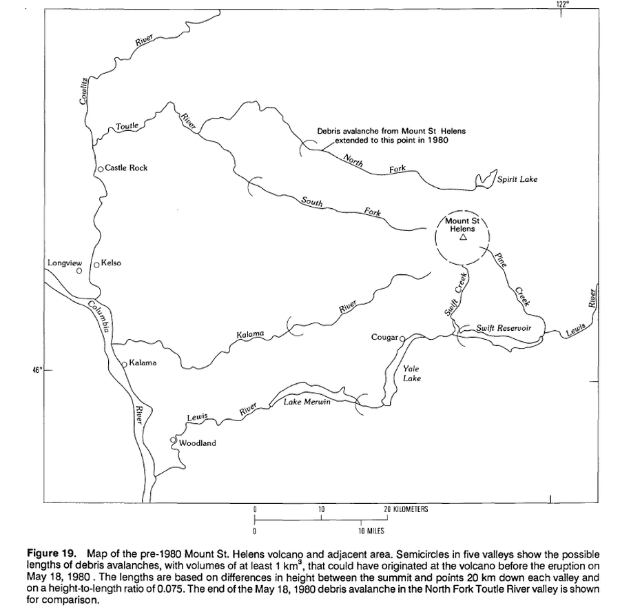
Official, Figure in hazard assessment
Map of pre-1980 Mount St. Helens volcano and adjacent area.
Figure 19 in: Crandell, D.R. (1989). Gigantic debris avalanche of Pleistocene age from ancestral Mount Shasta Volcano, California, and debris-avalanche hazard zonation. U.S. Geological Survey, Bulletin 1861, 32 p. https://doi.org/10.3133/b1861
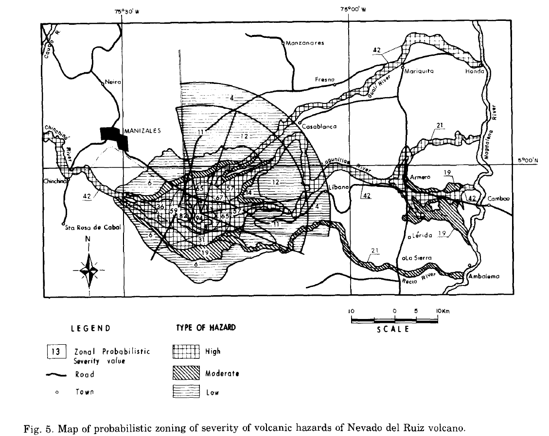
Official, Figure in a journal article
Map of probabilistic zoning of severity of volcanic hazards of Nevado del Ruiz volcano
Figure 5 in: Parra, E. & Cepeda, H. (1990). Volcanic hazard maps of the Nevado del Ruiz volcano, Colombia. Journal of Volcanology and Geothermal Research, 42, p. 177-127. https://doi.org/10.1016/0377-0273(90)90073-O
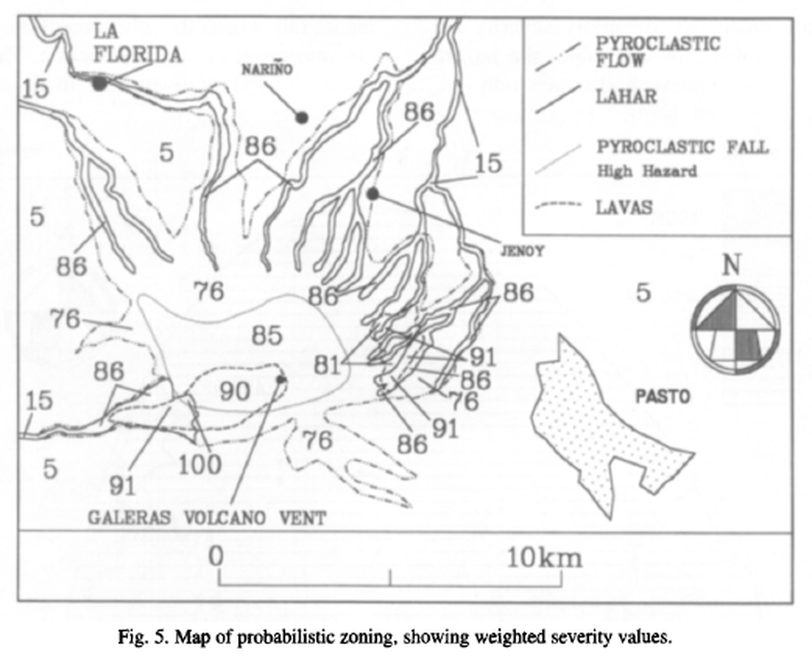
Official, Figure in a journal article
Map of probabilistic zoning, showing weighted severity values
Figure 5 in: Artunduaga, A.D.H., & Jiménez, G.P.C. (1997). Third version of the hazard map of Galeras Volcano, Colombia. Journal of Volcanology and Geothermal research, 77(1-4), p. 89-100. https://doi.org/10.1016/S0377-0273(96)00088-1
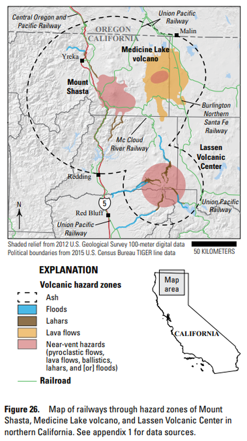
Official, Figure in hazard assessment
Map of railways through hazard zones of Mount Shasta, Medicine Lake volcano, and Lassen Volcanic Center in northern California
Figure 26 in: Mangan, M., Ball, J., Wood, N., Jones, J.L., Peters, J., Abdollahian, N., Dinitz, L., Blankenheim, S., Fenton, J., & Pridmore, C. (2019). California’s exposure to volcanic hazards. U.S. Geological Survey Scientific Investigations Report 2018–5159, v. 1.1, 49 p. https://doi.org/10.3133/sir20185159
Official, Figure in hazard assessment
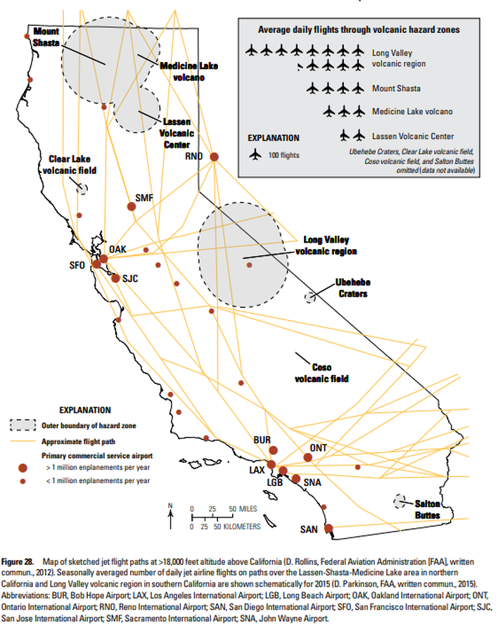
Map of sketched jet flight paths at >18,000 feet altitude above California
Figure 28 in: Mangan, M., Ball, J., Wood, N., Jones, J.L., Peters, J., Abdollahian, N., Dinitz, L., Blankenheim, S., Fenton, J., & Pridmore, C. (2019). California’s exposure to volcanic hazards. U.S. Geological Survey Scientific Investigations Report 2018–5159, v. 1.1, 49 p. https://doi.org/10.3133/sir20185159