
Advanced Search for Maps
Showing 1-10 of 78
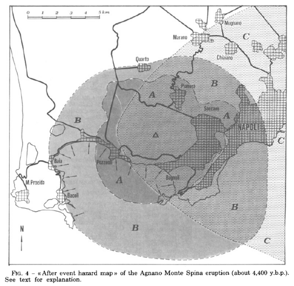
Figure in a journal article
After event hazard map of the Agnano Monte Spina eruption (about 4,400 y.b.p.)
Figure 4 in: Rosi, M. & Santacroce, R. (1984). Volcanic hazard assessment in the Phlegraean Fields: a contribution based on stratigraphic and historical data. Bulletin Volcanologique, 47(2), p. 359-370. https://doi.org/10.1007/BF01961567
Official, Figure in hazard assessment
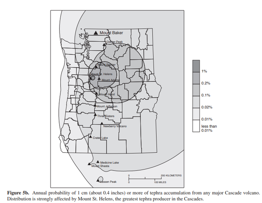
Annual probability of 1 cm (about 0.4 inches) or more of tephra accumulation from any major Cascade volcano
Figure 5b in: Gardner, C.A., Scott, K.M., Miller, C.D., Myers, B., Hildreth, W., & Pringle, P.T. (1995). Potential volcanic hazards from future activity of Mount Baker, Washington. U.S. Geological Survey, Open-File Report 95-498, 16 p., 1 plate, scale 1:100,000. https://doi.org/10.3133/ofr95498
Official, Figure in hazard assessment
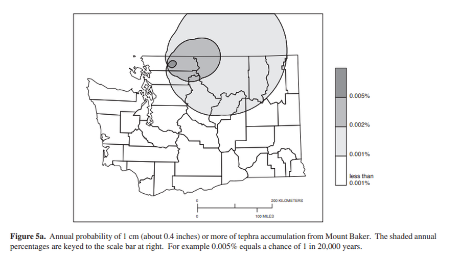
Annual probability of 1 cm (about 0.4 inches) or more of tephra from Mount Baker.
Figure 5a in: Gardner, C.A., Scott, K.M., Miller, C.D., Myers, B., Hildreth, W., & Pringle, P.T. (1995). Potential volcanic hazards from future activity of Mount Baker, Washington. U.S. Geological Survey, Open-File Report 95-498, 16 p., 1 plate, scale 1:100,000. https://doi.org/10.3133/ofr95498
Official, Figure in hazard assessment
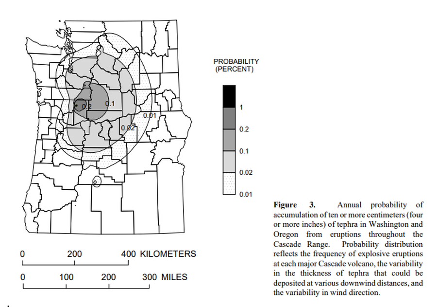
Annual probability of accumulation of ten or more centimeters (four or more inches) of tephra in Washington and Oregon from eruptions throughout the Cascade Range.
Figure 3 in: Wolfe, E.W. & Pierson, T.C. (1995). Volcanic-Hazard Zonation for Mount St. Helens, Washington, 1995. U.S. Geological Survey, Open-File Report 95-497, 12 p., 1 plate. https://doi.org/10.3133/ofr95497
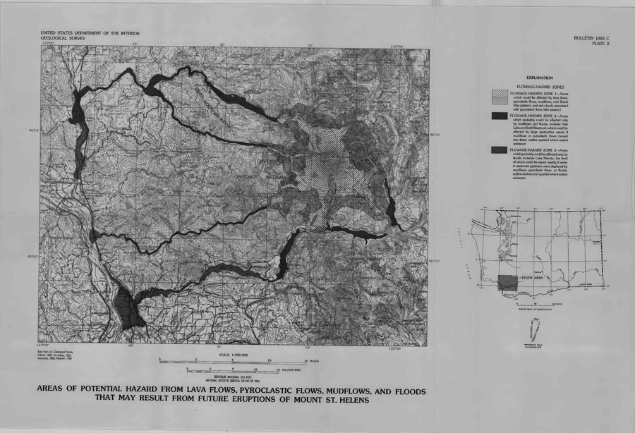
Official, Insert/poster-size map with accompanying report
Areas of Potential Hazard from Lava Flows, Pyroclastic Flows, Mudflows, and Floods that May Result from Future Eruptions of Mount St. Helens
Plate 2 in: Crandell, D.R. & Mullineaux, D.R. (1978). Potential Hazards from Future Eruptions of Mount St. Helens Volcano, Washington. U.S. Geological Survey, Bulletin 1383-C, 26 p. https://doi.org/10.3133/b1383C
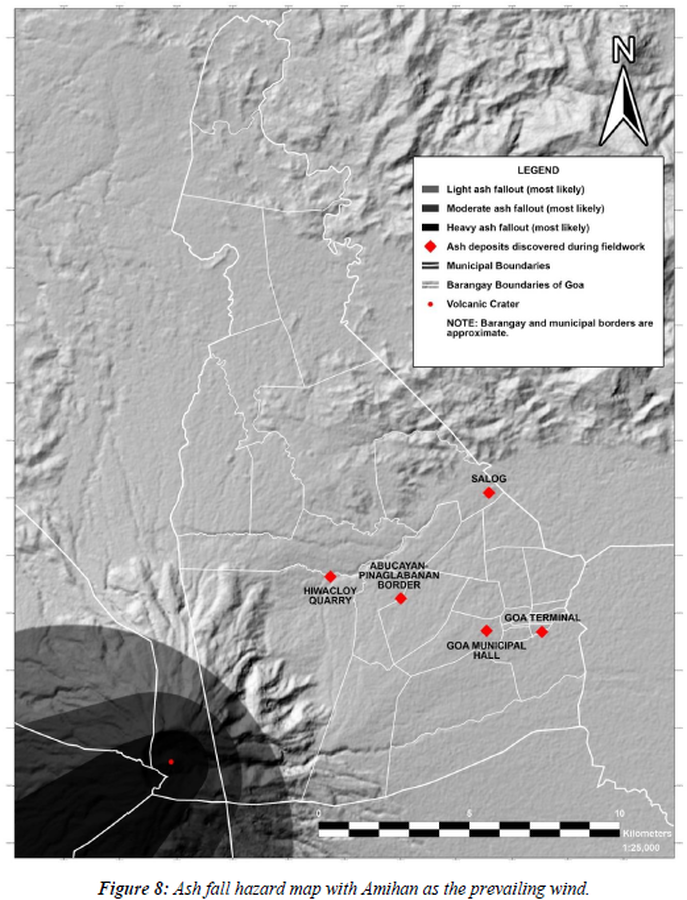
Figure in a thesis or dissertation
Ash fall hazard map with Amihan as the prevailing wind
Figure 8 in: Daita, T.J.E. (2020). Preliminary Volcanic Hazard Assessment of Goa, Camarines Sur, Philippines. Thesis, Partido State University, Goa, Camarines Sur, Philippines.
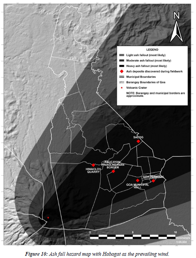
Figure in a thesis or dissertation
Ash fall hazard map with Habagat as the prevailing wind
Figure 10 in: Daita, T.J.E. (2020). Preliminary Volcanic Hazard Assessment of Goa, Camarines Sur, Philippines. Thesis, Partido State University, Goa, Camarines Sur, Philippines.
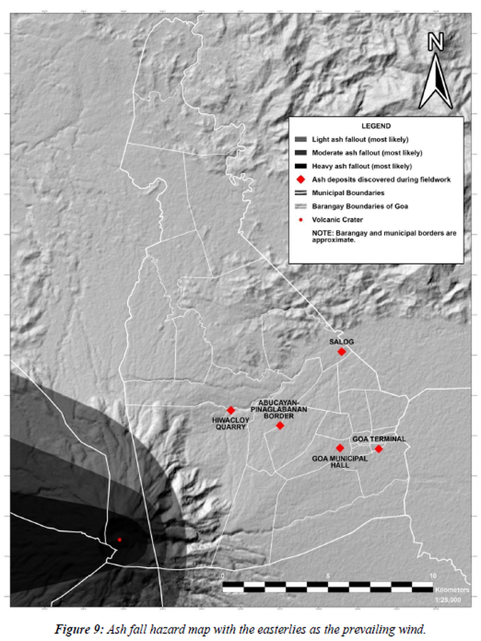
Figure in a thesis or dissertation
Ash fall hazard map with the easterlies as the prevailing wind
Figure 9 in: Daita, T.J.E. (2020). Preliminary Volcanic Hazard Assessment of Goa, Camarines Sur, Philippines. Thesis, Partido State University, Goa, Camarines Sur, Philippines.
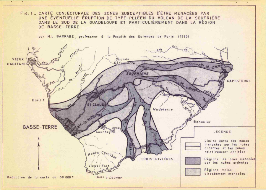
Official, Figure in hazard assessment
Carte Conjecturale des Zones Susceptibles d'etre Menacées par Une Éventuelle Éruption de Type Péleen du Volcan de la Soufrière dans le Sud de la Gaudeloupe et Particulièrement dans la Région de Basse-Terre
(Conjectural Map of Areas Susceptible to Threatened by a Possible Peleen-type Eruption of the Soufriere Volcano in the South of Gaudeloupe and Particularly in the Region of Basse-Terre)
Figure 1 (in reprint) in: Barrabe, M.L. (1960) Rapport sur les risques qui pourraient resulter de la presense du volcan de la Soufriere pour la villa de Basse-Terre, avec une carte de zonation des risques volcaniques au 1/50.000. Report inedit, 6 p. (Reprinted in: Westercamp, D. (1976). Dynamismes Éruptifs et Zonation des Risques Volcaniques a la Sourfrière de Guadeloupe. Bureau de Recherches Géologiques, Service Geologique des Antilles. Reprinted from: Barrabe, M.L. (1960) Rapport sur les risques qui pourraient resulter de la presense du volcan de la Soufriere pour la villa de Basse-Terre, avec une carte de zonation des risques volcaniques au 1/50.000. Report inedit, 6 p.)

Figure in a journal article
Carte de Risque Volcanique
(Volcanic Hazard Map)
Figure 1 in: Tedesco, D. (2003). 1995 Nyiragongo and Nyamulagira activity in the Virunga National Park: A volcanic crisis. Acta vulcanologica, 14(1-2), 149-155.