
Advanced Search for Maps
Showing 1-10 of 213
Official, Map in an information statement
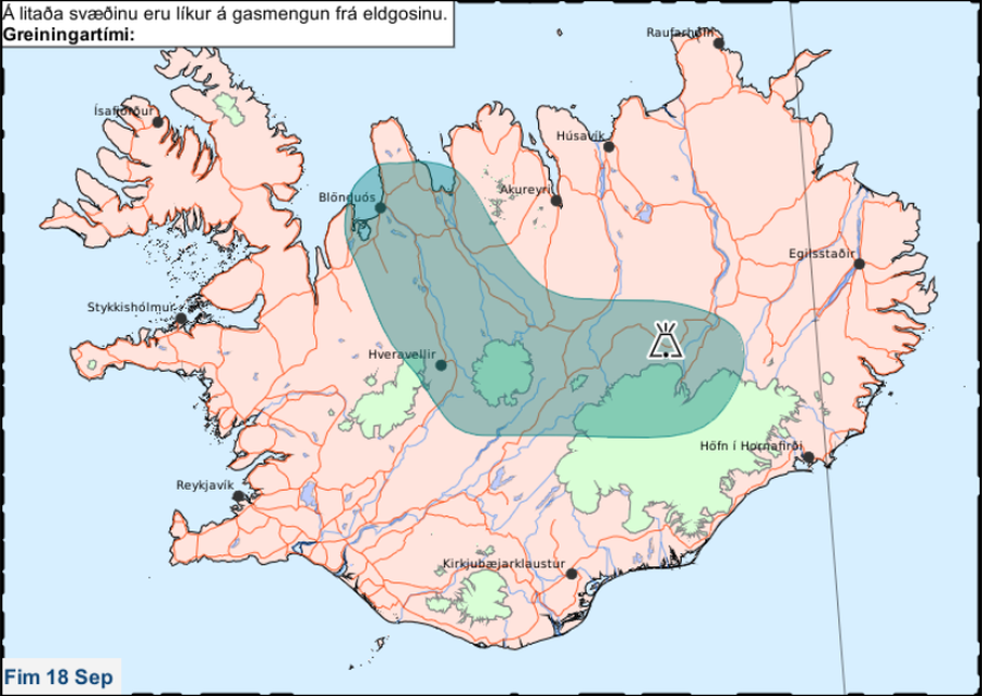
Á litaða svæðinu eru líkur á gasmengun frá eldgosinu. Fim 18 Sep.
(In the colored area there is a likelihood of gas pollution from the eruption. Thu 18 Sep.)
Iceland Meteorological Office (IMO). (2014). Á litaða svæðinu eru líkur á gasmengun frá eldgosinu. Fim 18 Sep.

Figure in a journal article
Absolute probability for areas to be affected by a ballistic impact density >0.001
Figure 12 in: Strehlow, K., Sandri, L., Gottsmann, J. H., Kilgour, G., Rust, A. C., & Tonini, R. (2017). Phreatic eruptions at crater lakes: occurrence statistics and probabilistic hazard forecast. Journal of Applied Volcanology, 6(1), 4. https://doi.org/10.1186/s13617-016-0053-2
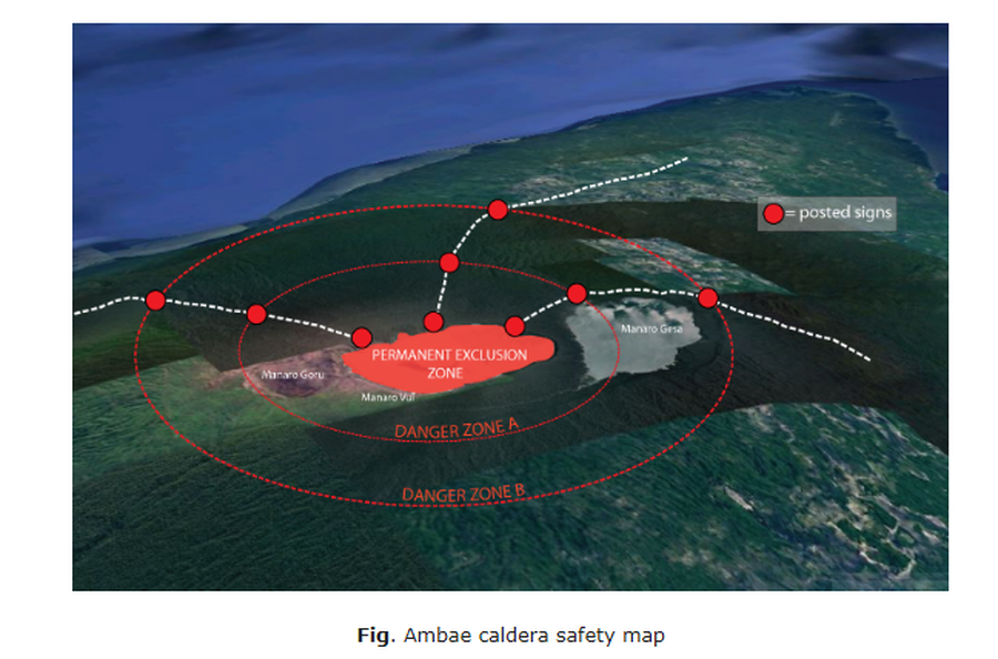
Official, Map in an information statement
Ambae caldera safety map
Figure 1 in: Vanuatu Meteorology & Geo-Hazards Department. (2020). Vanuatu Volcano Alert Bulletin No. 4 - Ambae Activity, Thursday May 28th 2020.
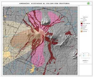
Official, Map in an information statement
Amenazas Asociadas al Volcán San Cristóbal
(Hazards Associated with the San Cristobal Volcano)
Instituto Nicaragüense de Estudios Territoriales (INETER). (2006). Amenazas Asociadas al Volcán San Cristóbal. https://webserver2.ineter.gob.ni/vol/cristobal/Chinandega.gif
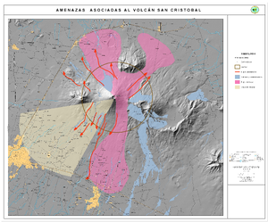
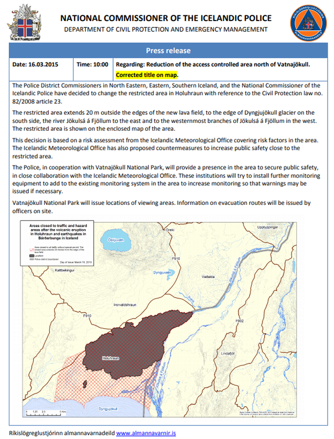
Official, Map in an information statement
Areas closed to traffic and hazard areas after the volcanic eruption in Holuhraun and earthquakes in Bárðarbunga in Iceland
National Commisioner of the Icelandic Police. (2015). Press Release 16.03.2015 10:00 Regarding: Reduction of the access controlled area north of Vatnajökull.
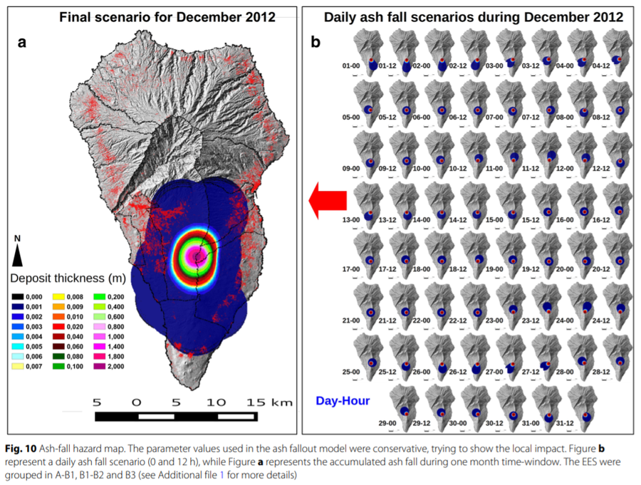
Figure in a journal article
Ash-fall hazard map
Figure 10 in: Marrero, J. M., García, A., Berrocoso, M., Llinares, Á., Rodríguez-Losada, A., & Ortiz, R. (2019). Strategies for the development of volcanic hazard maps in monogenetic volcanic fields: the example of La Palma (Canary Islands). Journal of Applied Volcanology, 8(1), 6. https://doi.org/10.1186/s13617-019-0085-5
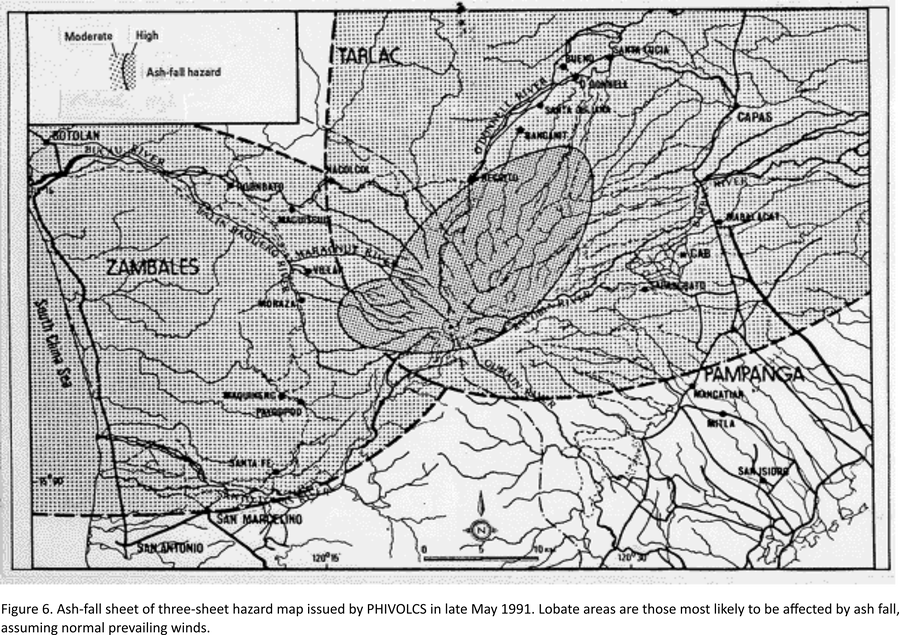
Official, Map in an information statement
Ash-fall sheet of three-sheet hazard map issued by PHIVOLCS in late May 1991
Figure 6 in: Punongbayan, R.S., Newhall, C.G., Bautista, L.P., Garcia, D., Harlow, D.H., Hoblitt, R.P., Sabit, J.P., & Solidum, R.U. (1996). Eruption hazard assessments and warnings. In: Newhall, C.G. & Punongbayan, R.S. (Eds.) Fire and Mud: Eruptions and Lahars of Mount Pinatubo, Philippines. Philippine Institute of Volcanology and Seismology, Quezon City; University of Washington Press, Seattle.

Official, Figure on website
Ashfall model output for Yellowstone supereruption
U.S. Geological Survey (USGS). (2014). Ashfall model output for Yellowstone supereruption. U.S. Geological Survey. Modeling the Ash Distribution of a Yellowstone Supereruption (2014). https://www.usgs.gov/volcanoes/yellowstone/modeling-ash-distribution-yellowstone-supereruption-2014 (Simplified from: Mastin et al. 2014)
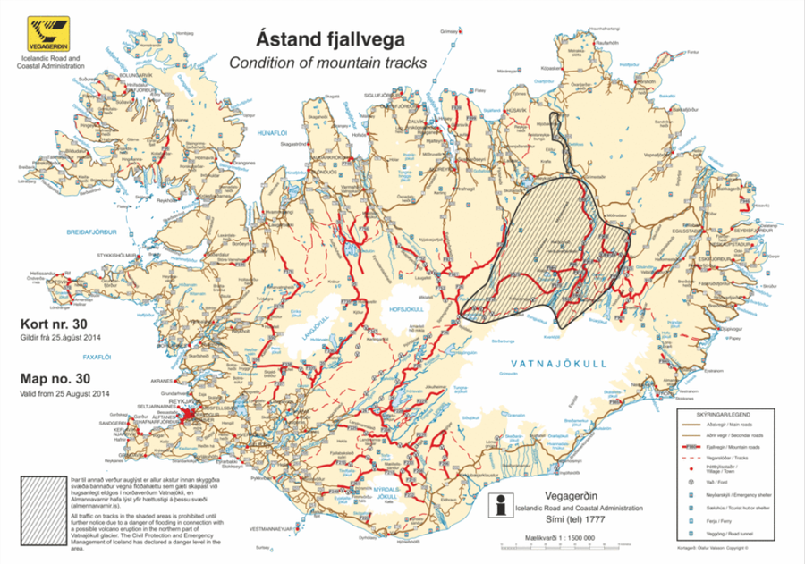
Official, Map in an information statement
Ástand fjallvega
(Condition of mountain tracks)
Icelandic Road and Coastal Administration. (2014). Condition of mountain tracks. Map no. 30, valid from 25 August 2014.