
Advanced Search for Maps
Showing 31-40 of 247
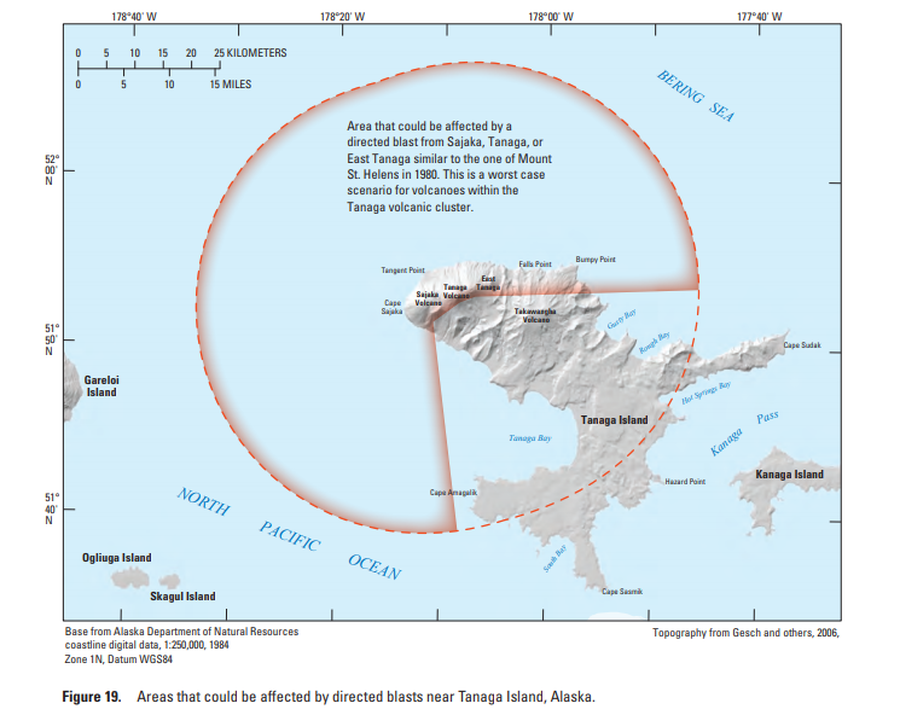
Official, Figure in hazard assessment
Areas that could be affected by directed blasts near Tanaga Island, Alaska
Figure 19 in: Coombs, M.L., McGimsey, R.G. & Browne, B.L. (2007). Preliminary volcano-hazard assessment for the Tanaga volcanic cluster, Tanaga Island, Alaska. U.S. Geological Survey, Scientific Investigations Report 2007-5094, 41 p., 1 plate. https://doi.org/10.3133/sir20075094
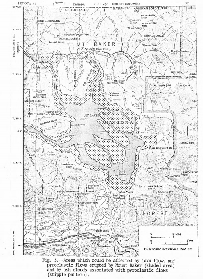
Official, Figure in hazard assessment
Areas which could be affected by lava flows and pyroclastic flows erupted from Mount Baker and by ash clouds associated with pyroclastic flows
Figure 3 in: Hyde, J.H. & Crandell, D.R. (1975). Origin and age of postglacial deposits and assessment of potential hazards from future eruptions of Mount Baker, Washington. U.S. Geological Survey, Open-File Report 75-286, 22 p. https://doi.org/10.3133/ofr75286
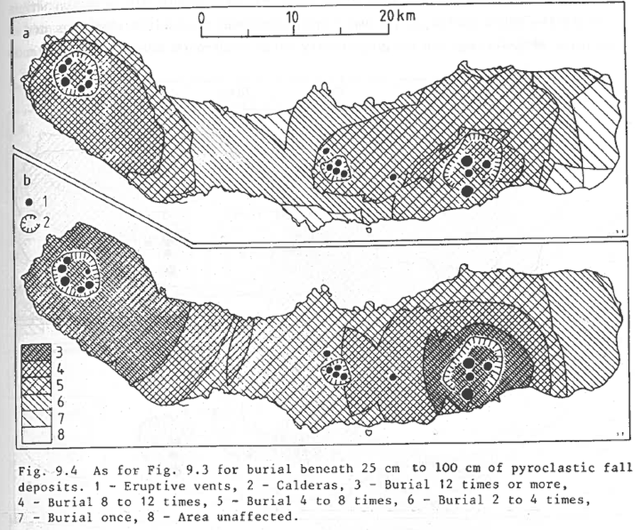
Figure in a journal article
As for Fig. 9.3 for burial beneath 25 to 100 cm of pyroclastic fall deposits
Figure 9.4 in: Booth, B., Croasdale, R., & Walker, G.L. (1983). Volcanic hazard on Sao Miguel, Azores. In: Tazieff, H. & Sabroux, J.C. (eds.). Forecasting Volcanic Events. Elsevier, Amsterdam. p. 99-109.
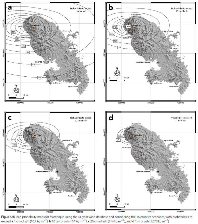
Figure in a journal article
Ash load probability maps for Martinique using the 41-year wind database and considering the 16 eruptive scenarios
Figure 8 in: Michaud-Dubuy, A., Carazzo, G., & Kaminski, E. (2021). Volcanic hazard assessment for tephra fallout in Martinique. Journal of Applied Volcanology, 10(1), 1-20. https://doi.org/10.1186/s13617-021-00106-7.
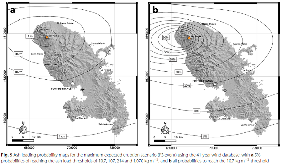
Figure in a journal article
Ash loading probability maps for the maximum expected eruption scenario
Figure 5 in: Michaud-Dubuy, A., Carazzo, G., & Kaminski, E. (2021). Volcanic hazard assessment for tephra fallout in Martinique. Journal of Applied Volcanology, 10(1), 1-20. https://doi.org/10.1186/s13617-021-00106-7.
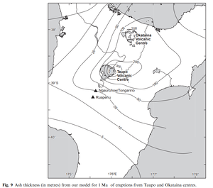
Official, Figure in a journal article
Ash thickness (in metres) from our model for 1 Ma of eruptions from Taupo and Okataina centres
Figure 9 in: Hurst, T. & Smith, W. (2010). Volcanic ashfall in New Zealand–probabilistic hazard modelling for multiple sources. New Zealand Journal of Geology and Geophysics, 53(1), 1-14. https://doi.org/10.1080/00288301003631129
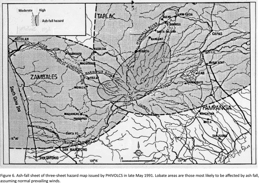
Official, Map in an information statement
Ash-fall sheet of three-sheet hazard map issued by PHIVOLCS in late May 1991
Figure 6 in: Punongbayan, R.S., Newhall, C.G., Bautista, L.P., Garcia, D., Harlow, D.H., Hoblitt, R.P., Sabit, J.P., & Solidum, R.U. (1996). Eruption hazard assessments and warnings. In: Newhall, C.G. & Punongbayan, R.S. (Eds.) Fire and Mud: Eruptions and Lahars of Mount Pinatubo, Philippines. Philippine Institute of Volcanology and Seismology, Quezon City; University of Washington Press, Seattle.
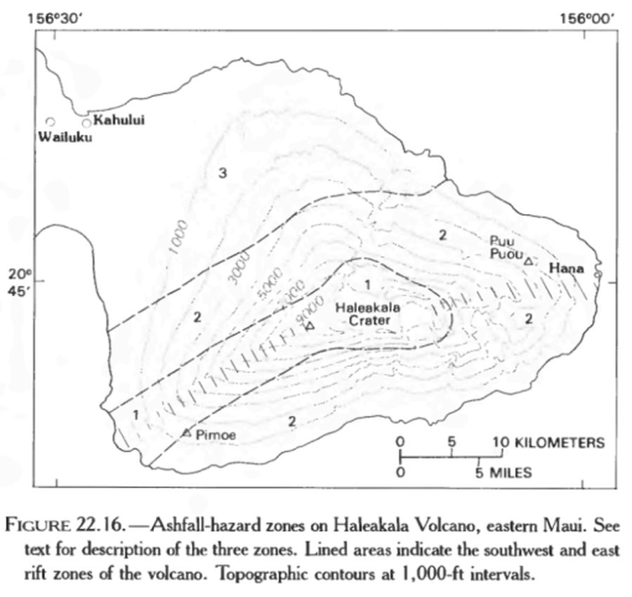
Official, Figure in hazard assessment
Ashfall-hazard zones on Haleakala Volcano, eastern Maui.
Figure 22.16 in: Mullineaux, D.R., Peterson, D.W., & Crandell, D.R. (1987). Volcanic hazards in the Hawaiian Islands. In: Decker, R.W., Wright, T.L., & Stauffer, P.H. (Eds.) Volcanism in Hawaii. US Geological Survey Professional Paper 1350, Chapter 22, p. 599-621. https://doi.org/10.3133/pp1350
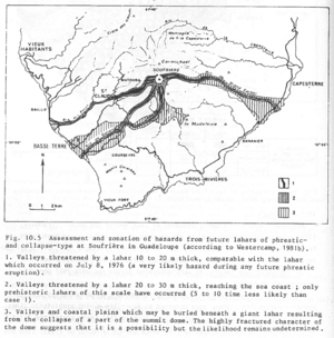
Figure in a journal article
Assessment and zonation of hazards from future lahars of phreatic and collapse-type at Soufrière in Guadeloupe (according to Westercamp, 1981b)
Figure 10.5 in: Westercamp, D. (1983). Appraisal and zonation of volcanic hazards in the French Lesser Antilles: preliminary results. In: Tazieff, H. & Sabroux, J.-C. (Eds.) Forecasting Volcanic Events, Elsevier, Amsterdam, p. 111-130.
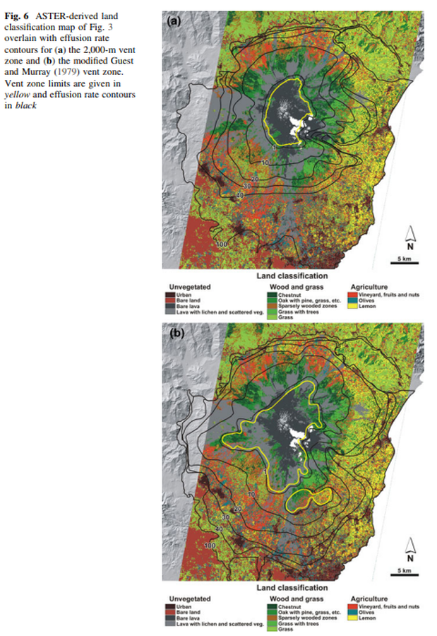
Figure in a journal article
ASTER-derived land classification map of Fig. 3 overlain with effusion rate contours for the 2,000-m vent zone and the modified Guest and Murray (1979) vent zone
Figure 6 in: Harris, A. J., Favalli, M., Wright, R., & Garbeil, H. (2011). Hazard assessment at Mount Etna using a hybrid lava flow inundation model and satellite-based land classification. Natural Hazards, 58(3), 1001-1027. https://doi.org/10.1007/s11069-010-9709-0