
Advanced Search for Maps
Showing 41-50 of 247
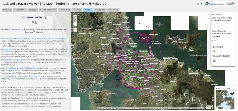
Official, Interactive web-based map
Auckland's Hazard Viewer Volcanic Activity
Auckland Council. Auckland's Hazard Viewer: Volcanic Activity.

Figure in a thesis or dissertation
Batur Community Hazard Map
Figure 5.5 in: Donovan, K.H.M. (2010). Cultural responses to volcanic hazards on Mt Merapi, Indonesia. University of Plymouth, PhD Dissertation.
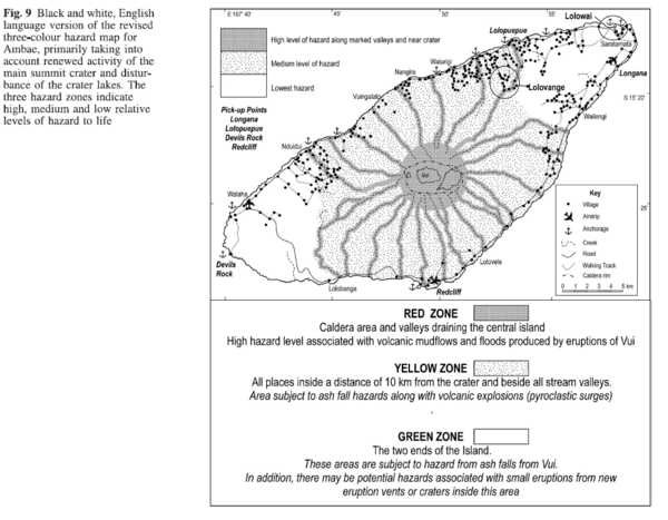
Figure in a journal article
Black and white, English language version of the revised three-colour hazard map for Ambae, primarily taking into account renewed activity of the main summit crater and disturbance of the crater lakes
Figure 9 in: Cronin, S.J., Gaylord, D.R., Charley, D., Alloway, B.V., Wallez, S., & Esau, J.W. (2004). Participatory methods of incorporating scientific with traditional knowledge for volcanic hazard management on Ambae Island, Vanuatu. Bulletin of volcanology, 66(7), p. 652-668. https://doi.org/10.1007/s00445-004-0347-9
Official, Figure in hazard assessment
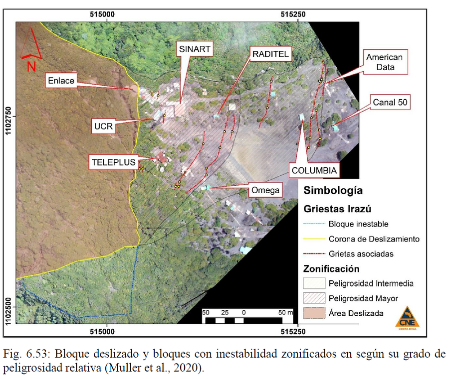
Bloque deslizado y bloques con inestabilidad zonificados en según su grado de peligrosidad relativa
(Sliding block and blocks with instability zoned according to their degree of relative danger)
Figure 6.53 in: Alvarado, G.E., Campos-Durán, D., Brenes-André, J., Alpízar, Y., Núñez, S., Esquivel, L., Sibaja, J.P. & Fallas, B. (2021). Peligro Volcánico del Irazú, Costa Rica. Comisión Nacional de Prevención de Riesgos y Atención de Emergencias (CNE). Deciembre 2021. (Modified from: Muller et al., 2020).
Official, Figure in hazard assessment
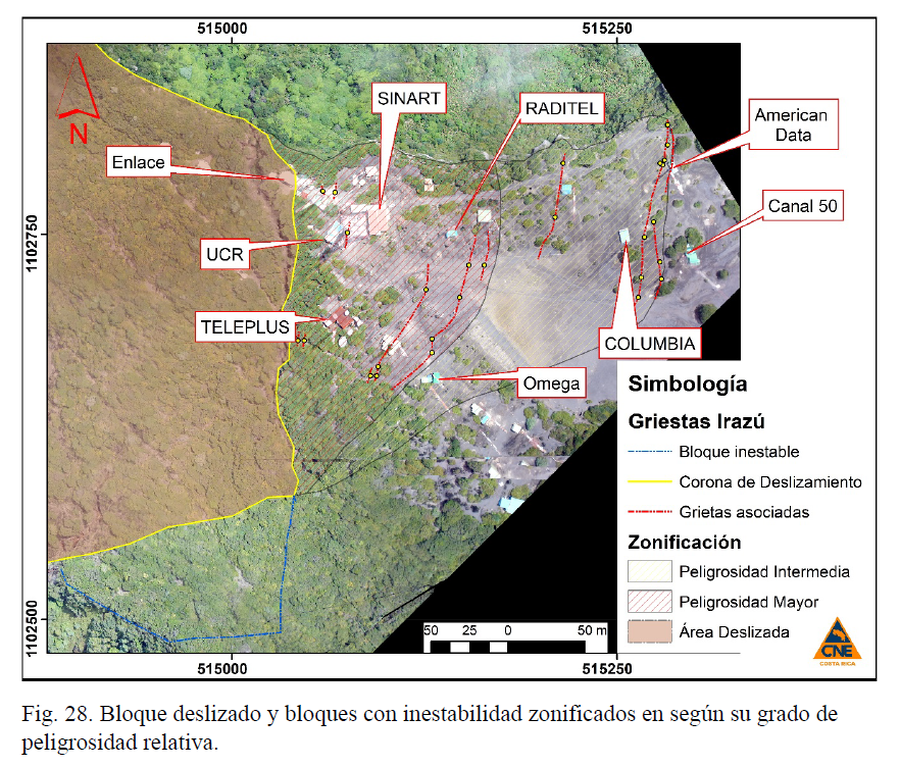
Bloque deslizado y bloques con inestabilidad zonificados en según su grado de peligrosidad relativa.
(Sliding block and blocks with instability zoned according to their degree of relative danger)
Figure 28 in: Muller, C., Pacheco, J., Angarita, M., Alvarado, G.E., Sánchez, B. & Avard, G. (2020). El deslizamiento de las Torres del Irazú del 2020 (Costa Rica): antecedentes, colapso y situación actual. OVSICORI-UNA y CNE. Informe Interno.
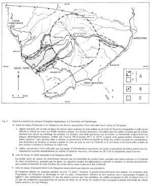
Figure in a journal article
Carte de zonation des risques d'éruption magmatique à la Soufrière de Guadeloupe
(Zonation map of magmatic eruption risks at Soufrière in Guadeloupe)
Figure 5 in: Westercamp, D. (1981). Cartographie du risque volcanique a la soufriere de guadeloupe: Retrospective et tendance actuelle. Bulletin of the International Association of Engineering Geology-Bulletin de l'Association Internationale de Géologie de l'Ingénieur, 23(1), p. 25-32. https://doi.org/10.1007/BF02594723
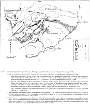
Figure in a journal article
Carte de zonation des risques d'éruption phréatique à la Soufrière de Guadeloupe (d'après Westercamp 1977b)
(Zonation map of phreatic eruption risks at Soufrière in Guadeloupe (from Westercamp 1977b))
Figure 4 in: Westercamp, D. (1981). Cartographie du risque volcanique a la soufriere de guadeloupe: Retrospective et tendance actuelle. Bulletin of the International Association of Engineering Geology-Bulletin de l'Association Internationale de Géologie de l'Ingénieur, 23(1), p. 25-32. https://doi.org/10.1007/BF02594723
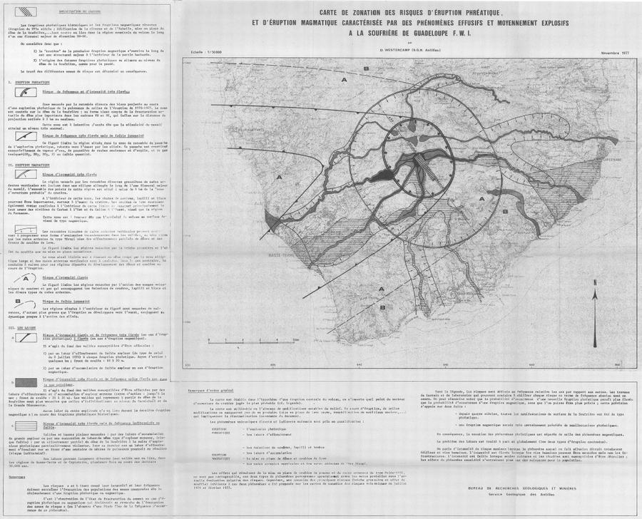
Official, Insert/poster-size map with accompanying report
Carte de Zonation des Risques d'Éruption Phréatique, et d'Éruption Magmatique Caractérisée par des Phénomènes Effusifs et Moyennement Explosifs à la Soufrière de Guadeloupe F.W.I.
(Map of Risk of Phreatic Eruption, and Magmatic Eruption Characterized by Effusive and Moderately Explosive Phenomena at Soufrière de Guadeloupe F.W.I.)
Insert in: Westercamp, D. (1977) Levés géologiques, évaluation et zonation des risques volcaniques à la Soufrière de Guadeloupe F. W. I. (Rapport de mission) Mai-Juin 1977. Délégation Générale a la Recherche Scientifique et Technique. 77 Ant 29
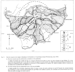
Figure in a journal article
Carte de zonation des risques volcaniques á la Soufrière de Guadeloupe (d'ápres Westercamp, Juin 1976)
(Zonation map of volcanic risks at Soufrière in Guadeloupe (after Westercamp, June 1976))
Figure 2 in: Westercamp, D. (1981). Cartographie du risque volcanique a la soufriere de guadeloupe: Retrospective et tendance actuelle. Bulletin of the International Association of Engineering Geology-Bulletin de l'Association Internationale de Géologie de l'Ingénieur, 23(1), p. 25-32. https://doi.org/10.1007/BF02594723
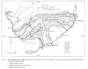
Figure in a journal article
Carte montrant les zones susceptibles d'être menacées par une éventuelle éruption de type péléen du volcan de la Soufrière de Guadeloupe (d'ápres Barrabe 1960)
(Map showing the areas likely to be threatened by a possible Pelean-type eruption of the Soufrière volcano in Guadeloupe (from Barrabe 1960).)
Figure 1 in: Westercamp, D. (1981). Cartographie du risque volcanique a la soufriere de guadeloupe: Retrospective et tendance actuelle. Bulletin of the International Association of Engineering Geology-Bulletin de l'Association Internationale de Géologie de l'Ingénieur, 23(1), p. 25-32. https://doi.org/10.1007/BF02594723