
Advanced Search for Maps
Showing 601-610 of 2217
Official, Insert/poster-size map with accompanying report
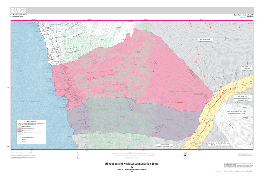
Hōnaunau and Kealakekua Inundation Zones
Sheet 9 in: Trusdell, F.A. & Zoeller, M.H. (2017). Lava inundation zone maps for Mauna Loa, Island of Hawaiʻi, Hawaii. U.S. Geological Survey, Scientific Investigations Map 3387, 12 p., 10 sheets. https://doi.org/10.3133/sim3387
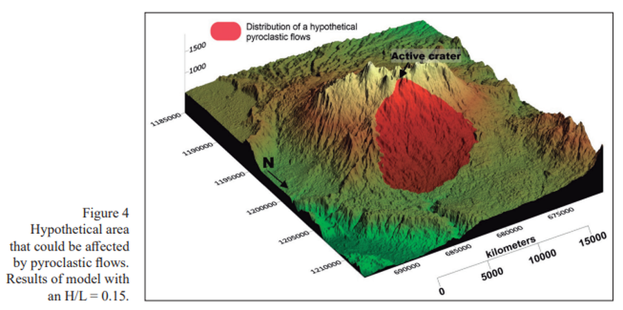
Figure in a journal article
Hypothetical area that could be affected by pyroclastic flows
Figure 4 in: Alpízar, Y., Fernández, M., Ramírez, C., & Arroyo, D. (2019). Hazard Map of Rincón de la Vieja Volcano, Costa Rica: Qualitative Integration of Computer Simulations and Geological Data. Anuario do Instituto de Geociencias, 42(3). http://dx.doi.org/10.11137/2019_3_474_488
Official, Figure in hazard assessment
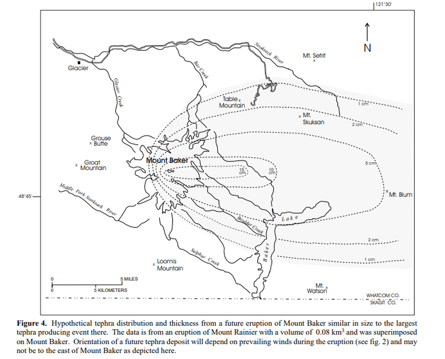
Hypothetical tephra distribution and thickness from a future eruptions of Mount Baker similar in size to the largest tephra producing event there
Figure 4 in: Gardner, C.A., Scott, K.M., Miller, C.D., Myers, B., Hildreth, W., & Pringle, P.T. (1995). Potential volcanic hazards from future activity of Mount Baker, Washington. U.S. Geological Survey, Open-File Report 95-498, 16 p., 1 plate, scale 1:100,000. https://doi.org/10.3133/ofr95498
Official (foreign agency), Insert/poster-size map with accompanying report
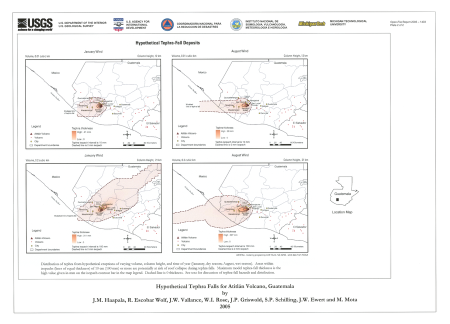
Hypothetical Tephra-fall Deposits
Plate 2 in: Haapala, J. M., Escobar Wolf, R., Vallance, J. W., Rose, W. I., Griswold, J. P., Schilling, S. P., Ewert, J.W., & Mota, M. (2005). Volcanic hazards at Atitlan volcano, Guatemala. U.S. Geological Survey, Open-File Report, 1403. https://doi.org/10.3133/ofr20051403
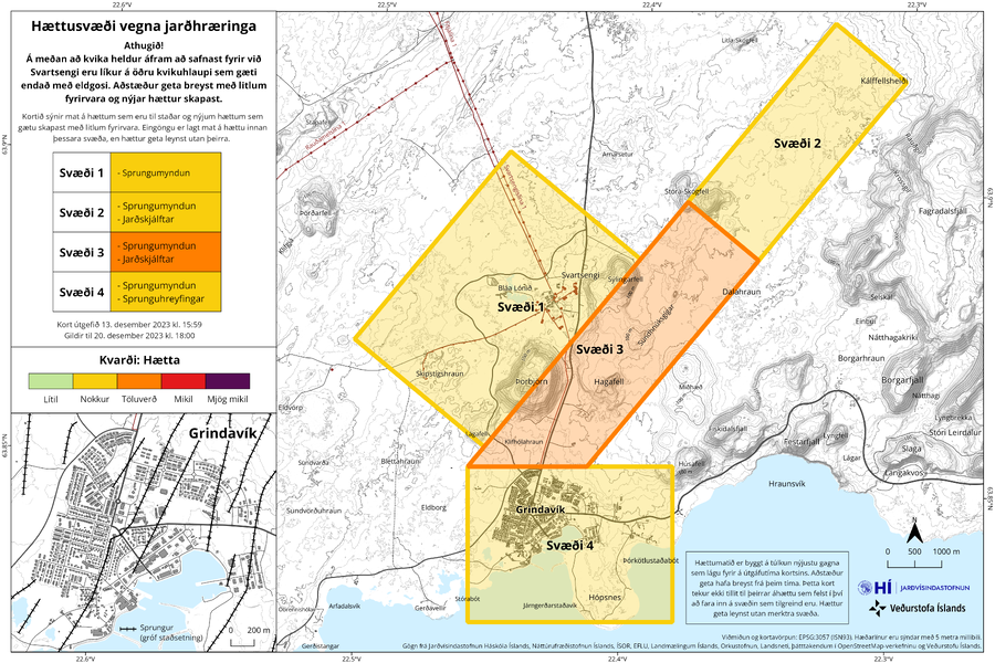
Official, Figure on website
Hættusvæði vegna jarðhræringa
(Danger zone due to earthquakes)
Icelandic Meteorological Office (IMO). (2023). Hættusvæði vegna jarðhræringa, 13. desember 2023.
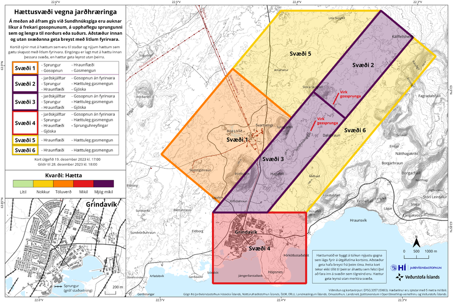
Official, Figure on website
Hættusvæði vegna jarðhræringa
(Danger zone due to earthquakes)
Icelandic Meteorological Office (IMO). (2023). Hættusvæði vegna jarðhræringa, 19. desember 2023.
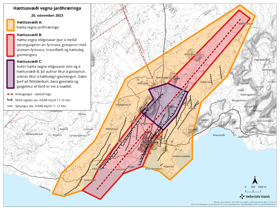
Official, Figure on website
Hættusvæði vegna jarðhræringa, 20. nóvember 2023
(Danger zone due to earthquakes, November 20, 2023)
Icelandic Meteorological Office (IMO). (2023). Hættusvæði vegna jarðhræringa, 20. nóvember 2023.
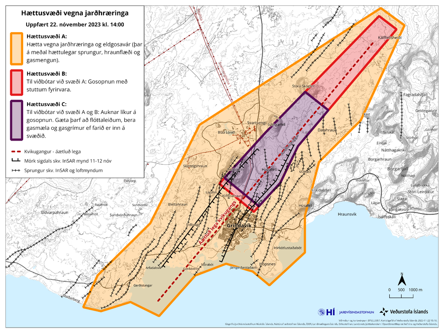
Official, Figure on website
Hættusvæði vegna jarðhræringa, Uppfært 22. nóvember 2023 kl. 14:00
(Danger zone due to earthquakes, Updated November 22, 2023 at 14:00)
Icelandic Meteorological Office (IMO). (2023). Hættusvæði vegna jarðhræringa, 20. nóvember 2023.
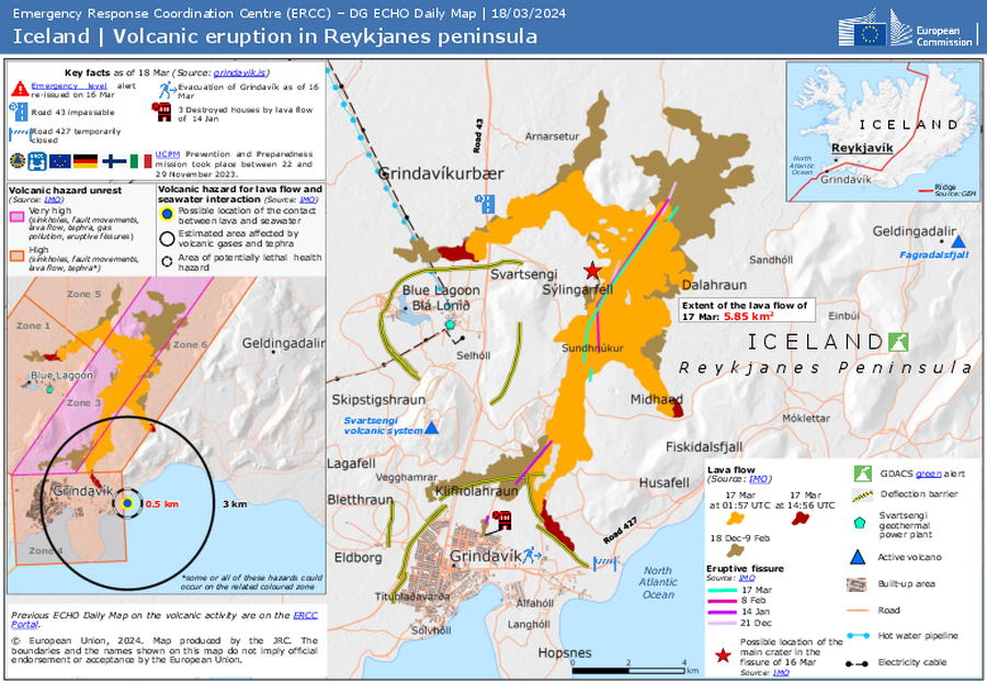
Official, Figure on website
Iceland | Volcanic eruption in Reykjanes peninsula
Emergency Response Coordination Centre (ERCC). (2024). ECHO Daily Map of 18 March 2024. https://erccportal.jrc.ec.europa.eu/ECHO-Products/Maps#/maps/4825
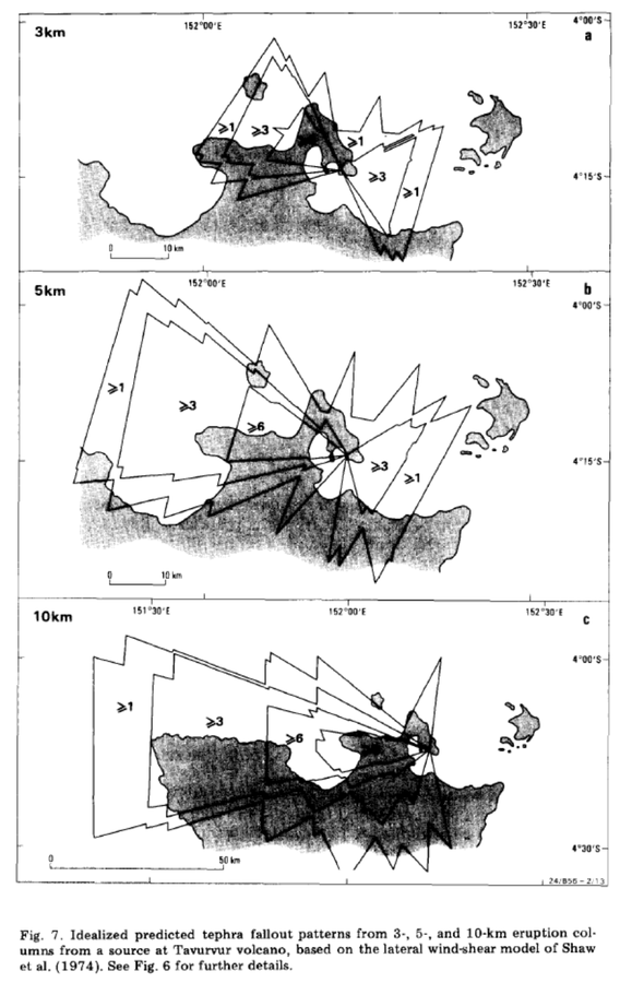
Official, Figure in a journal article
Idealized predicted tephra fallout patterns from 3-, 5-, and 10-km eruption columns from a source at Tavurvur volcano
Figure 7 in: McKee, C. O., Johnson, R. W., Lowenstein, P. L., Riley, S. J., Blong, R. J., De Saint Ours, P., & Talai, B. (1985). Rabaul caldera, Papua New Guinea: volcanic hazards, surveillance, and eruption contingency planning. Journal of Volcanology and Geothermal Research, 23(3-4), p. 195-237. https://doi.org/10.1016/0377-0273(85)90035-6