
Advanced Search for Maps
Showing 11-20 of 220
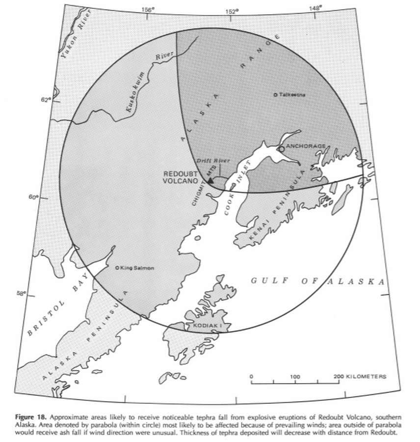
Official, Figure in hazard assessment
Approximate areas likely to receive noticeable tephra fall from explosive eruptions of Redoubt Volcano, southern Alaska
Figure 18 in: Till, A.B., Yount, M.E., & Riehle, J.R. (1993). Redoubt Volcano, southern Alaska; a hazard assessment based on eruptive activity through 1968. U.S. Geological Survey, Bulletin 1996, 19 p., 1 plate. https://doi.org/10.3133/b1996
Official, Figure in hazard assessment
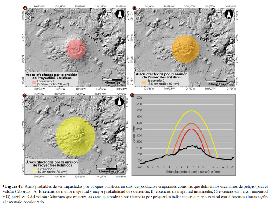
Áreas afectadas por la emisión de Proyectiles Balísticos
(Areas affected by the emission of Ballistic Projectiles)
Figure 48 in: Ferrés López, D., Sieron, K., González Zuccolotto, K., Constantinescu, R., Agustín Flores, J., Siebe Grabach, C., Capra Pedol, L., Connor, L., & Connor, C.B. (2019). Memoria técnica del mapa de peligros del volcán Ceboruco (Nayarit). Monografías del Instituto de Geofísica, 24.
Official, Figure in hazard assessment
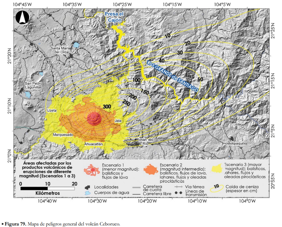
Áreas afectadas por los productos volcánicos de erupciones de diferente magntiud (Escenarios 1 a 3)
(Areas affected by the volcanic products of eruptions of different magnitudes (Scenarios 1 to 3))
Figure 79 in: Ferrés López, D., Sieron, K., González Zuccolotto, K., Constantinescu, R., Agustín Flores, J., Siebe Grabach, C., Capra Pedol, L., Connor, L., & Connor, C.B. (2019). Memoria técnica del mapa de peligros del volcán Ceboruco (Nayarit). Monografías del Instituto de Geofísica, 24.
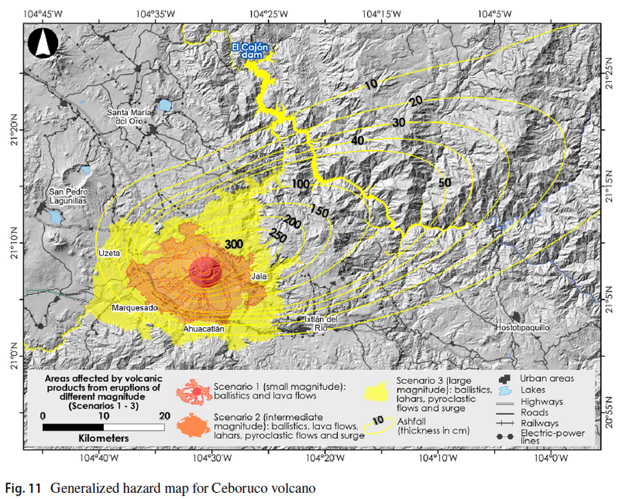
Figure in a journal article
Areas affected by volcanic products from eruptions of different magnitude (Scenarios 1-3)
Figure 11 in: Sieron, K., Ferrés, D., Siebe, C., Constantinescu, R., Capra, L., Connor, C., Connor, L., Groppelli, G. & Zuccolotto, K.G. (2019). Ceboruco hazard map: part II—modeling volcanic phenomena and construction of the general hazard map. Natural Hazards, 96(2), p. 893-933. https://doi.org/10.1007/s11069-019-03577-5
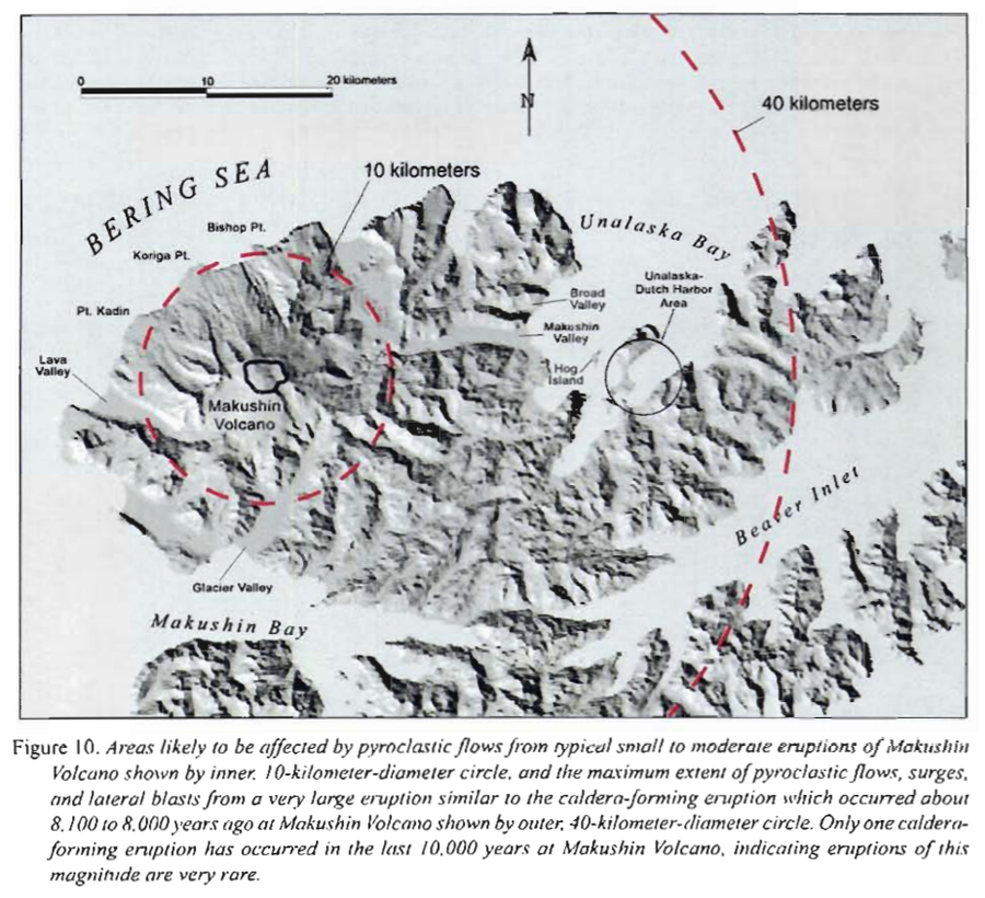
Official, Figure in hazard assessment
Areas likely to be affected by pyroclastic flows from typical small to moderate eruptions of Makushin
Figure 10 in: Beget, J.E., Nye, C.J. & Bean, K.W. (2000). Preliminary volcano-hazard assessment for Makushin Volcano, Alaska. Alaska Division of Geological & Geophysical Surveys, Report of Investigation 2000-4, 22 p., 1 sheet, scale 1:100,000.
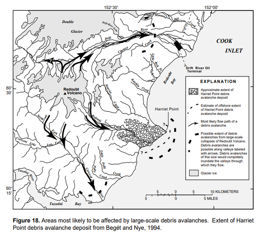
Official, Figure in hazard assessment
Areas most likely to be affected by large-scale debris avalanches
Figure 18 in: Waythomas, C.F., Dorava, J.M., Miller, T.P., Neal, C.A. & McGimsey, R.G. (1997). Preliminary volcano-hazard assessment for Redoubt Volcano, Alaska. U.S. Geological Survey, Open-File Report 97-857, 40 p., 1 plate. https://doi.org/10.3133/ofr97857
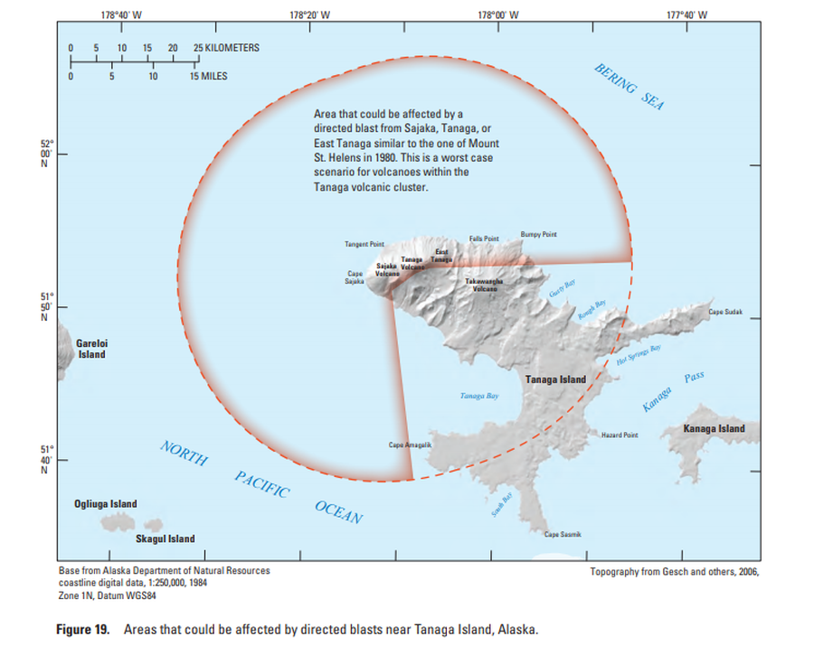
Official, Figure in hazard assessment
Areas that could be affected by directed blasts near Tanaga Island, Alaska
Figure 19 in: Coombs, M.L., McGimsey, R.G. & Browne, B.L. (2007). Preliminary volcano-hazard assessment for the Tanaga volcanic cluster, Tanaga Island, Alaska. U.S. Geological Survey, Scientific Investigations Report 2007-5094, 41 p., 1 plate. https://doi.org/10.3133/sir20075094
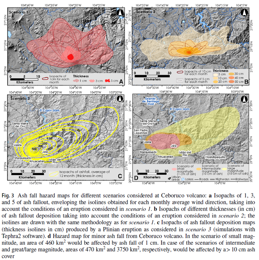
Figure in a journal article
Ash fall hazard maps for different scenarios considered at Ceboruco volcano
Figure 3 in: Sieron, K., Ferrés, D., Siebe, C., Constantinescu, R., Capra, L., Connor, C., Connor, L., Groppelli, G. & Zuccolotto, K.G. (2019). Ceboruco hazard map: part II—modeling volcanic phenomena and construction of the general hazard map. Natural Hazards, 96(2), p. 893-933. https://doi.org/10.1007/s11069-019-03577-5
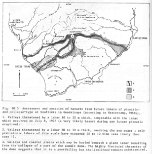
Figure in a journal article
Assessment and zonation of hazards from future lahars of phreatic and collapse-type at Soufrière in Guadeloupe (according to Westercamp, 1981b)
Figure 10.5 in: Westercamp, D. (1983). Appraisal and zonation of volcanic hazards in the French Lesser Antilles: preliminary results. In: Tazieff, H. & Sabroux, J.-C. (Eds.) Forecasting Volcanic Events, Elsevier, Amsterdam, p. 111-130.
Fujisan, Japan
Official, Figure in hazard assessment
Assumed crater range for each scale
Figure 4.1.4 in: Mt. Fuji Hazard Map Review Committee. (2004). Mt. Fuji Hazard Map Review Committee Report. June 2004. https://www.bousai.go.jp/kazan/fuji_map/pdf/report_200406.pdf
Official, Figure in hazard assessment
Assumed crater range for each scale
Figure 4.1.4 in: Mt. Fuji Hazard Map Review Committee. (2004). Mt. Fuji Hazard Map Review Committee Report. June 2004. https://www.bousai.go.jp/kazan/fuji_map/pdf/report_200406.pdf