
Advanced Search for Maps
Showing 61-70 of 220
Official (foreign agency), Insert/poster-size map with accompanying report
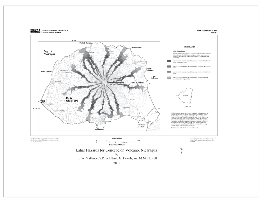
Lahar Hazards for Concepción Volcano, Nicaragua
Plate 1 in: Vallance, J.W., Schilling, S.P., Devoli, G., & Howell, M.M. (2001). Lahar hazards at Concepción volcano, Nicaragua. U.S. Geological Survey, Open File Report 2001-457, 15 p., 1 plate. https://doi.org/10.3133/ofr01457
Official (foreign agency), Insert/poster-size map with accompanying report
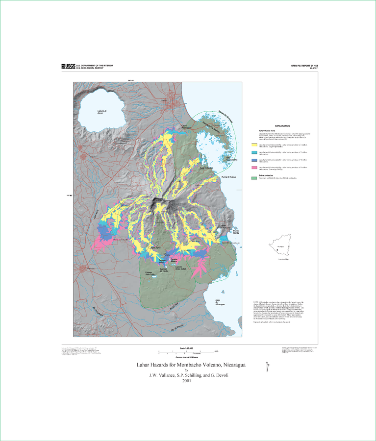
Lahar Hazards for Mombacho Volcano, Nicaragua
Plate 1 (Color) in: Vallance, J.W., Schilling, S.P., Devoli, G. (2001). Lahar Hazards at Mombacho Volcano, Nicaragua. U.S. Geological Survey, Open-File Report 01-455, 16 p., 1 plate. https://doi.org/10.3133/ofr01455
Official (foreign agency), Insert/poster-size map with accompanying report
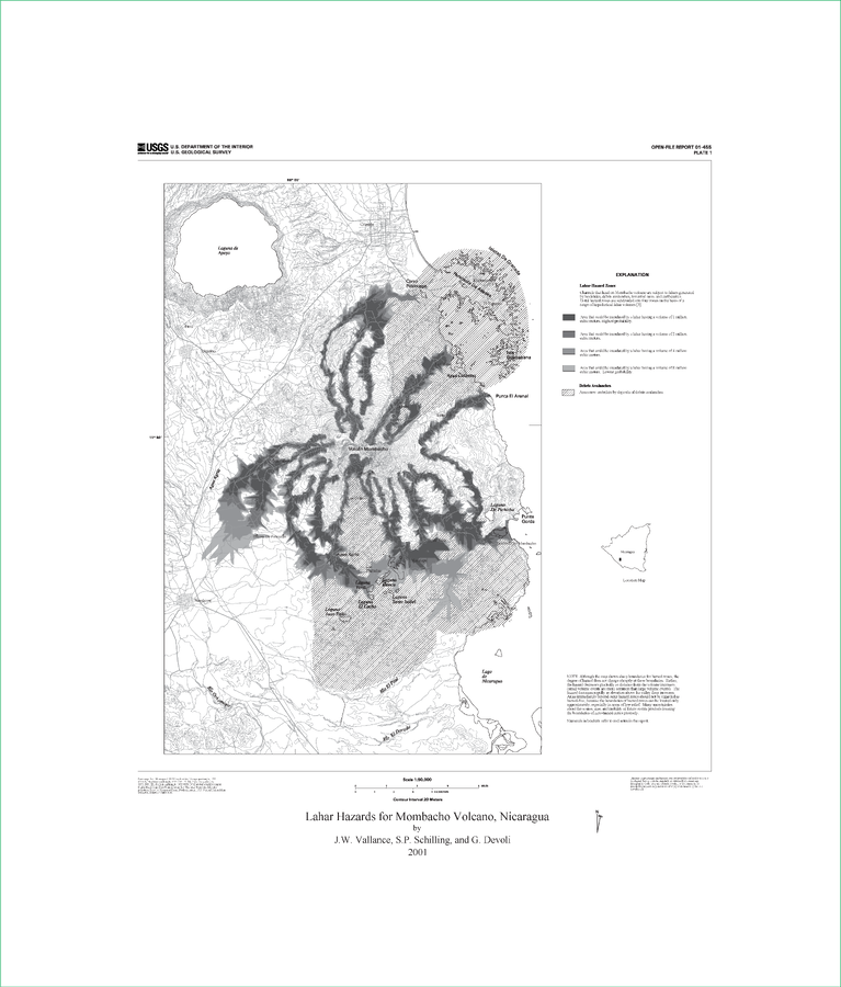
Lahar Hazards for Mombacho Volcano, Nicaragua
Plate 1 (B&W) in: Vallance, J.W., Schilling, S.P., Devoli, G. (2001). Lahar Hazards at Mombacho Volcano, Nicaragua. U.S. Geological Survey, Open-File Report 01-455, 16 p., 1 plate. https://doi.org/10.3133/ofr01455
Official (foreign agency), Insert/poster-size map with accompanying report
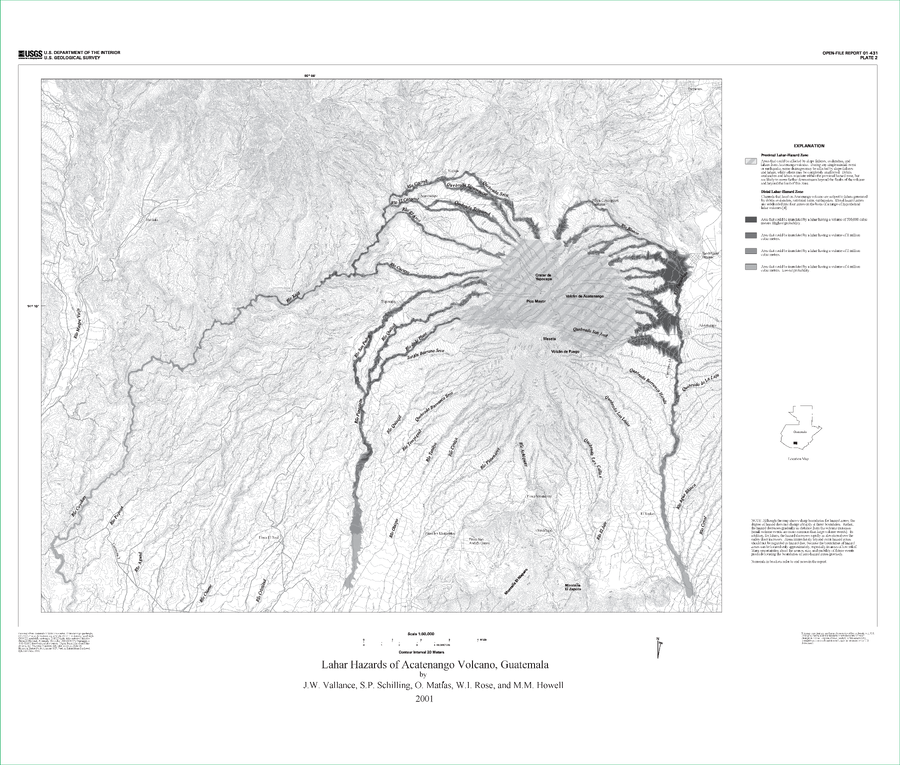
Lahar Hazards of Acatenango Volcano, Guatemala
Plate 2 in: Vallance, J.W., Schilling, S.P., Matías, O., Rose, W.I. & Howell, M.M. (2001). Volcano Hazards at Fuego and Acatenango, Guatemala. U.S. Geological Survey, Open-File Report 01-431. https://doi.org/10.3133/ofr01431
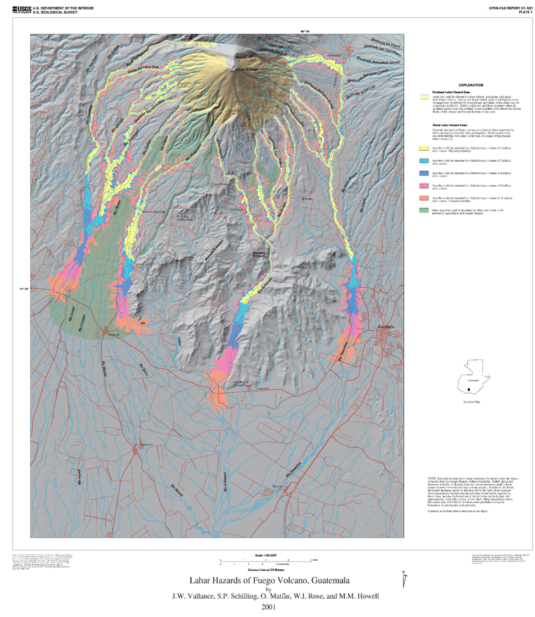
Official (foreign agency), Insert/poster-size map with accompanying report
Lahar Hazards of Fuego Volcano, Guatemala
Plate 1 (Color) in: Vallance, J.W., Schilling, S.P., Matías, O., Rose, W.I. & Howell, M.M. (2001). Volcano Hazards at Fuego and Acatenango, Guatemala. U.S. Geological Survey, Open-File Report 01-431. https://doi.org/10.3133/ofr01431
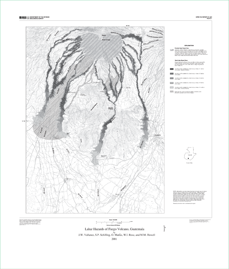
Official (foreign agency), Insert/poster-size map with accompanying report
Lahar Hazards of Fuego Volcano, Guatemala
Plate 1 (B&W) in: Vallance, J.W., Schilling, S.P., Matías, O., Rose, W.I. & Howell, M.M. (2001). Volcano Hazards at Fuego and Acatenango, Guatemala. U.S. Geological Survey, Open-File Report 01-431. https://doi.org/10.3133/ofr01431
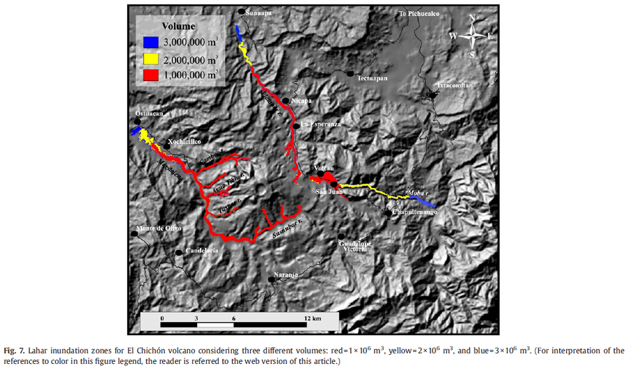
Figure in a journal article
Lahar inundation zones for El Chichón volcano considering three different volumes: red=1×10^6 m3, yellow=2×10^6 m3, and blue=3×10^6 m3.
Figure 7 in: Macías, J. L., Capra, L., Arce, J. L., Espíndola, J. M., García-Palomo, A., & Sheridan, M. F. (2008). Hazard map of El Chichón volcano, Chiapas, México: Constraints posed by eruptive history and computer simulations. Journal of Volcanology and Geothermal Research, 175(4), 444-458. https://doi.org/10.1016/j.jvolgeores.2008.02.023
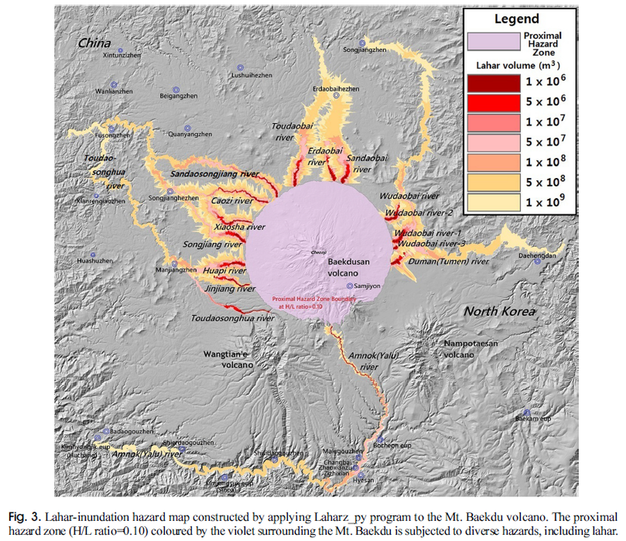
Figure in a journal article
Lahar-inundation hazard map constructed by applying Laharz_py program to the Mt. Baekdu volcano
Figure 3 in: Yun, S. H. & Chang, C. (2017). Prediction of Lahar Flow Inundation Areas Using LAHARZ_py Program: Application for the Mt. Baekdu Volcano. Economic and Environmental Geology, 50(4), 277-286. https://doi.org/10.9719/EEG.2017.50.4.277
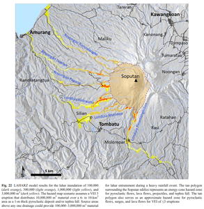
Figure in a journal article
LAHARZ model results for the lahar inundation of 100,000 (dark orange), 300,000 (light orange), 1,000,000 (light yellow), and 3,000,000 m³ (dark yellow)
Figure 22 in: Kushendratno, Pallister, J.S., Kristianto, Bina, F.R., McCausland, W., Carn, S., Haerani, N., Griswold, J., & Keeler, R. (2012). Recent explosive eruptions and volcano hazards at Soputan volcano—a basalt stratovolcano in north Sulawesi, Indonesia. Bulletin of volcanology, 74(7), 1581-1609. https://doi.org/10.1007/s00445-012-0620-2
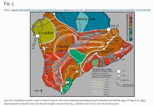
Figure in a journal article
Lava flow inundation hazard zones for Hawai‘i shown with colors indicating increasing hazard (adapted from Heliker 1990; Wright et al. 1992). Superimposed on hazard zones are channel-length contours from Fig. 4 (dashed color lines).
Figure 5 in: Rowland, S. K., Garbeil, H., & Harris, A. J. (2005). Lengths and hazards from channel-fed lava flows on Mauna Loa, Hawai ‘i, determined from thermal and downslope modeling with FLOWGO. Bulletin of Volcanology, 67(7), 634-647. https://doi.org/10.1007/s00445-004-0399-x