
Advanced Search for Maps
Showing 51-60 of 220

Official, Map in a booklet, long fact-sheet, or handbook
Hazard zones for debris flows, lahars, lava flows, and pyroclastic flows from Mount Rainier
Page 3 in: Driedger, C.L. & Scott, W.E. (2008). Mount Rainier: living safely with a volcano in your backyard. U.S. Geological Survey, Fact Sheet 2008-3062, 4 p. https://doi.org/10.3133/fs20083062
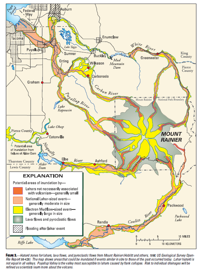
Official, Map in a booklet, long fact-sheet, or handbook
Hazard zones for lahars, lava flows, and pyroclastic flows from Mount Rainier
Figure 3 in: Driedger, C.L. & Scott, K.M. (2002). Mount Rainier: learning to live with volcanic risk. U.S. Geological Survey, Fact Sheet 034-02, 4 p. https://doi.org/10.3133/fs03402
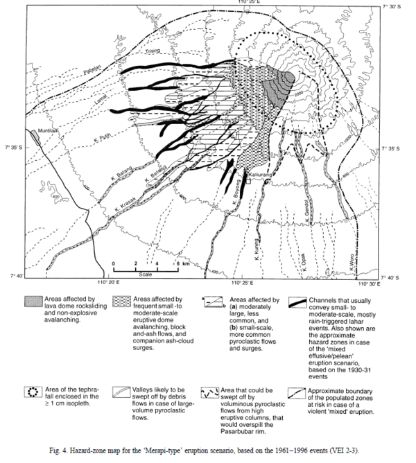
Figure in a journal article
Hazard-zone map for the 'Merapi-type' eruption scenario, based on the 1961-1996 events (VEI 2-3)
Figure 4 in: Thouret, J.-C., Lavigne, F., Kelfoun, K., & Bronto, S. (2000). Toward a revised hazard assessment at Merapi volcano, Central Java. Journal of Volcanology and Geothermal Research, 100(1-4), p. 479-502. https://doi.org/10.1016/S0377-0273(00)00152-9
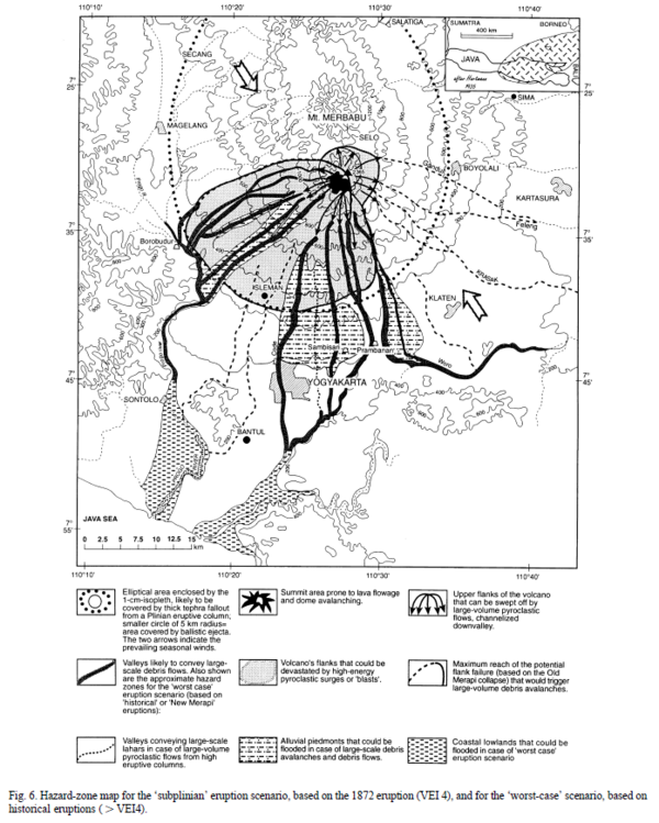
Figure in a journal article
Hazard-zone map for the 'subplinian' eruption scenario, based on the 1872 eruption (VEI 4), and for the 'worst-case' scenario, based on historical eruptions (>VEI 4)
Figure 6 in: Thouret, J.-C., Lavigne, F., Kelfoun, K., & Bronto, S. (2000). Toward a revised hazard assessment at Merapi volcano, Central Java. Journal of Volcanology and Geothermal Research, 100(1-4), p. 479-502. https://doi.org/10.1016/S0377-0273(00)00152-9
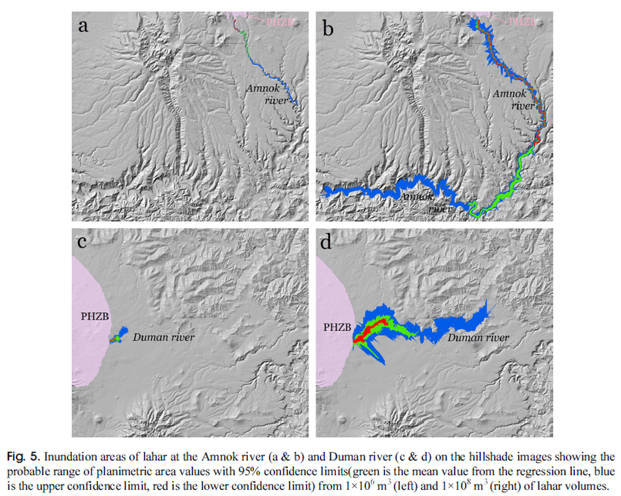
Figure in a journal article
Inundation areas of lahar at the Amnok river and Duman river
Figure 5 in: Yun, S. H. & Chang, C. (2017). Prediction of Lahar Flow Inundation Areas Using LAHARZ_py Program: Application for the Mt. Baekdu Volcano. Economic and Environmental Geology, 50(4), 277-286. https://doi.org/10.9719/EEG.2017.50.4.277
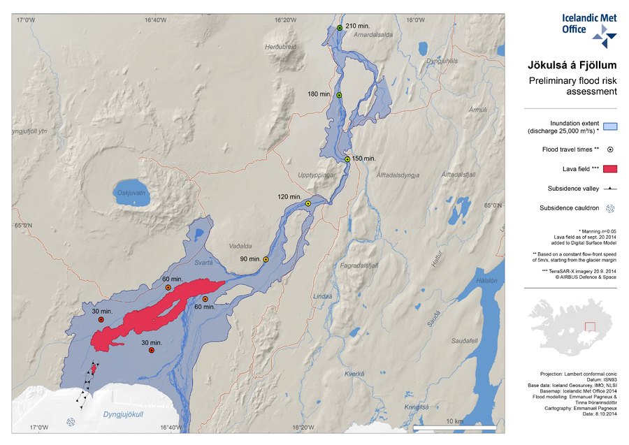
Official, Map in an information statement
Jökulsá á Fjöllum Preliminary Flood Risk Assessment
(Jökulsá á Fjöllum Preliminary Flood Risk Assessment)
Iceland Meteorological Office (IMO). (2014). Jökulsá á Fjöllum Preliminary Flood Risk Assessment.
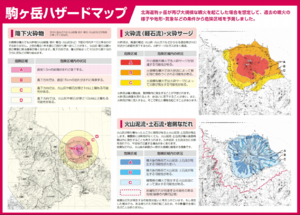
Official, Map in a booklet, long fact-sheet, or handbook
Komagatake Hazard Map
Nanae Town. Nanae Town Disaster Prevention Guide Map.
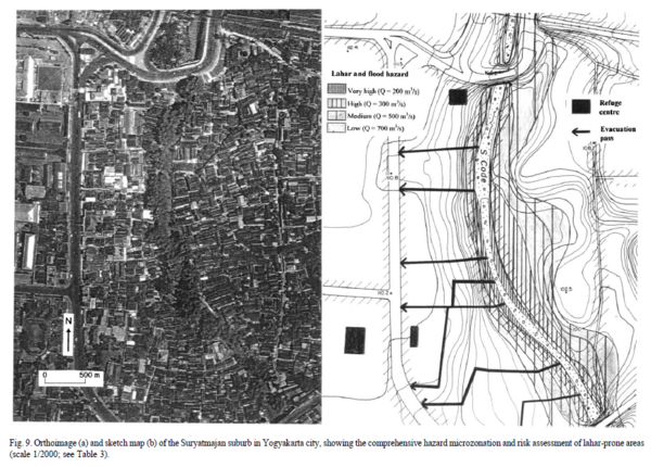
Figure in a journal article
Lahar and flood hazard
Figure 9 in: Thouret, J.-C., Lavigne, F., Kelfoun, K., & Bronto, S. (2000). Toward a revised hazard assessment at Merapi volcano, Central Java. Journal of Volcanology and Geothermal Research, 100(1-4), p. 479-502. https://doi.org/10.1016/S0377-0273(00)00152-9
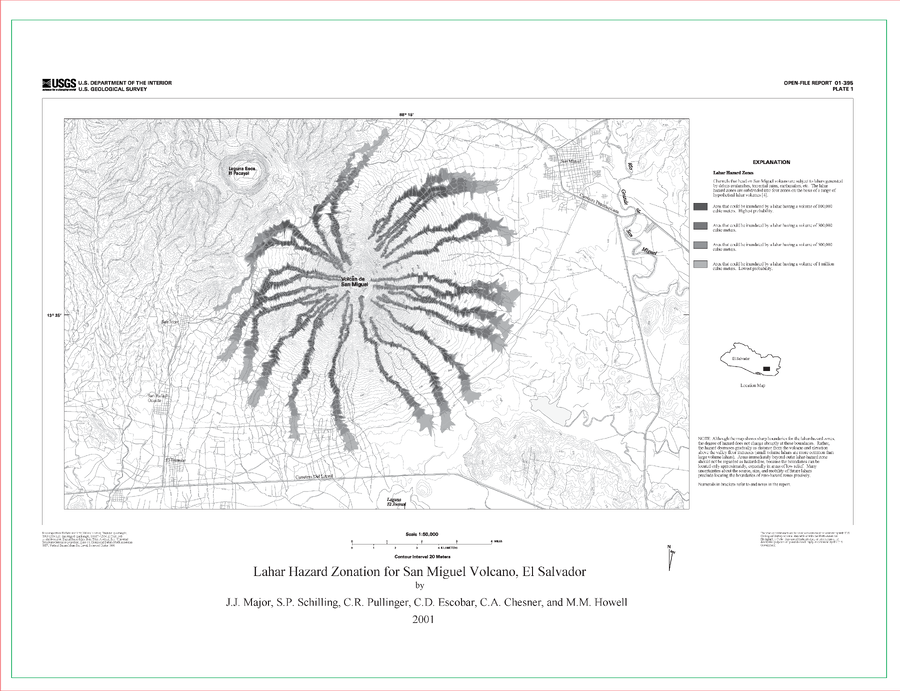
Official (foreign agency), Insert/poster-size map with accompanying report
Lahar Hazard Zonation for San Miguel Volcano, El Salvador
Plate 1 in: Major, J.J., Schilling, S.P., Pullinger, C.R., Escobar, C.D., Chesner, C.A., & Howell, M.M. (2001). Lahar-Hazard Zonation for San Miguel Volcano, El Salvador. U.S. Geological Survey, Open-File Report 2001-395, 16 p., 1 plate. https://doi.org/10.3133/ofr01395
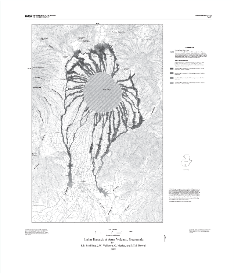
Official (foreign agency), Insert/poster-size map with accompanying report
Lahar Hazards at Agua Volcano, Guatemala
Plate 1 in: Schilling, S.P., Vallance, J.W., Matías, O., & Howell, M.M. (2001). Lahar Hazards at Agua Volcano, Guatemala. U.S. Geological Survey, Open-File Report 01-432, 16 p., 1 plate. https://doi.org/10.3133/ofr01432