
Advanced Search for Maps
Showing 61-70 of 218
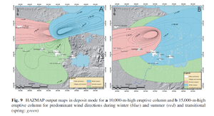
Figure in a journal article
HAZMAP output maps in deposit mode for a 10,000-m-high eruptive column and b 15,000-m-high eruptive column for predominant wind directions during winter (blue) and summer (red) and transitional (spring: green)
Figure 9 in: Sieron, K., Capra, L., & Rodríguez-Elizararrás, S. (2014). Hazard assessment at San Martín volcano based on geological record, numerical modeling, and spatial analysis. Natural hazards, 70(1), 275-297. https://doi.org/10.1007/s11069-013-0807-7
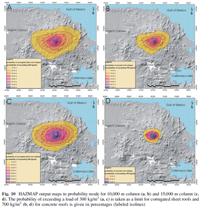
Figure in a journal article
HAZMAP output maps in probability mode for 10,000 m column (a, b) and 15,000 m column (c, d).
Figure 10 in: Sieron, K., Capra, L., & Rodríguez-Elizararrás, S. (2014). Hazard assessment at San Martín volcano based on geological record, numerical modeling, and spatial analysis. Natural hazards, 70(1), 275-297. https://doi.org/10.1007/s11069-013-0807-7
Official, Figure in a journal article
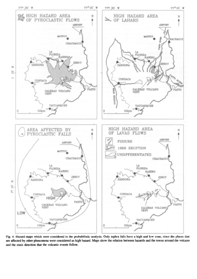
High Hazard Area of Pyroclastic Flows. High Hazard Area of Lahars. Area Affedted by Pyroclastic Falls. High Hazard Area of Lavas Flows.
Figure 4 in: Artunduaga, A.D.H., & Jiménez, G.P.C. (1997). Third version of the hazard map of Galeras Volcano, Colombia. Journal of Volcanology and Geothermal research, 77(1-4), p. 89-100. https://doi.org/10.1016/S0377-0273(96)00088-1
Official (foreign agency), Insert/poster-size map with accompanying report
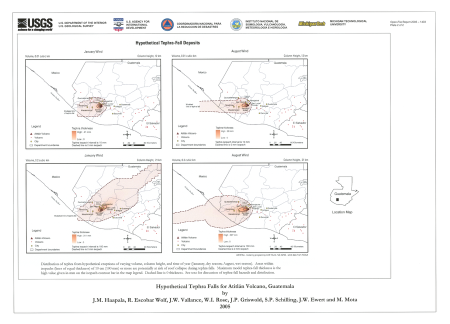
Hypothetical Tephra-fall Deposits
Plate 2 in: Haapala, J. M., Escobar Wolf, R., Vallance, J. W., Rose, W. I., Griswold, J. P., Schilling, S. P., Ewert, J.W., & Mota, M. (2005). Volcanic hazards at Atitlan volcano, Guatemala. U.S. Geological Survey, Open-File Report, 1403. https://doi.org/10.3133/ofr20051403
Official, Figure in a journal article
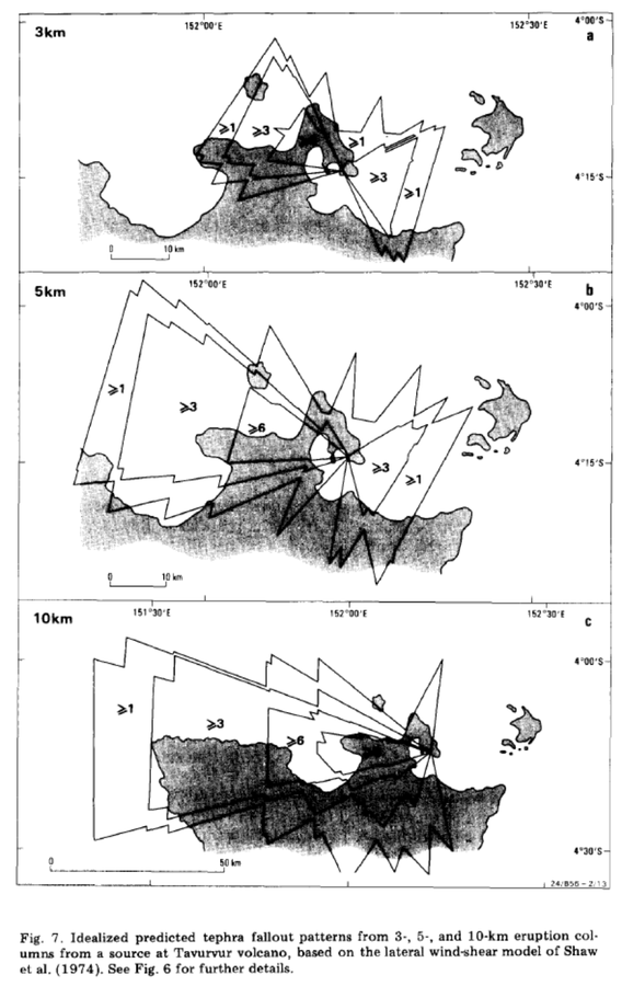
Idealized predicted tephra fallout patterns from 3-, 5-, and 10-km eruption columns from a source at Tavurvur volcano
Figure 7 in: McKee, C. O., Johnson, R. W., Lowenstein, P. L., Riley, S. J., Blong, R. J., De Saint Ours, P., & Talai, B. (1985). Rabaul caldera, Papua New Guinea: volcanic hazards, surveillance, and eruption contingency planning. Journal of Volcanology and Geothermal Research, 23(3-4), p. 195-237. https://doi.org/10.1016/0377-0273(85)90035-6
Official, Figure in a journal article
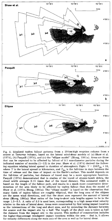
Idealized tephra fallout patterns from a 20-km-high eruption column from a source at Tavurvur volcano
Figure 6 in: McKee, C. O., Johnson, R. W., Lowenstein, P. L., Riley, S. J., Blong, R. J., De Saint Ours, P., & Talai, B. (1985). Rabaul caldera, Papua New Guinea: volcanic hazards, surveillance, and eruption contingency planning. Journal of Volcanology and Geothermal Research, 23(3-4), p. 195-237. https://doi.org/10.1016/0377-0273(85)90035-6
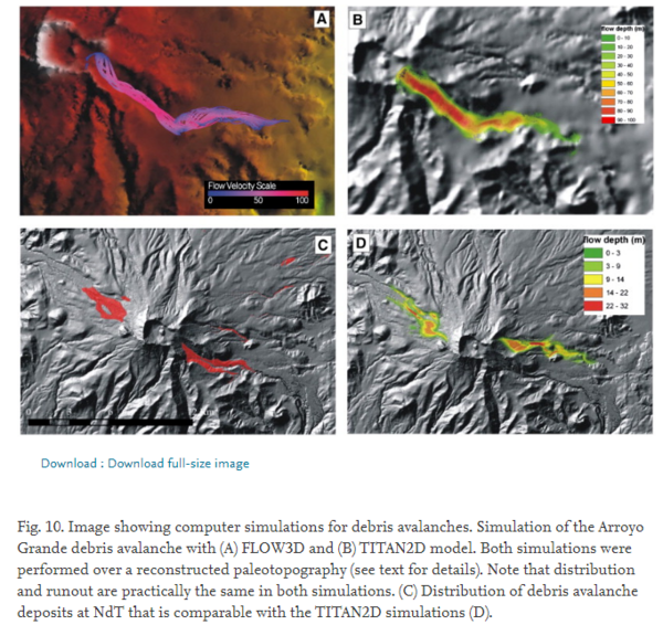
Figure in a journal article
Image showing computer simulations for debris avalanches
Figure 10 in: Capra, L., Norini, G., Groppelli, G., Macías, J.L., & Arce, J.L. (2008). Volcanic hazard zonation of the Nevado de Toluca volcano, México. Journal of Volcanology and Geothermal Research, 176(4), p. 469-484. https://doi.org/10.1016/j.jvolgeores.2008.04.016
Figure in a journal article
Impact crater distributions from possible future eruption scenarios modelled using the Tsunematsu et al. (2013) ballistic trajectory model
Figure 11 in: Fitzgerald, R. H., Tsunematsu, K., Kennedy, B. M., Breard, E. C. P., Lube, G., Wilson, T. M., Jolly, A.D., Pawson, J., Rosenburg, M.D., & Cronin, S. J. (2014). The application of a calibrated 3D ballistic trajectory model to ballistic hazard assessments at Upper Te Maari, Tongariro. Journal of volcanology and geothermal research, 286, p. 248-262. https://doi.org/10.1016/j.jvolgeores.2014.04.006
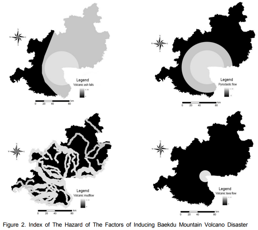
Figure in a journal article
Index of The Hazard of The Factors of Inducing Baekdu Mountain Volcano Disaster
Figure 2 in: Xiao-Jiao, N., Choi, Y. S., & Ying, N. (2014). A Study on Integrated Assessment of Baekdu Mountain Volcanic Aisaster risk Based on GIS. Journal of Korea Spatial Information Society. Korea Spatial Information Society. https://doi.org/10.12672/ksis.2014.22.4.077
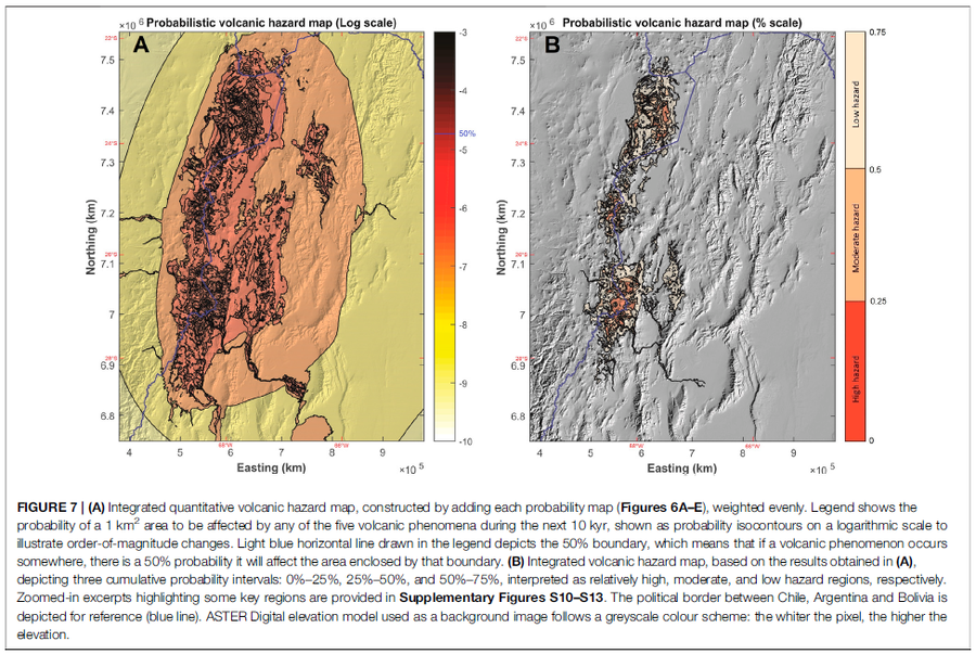
Figure in a journal article
Integrated quantitative volcanic hazard map, constructed by adding each probability map (Figures 6A–E), weighted evenly
Figure 7 in: Bertin, D., Lindsay, J.M., Cronin, S.J., de Silva, S.L., Connor, C.B., Caffe, P.J., Grosse, P., Báez, W., Bustos, E., & Constantinescu, R. (2022). Probabilistic Volcanic Hazard Assessment of the 22.5–28° S Segment of the Central Volcanic Zone of the Andes. Frontiers in Earth Science, 10. https://doi.org/10.3389/feart.2022.875439