
Advanced Search for Maps
Showing 21-30 of 98
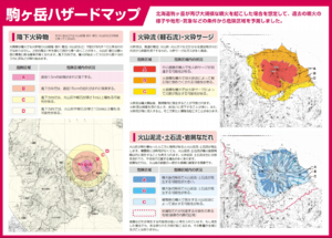
Official, Map in a booklet, long fact-sheet, or handbook
Komagatake Hazard Map
Nanae Town. Nanae Town Disaster Prevention Guide Map.
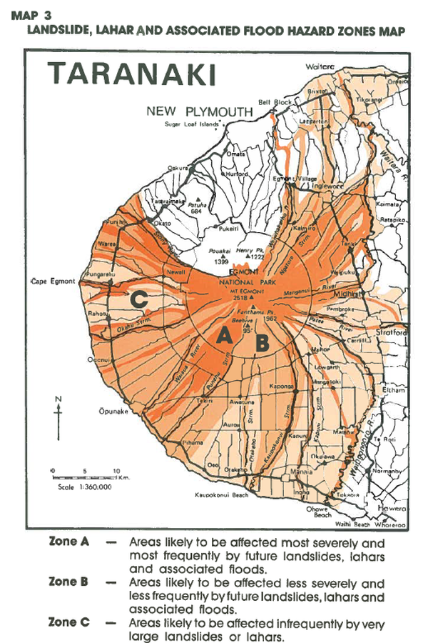
Official, Figure in hazard assessment
Landslide, Lahar and Associated Flood Hazard Zones Map
Map 3, Page 20 in: Neall, V.E. & Alloway, B.V. (1993). Volcanic hazards at Egmont volcano. Volcanic Hazards Working Group of the Scientific Advisory Committee, Ministry of Civil Defence. Volcanic Hazards Information Series, Number One, 2nd ed. 31 p.
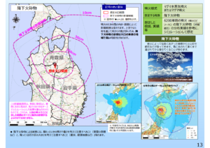
Official, Map in a booklet, long fact-sheet, or handbook
Large-scale eruption (assuming billions of cubic meters of magma eruption) pyroclastic fall
Page 13 in: Towada Volcanic Hazards Mitigation Committee. (2018). Towada Volcano Hazard Expected Impact Area Map. Omori Prefecture Disaster Risk Management Division, Akita Prefecture Disaster Prevention Division, Nagano City General Affairs Division, Kosaka Town General Affairs Division.
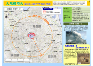
Official, Map in a booklet, long fact-sheet, or handbook
Large-scale eruption (assuming billions of cubic meters of magma eruption) pyroclastic flow/pyroclastic surge
Page 12 in: Towada Volcanic Hazards Mitigation Committee. (2018). Towada Volcano Hazard Expected Impact Area Map. Omori Prefecture Disaster Risk Management Division, Akita Prefecture Disaster Prevention Division, Nagano City General Affairs Division, Kosaka Town General Affairs Division.
Official, Figure in hazard assessment
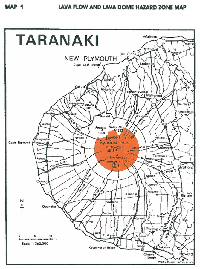
Lava Flow and Lava Dome Hazard Zone Map
Map 1, Page 15 in: Neall, V.E. & Alloway, B.V. (1993). Volcanic hazards at Egmont volcano. Volcanic Hazards Working Group of the Scientific Advisory Committee, Ministry of Civil Defence. Volcanic Hazards Information Series, Number One, 2nd ed. 31 p.
Official, Map in a booklet, long fact-sheet, or handbook
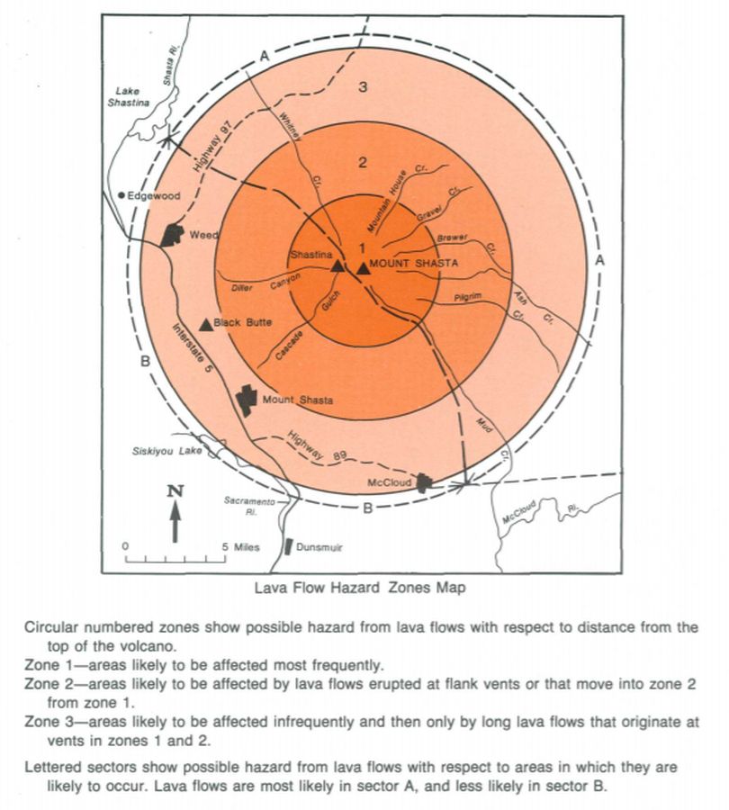
Lava Flow Hazard Zones Map
Page 17 in: Crandell, D.R. & Nichols, D.R. (1989). Volcanic hazards at Mount Shasta, California. U.S. Geological Survey, General Information Product, 22 p. https://doi.org/10.3133/70039409
Official, Map in a booklet, long fact-sheet, or handbook
Magma eruption hazard map
Page 7 in: Nasudake Volcano Disaster Prevention Council. (2014). Nasudake Volcano Disaster Prevention Handbook.
Official, Map in a booklet, long fact-sheet, or handbook
Magma eruption hazard map
Page 7 in: Nasudake Volcano Disaster Prevention Council. (2010). Volcanic disaster prevention handbook of Mt. Nasudake.

Official, Figure on website
Map showing caldera features and caldera-related hazards at Medicine Lake volcano
U.S. Geological Survey (USGS). (2008). Map showing caldera features and caldera-related hazards at Medicine Lake volcano. U.S. Geological Survey. Medicine Lake Hazards. https://www.usgs.gov/volcanoes/medicine-lake/hazards (Modified from: Scientitic Investigations Report 2007-5174-A)
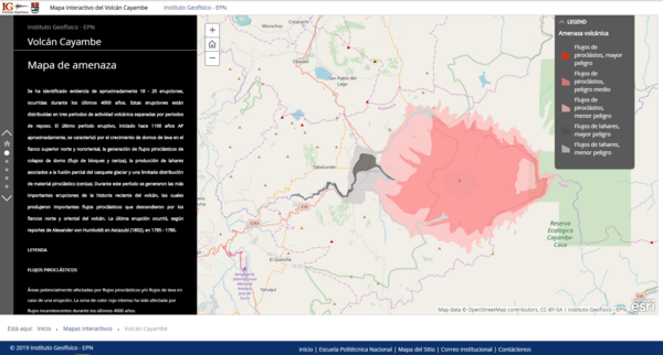
Official, Interactive web-based map
Mapa Interactivo del Volcán Cayambe
(Cayambe Volcano Interactive Map)
Instituto Geofísico de la Escuela Politecnica Nacional (IG-EPN). (2019). Mapa Interactivo del Volcán Cayambe.