
Advanced Search for Maps
Showing 41-50 of 123
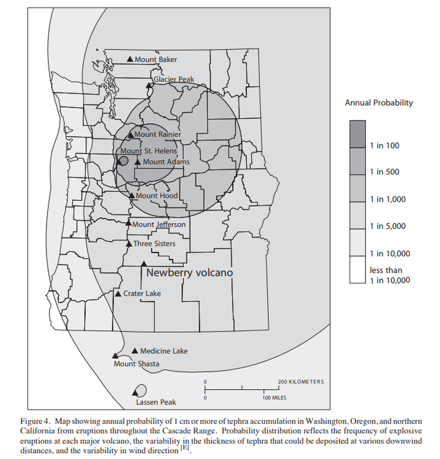
Official, Figure in hazard assessment
Map showing annual probability of 1 cm or more of tephra accumulation in Washington, Oregon, and northern California from eruptions throughout the Cascade Range.
Figure 4 in: Sherrod, D.R., Mastin, L.G., Scott, W.E. & Schilling, S.P. (1997). Volcano hazards at Newberry Volcano, Oregon. U.S. Geological Survey, Open-File Report 97-513, 14 p. https://doi.org/10.3133/ofr97513
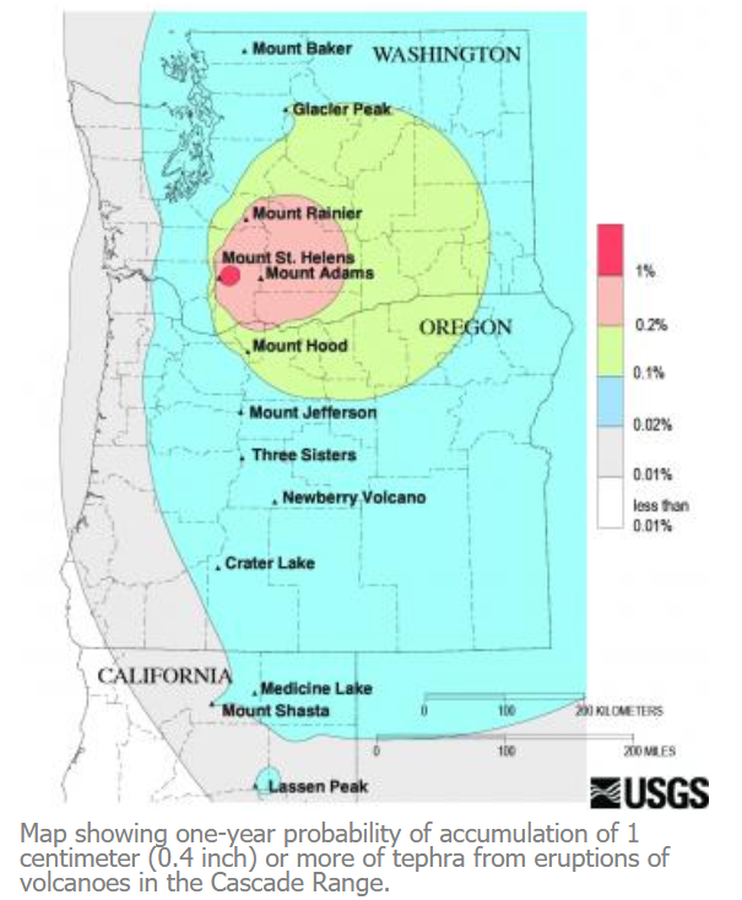
Official, Figure on website
Map showing one-year probability of accumulation of 1 centimeter (0.4 inch) or more of tephra from eruptions of volcanoes in the Cascade Range.
Nathensen, M. (2013). Map showing one-year probability of accumulation of 1 centimeter (0.4 inch) or more of tephra from eruptions of volcanoes in the Cascade Range. U.S. Geological Survey. Mount Bachelor Hazards. https://www.usgs.gov/volcanoes/mount-bachelor/hazards
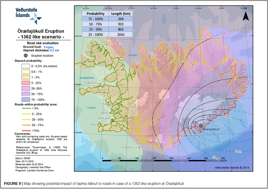
Figure in a journal article
Map showing potential impact of tephra fallout to roads in case of a 1362-like eruption at Öræfajökull
Figure 9 in: Barsotti, S., Di Rienzo, D. I., Thordarson, T., Björnsson, B. B., & Karlsdóttir, S. (2018). Assessing impact to infrastructures due to tephra fallout from Öræfajökull volcano (Iceland) by using a scenario-based approach and a numerical model. Frontiers in Earth Science, 6, 196. https://doi.org/10.3389/feart.2018.00196
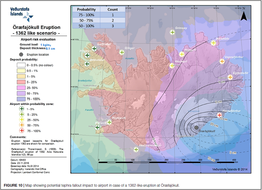
Figure in a journal article
Map showing potential tephra fallout impact to airport in case of a 1362-like eruption at Öræfajökull
Figure 10 in: Barsotti, S., Di Rienzo, D. I., Thordarson, T., Björnsson, B. B., & Karlsdóttir, S. (2018). Assessing impact to infrastructures due to tephra fallout from Öræfajökull volcano (Iceland) by using a scenario-based approach and a numerical model. Frontiers in Earth Science, 6, 196. https://doi.org/10.3389/feart.2018.00196
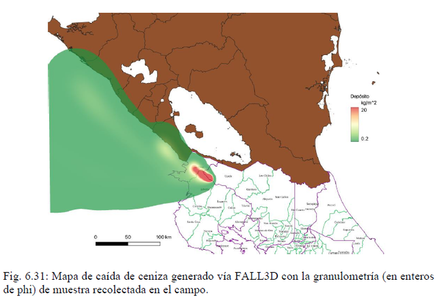
Official, Figure in hazard assessment
Mapa de caída de ceniza generado vía FALL3D con la granulometría (en enteros de phi) de muestra recolectada en el campo
(Ash fall map generated via FALL3D with the granulometry (in phi integers) of sample collected in the field)
Figure 6.31 in: Alvarado, G.E., Brenes-André, J., Venegas, L., Alpízar, Y., Núñez, S., Sánchez, M., Abarca, K., Abarca, J., Báez, W.A., Sibaja, J.P., Esquivel, L., & Arcia, T. (2022). Análisis del Peligro Volcánico del Rincón de la Vieja, Costa Rica. Instituto Costarricense de Electricidad (ICE). Setiembre 2022.

Official, Map sheet or poster
Mapa de los "Volcanes Activos" del Ecuador
(Map of the "Active Volcanoes" of Ecuador)
Salazar, E. & Bermúdez, R. (1982). Mapa de los "Volcanes Activos" del Ecuador. Mapa Base del Ecuador, Vulcanología. Ministerio de Energía y Minas, Instituto Ecuatoriano de Minería, Quito.
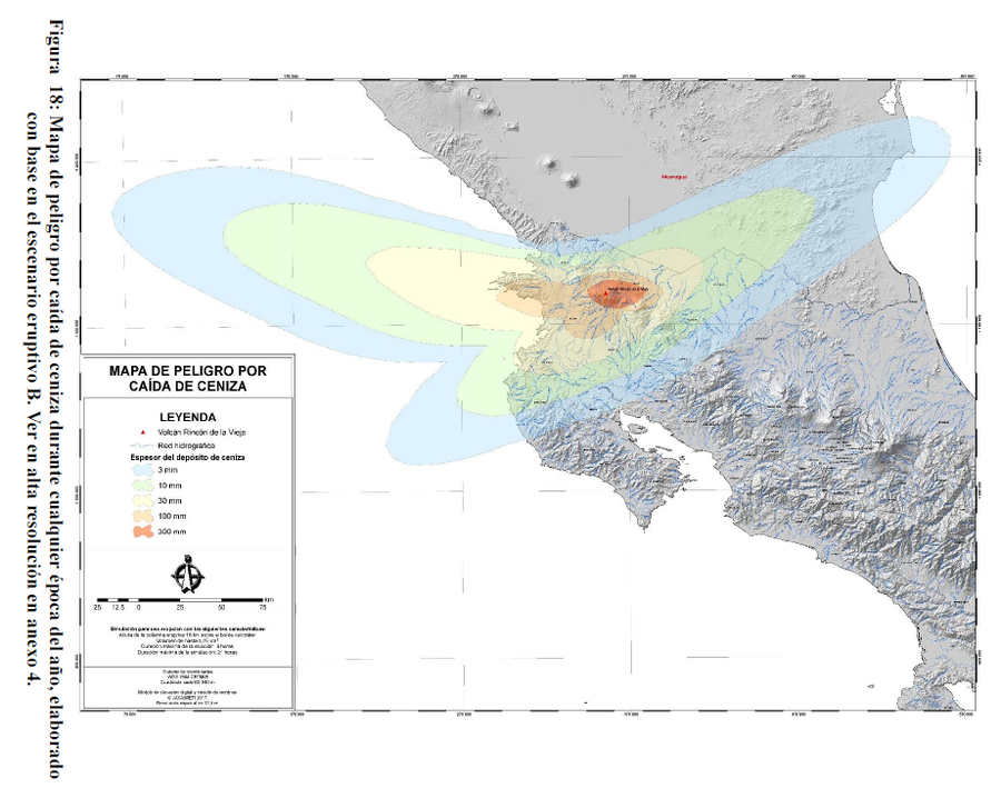
Figure in a thesis or dissertation
Mapa de Peligro por Caída de Ceniza
(Ash Fall Hazard Map)
Figure 18 in: Alpízar, Y. (2018). Mapa Preliminar de Peligros Volcánicos para el Volcán Rincón de la Vieja (Costa Rica): Descripción de un Escenario de Afectación por Lahares. Ciudad Universitaria Rodrigo Facio, Costa Rica. 160 p.
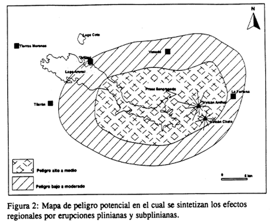
Official, Figure in hazard assessment
Mapa de peligro potencial en el cual se sintetizan los efectos regionales por erupciones plinianas y subplinianas
(Map of potential danger in which the regional effects of plinian and subplinian eruptions are synthesized)
Figure 2 in: Alvarado, G.E., Soto, G.J., Ghigliotti, M., & Frullani, A. (1997). Peligro volcánico del Arenal. Boletín OSIVAM, 8(15-16), p. 62-82.
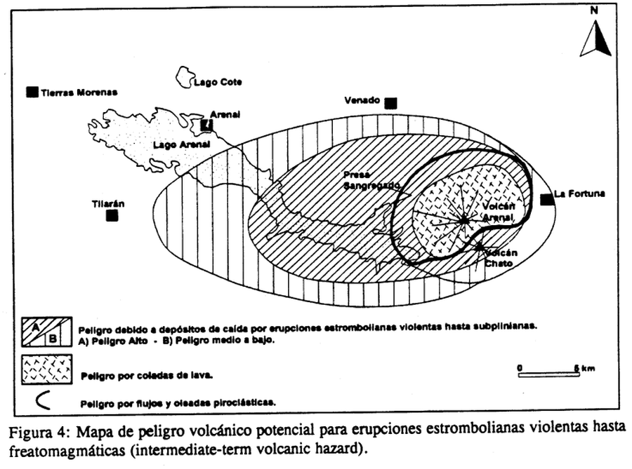
Official, Figure in hazard assessment
Mapa de peligro volcánico potencial para erupciones estrombolianas violentas hasta freatomagmáticas (intermediate-term volcanic hazard)
(Potential volcanic hazard map for violent strombolian to phreatomagmatic (intermediate-term volcanic hazard) eruptions)
Figure 4 in: Alvarado, G.E., Soto, G.J., Ghigliotti, M., & Frullani, A. (1997). Peligro volcánico del Arenal. Boletín OSIVAM, 8(15-16), p. 62-82.
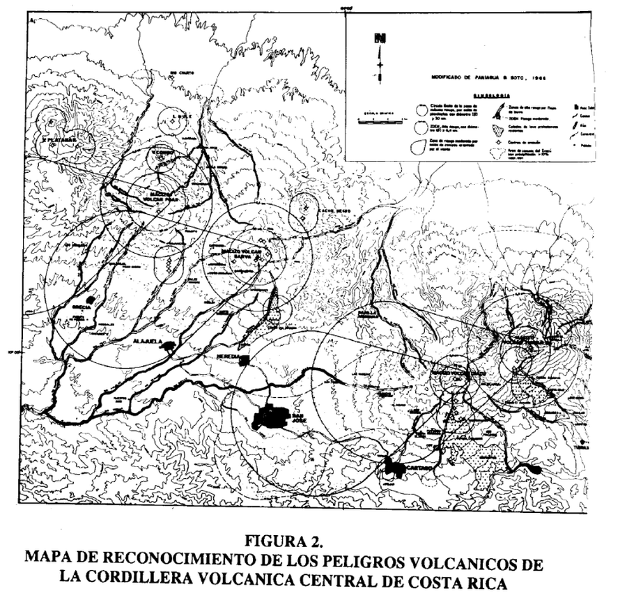
Figure in a journal article
Mapa de Reconocimiento de los Peligros Volcánicos de la Cordillera Volcánica Central de Costa Rica
(Reconnaissance Map of the Volcanic Hazards of the Central Volcanic Cordillera of Costa Rica)
Figure 2 in: Soto, G.J. & Paniagua, S. (1992). La Cordillera Volcánica Central (Costa Rica): sus peligros potenciales y prevenciones. Revista Geográfica de América Central, (25-26), 291-304.